 |
SEALEVEL STATION CATALOG (SSC) |
|
|
|
|
|
| Station catalog metadata [edit] | [station overview] |
|---|
| SSC ID | SSC-toco | | Station Name | Tocopilla_CL | | Country | Chile | | Latitude | -22.093757 | | Longitude | -70.211653 | | DateLastModified | 2015-10-22 19:02:29 |
| Linked codes |
|---|
| Codes | Location | Latitude | Longitude | Sensors | IOC: toco | Tocopilla_CL | -22.093748 | -70.211537 | prs, rad, bat |
IOC: toco2 | Tocopilla_CL | -22.093748 | -70.211537 | prs, rad |
IOC: toco3 | Tocopilla_CL | -22.093748 | -70.211537 | prs, rad |
PTWC: toc2 | Tocopilla_CL | -22.0938 | -70.2115 | prs, rad |
PTWC: toco | Tocopilla_CL | -23.6542 | -70.4046 | prs, rad |
PSMSL: 2466 | TOCOPILLA | -22.093888888888888 | -70.21166666666667 | N/A |
| Distributed metadata source: IOC Sea Level Station Monitoring Facility toco |
|---|
| GTS station code | ADC191A6 |
| GTS message type | SXCH40 |
| Status | Operational |
| Local Contact | Servicio Hidrográfico y Oceanográfico de la Armada ( Chile ) |
| Connection | GTS message |
| Country | Chile |
| Sensor 1 | |
| Type of sensor | prs |
| Sampling rate (min) | 1 |
| Sensor 2 | |
| Type of sensor | rad |
| Sampling rate (min) | 1 |
| Sensor 3 | |
| Type of sensor | bat |
| Sampling rate (min) | 5 |
| Distributed metadata source: IOC Sea Level Station Monitoring Facility toco2 |
|---|
| Status | Operational |
| Local Contact | Servicio Hidrográfico y Oceanográfico de la Armada ( Chile ) |
| Connection | WEB service |
| Country | Chile |
| Sensor 1 | |
| Type of sensor | prs |
| Sampling rate (min) | 1 |
| Sensor 2 | |
| Type of sensor | rad |
| Sampling rate (min) | 1 |
| Distributed metadata source: IOC Sea Level Station Monitoring Facility toco3 |
|---|
| Status | Down |
| Local Contact | Servicio Hidrográfico y Oceanográfico de la Armada ( Chile ) |
| Connection | WEB service |
| Country | Chile |
| Sensor 1 | |
| Type of sensor | prs |
| Sampling rate (min) | 1 |
| Sensor 2 | |
| Type of sensor | rad |
| Sampling rate (min) | 1 |
| Distributed metadata source: PTWC COMP META file |
| DCP ID | 1234AAC3 |
| WMO | FTPI00 |
| Samp Rate | 1 |
| Num# Samp | 10 |
| Unit | m |
| Scale | 1.0000 |
| Xmt Int. | 005 |
| Fst Min. | 0000 |
| HAR | 1 |
| Owner | SHOA |
| Distributed metadata source: PSMSL |
| Name | TOCOPILLA |
| Is RLR | N |
| Has RLR Diagram | N link |
| QC Flag | N |
| Last Updated | 2025-06-12 |
| Supplier | HYDROGRAPHIC AND OCEANOGRAPHIC SERVICE OF THE CHILEAN NAVY |
| Address | Hydrographic and Oceanographic Service of the Chilean Navy, Errazuriz 254, Playa Ancha , Valparaiso, CHILE |
| Metric Start | 2011 |
| Metric End | 2024 |
| Metric Completeness | 94.0 |
| Download metric sea level data. | Use only with extreme caution. |
IOC Sea Level Station Monitoring Facility - realtime graph for 'toco' 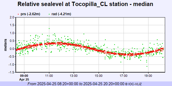 IOC Sea Level Station Monitoring Facility - realtime graph for 'toco2' 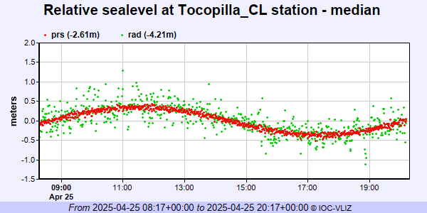 IOC Sea Level Station Monitoring Facility - realtime graph for 'toco3'  PSMSL Annual Mean Sea Level for '2466'  PSMSL Monthly Mean Sea Level for '2466' 
|
|
|