 |
SEALEVEL STATION CATALOG (SSC) |
|
|
|
|
|
| Station catalog metadata [edit] | [station overview] |
|---|
| SSC ID | SSC-stqy | | Station Name | Saint-Quay-Portrieux | | Country | France | | Latitude | 48.648195 | | Longitude | -2.822498 | | DateLastModified | 2022-01-22 11:20:11 |
| Linked codes |
|---|
| Codes | Location | Latitude | Longitude | Sensors | IOC: stqy | Saint-Quay-Portrieux | 48.648195 | -2.822498 | rad |
IOC: stqy2 | Saint-Quay-Portrieux 2 | 48.648195 | -2.822498 | rad |
PTWC: stqy | Saint_Quay_Port_FR | 48.6482 | -2.8225 | rad |
PSMSL: 2365 | SAINT QUAY PORTRIEUX | 48.6475 | -2.8180549999999998 | N/A |
| Distributed metadata source: IOC Sea Level Station Monitoring Facility stqy |
|---|
| Status | Operational |
| Local Contact | Service hydrographique et océanographique de la marine ( France ) |
| Other Contact | Service hydrographique et océanographique de la marine ( France ) |
| Connection | FTP box |
| Country | France |
| Sensor 1 | |
| Type of sensor | rad |
| Sampling rate (min) | 1 |
| Distributed metadata source: IOC Sea Level Station Monitoring Facility stqy2 |
|---|
| GTS station code | FR0506 |
| GTS message type | SZFR01 |
| Status | Operational |
| Local Contact | Service hydrographique et océanographique de la marine ( France ) |
| Other Contact | Service hydrographique et océanographique de la marine ( France ) |
| Connection | GTS message |
| Country | France |
| Sensor 1 | |
| Type of sensor | rad |
| Sampling rate (min) | 1 |
| Distributed metadata source: PTWC COMP META file |
| DCP ID | 187AF03C |
| WMO | SZFR01 |
| Samp Rate | 1 |
| Num# Samp | 12 |
| Unit | M |
| Scale | 1.0000 |
| Xmt Int. | 006 |
| Fst Min. | 0004 |
| HAR | 0 |
| Owner | SHOM |
| Distributed metadata source: PSMSL |
| Name | SAINT QUAY PORTRIEUX |
| Is RLR | Y |
| Has RLR Diagram | Y link |
| QC Flag | N |
| Last Updated | 2026-02-20 |
| Supplier | SERVICE HYD. ET OCEAN. DE LA MARINE |
| Address | SHOM, 13 rue de Chatelier, 29200 BREST , FRANCE |
| Metric Start | 2018 |
| Metric End | 2025 |
| Metric Completeness | 77.1 |
| RLR Start | 2018 |
| RLR End | 2025 |
| RLR Completeness | 77.1 |
| Download metric sea level data. | Use only with extreme caution. |
IOC Sea Level Station Monitoring Facility - realtime graph for 'stqy' 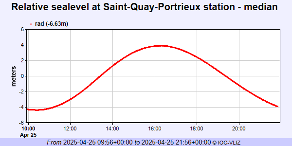 IOC Sea Level Station Monitoring Facility - realtime graph for 'stqy2' 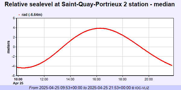 PSMSL Annual Mean Sea Level for '2365' 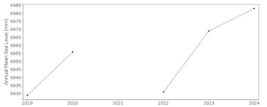 PSMSL Monthly Mean Sea Level for '2365' 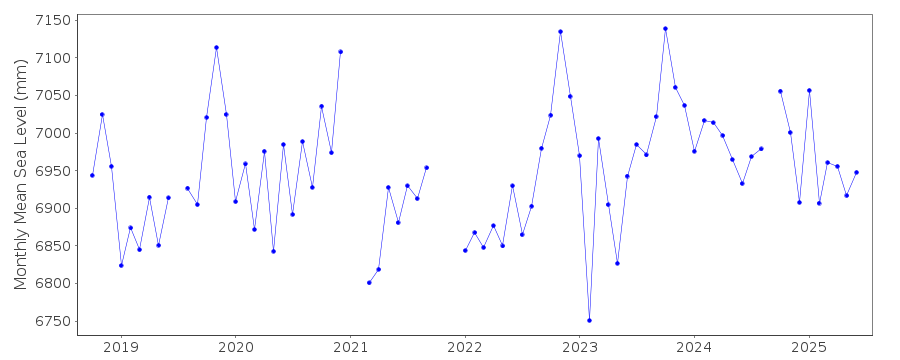
|
|
|