| Station catalog metadata [edit] | [station overview] |
|---|
| SSC ID | SSC-ptca |
| Station Name | Punta Cana |
| Country | Dominican Republic |
| Latitude | 18.504603 |
| Longitude | -68.375519 |
| DateLastModified | 2015-10-22 19:02:29 |
| Linked codes |
|---|
| Codes | Location | Latitude | Longitude | Sensors |
IOC: ptca | Punta Cana | 18.504603 | -68.375519 | prs, rad, ra2, bat, sw1, sw2, ra3 |
UHSLC: 776 | Punta Cana | 18.5 | -68.38 | N/A |
PTWC: pcan | Punta_Cana_DO | 18.5046 | -68.3755 | prs, ra2, rad |
PSMSL: 2342 | PUNTA CANA B | 18.505 | -68.375 | N/A |
SONEL_GPS: 3558 | PUNTA CANA | 18.56394444 | -68.35938889 | N/A |
SONEL_TG: 3557 | PUNTA CANA | 18.50500000 | -68.37500000 | N/A |
| Distributed metadata source: IOC Sea Level Station Monitoring Facility ptca |
|---|
| GTS station code | 301434061821990 |
| GTS message type | SZXX01 |
| Status | Operational |
| Local Contact | Oficina Nacional de Meteorología (Dominican Republic) |
| Other Contact | University of Hawaii Sea Level Center ( USA ) |
| Other Contact | Puerto Rico Seismic Network ( USA ) |
| Other Contact | International Tsunami Information Center Caribbean Office ( USA ) |
| Connection | GTS message |
| Country | Dominican Republic |
| Sensor 1 | |
| Type of sensor | prs |
| Sampling rate (min) | 1 |
| Sensor 2 | |
| Type of sensor | rad |
| Sampling rate (min) | 1 |
| Sensor 3 | |
| Type of sensor | ra2 |
| Sampling rate (min) | 1 |
| Sensor 4 | |
| Type of sensor | bat |
| Sampling rate (min) | 5 |
| Sensor 5 | |
| Type of sensor | sw1 |
| Sampling rate (min) | 1 |
| Sensor 6 | |
| Type of sensor | sw2 |
| Sampling rate (min) | 1 |
| Sensor 7 | |
| Type of sensor | ra3 |
| Sampling rate (min) | 1 |
| Distributed metadata source: PTWC COMP META file |
| DCP ID | 301434061821990 |
| WMO | SZXX01 |
| Samp Rate | 1 |
| Num# Samp | 5 |
| Unit | M |
| Scale | 1.0000 |
| Xmt Int. | 005 |
| Fst Min. | 0001 |
| HAR | 1 |
| Owner | UHSLC |
| Distributed metadata source: UHSLC |
| UHSLC id | 776 |
| SSC id | ptca |
| UHSLC geojson | https://uhslc.soest.hawaii.edu/data/meta.geojson |
| Research quality data version a | 2010-06-19 - 2018-12-31 |
| RQ basin | atlantic |
| Fast delivery | 2010-06-19 - 2026-01-31 |
| Distributed metadata source: PSMSL |
| Name | PUNTA CANA B |
| UHSLC ID | 776 |
| Is RLR | Y |
| Has RLR Diagram | Y link |
| QC Flag | N |
| Old ID | 936/005 |
| Last Updated | 2023-03-07 |
| Supplier | UNIVERSITY OF HAWAII SEA LEVEL CENTER |
| Address | University of Hawaii Sea Level Center, Department of Oceanography Division of Natural Sciences, 1000 Pope Road, Honolulu, Hawaii 96822, UNITED STATES |
| Metric Start | 2010 |
| Metric End | 2018 |
| Metric Completeness | 94.4 |
| RLR Start | 2010 |
| RLR End | 2018 |
| RLR Completeness | 94.4 |
| Download metric sea level data. | Use only with extreme caution. |
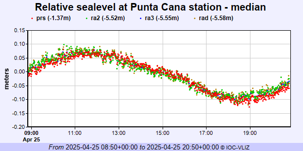
IOC Sea Level Station Monitoring Facility - realtime graph for 'ptca'
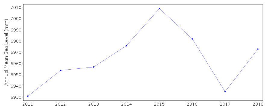
PSMSL Annual Mean Sea Level for '2342'
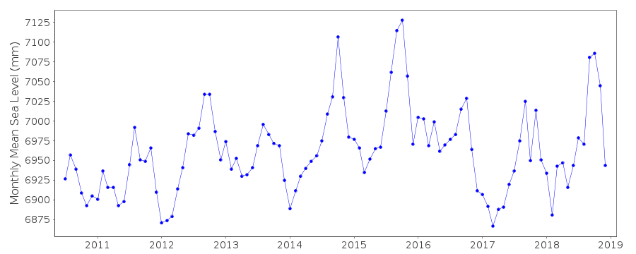
PSMSL Monthly Mean Sea Level for '2342'