 |
SEALEVEL STATION CATALOG (SSC) |
|
|
|
|
|
| Station catalog metadata [edit] | [station overview] |
|---|
| SSC ID | SSC-lymg | | Station Name | Lymington | | Country | United Kingdom | | Latitude | 50.74031 | | Longitude | -1.50708 | | DateLastModified | 2015-10-22 19:02:29 |
| Linked codes |
|---|
| Codes | Location | Latitude | Longitude | Sensors | IOC: lymg | Lymington | 50.74031 | -1.50708 | stp |
PSMSL: 2281 | LYMINGTON | 50.740296 | -1.507122 | N/A |
| Distributed metadata source: IOC Sea Level Station Monitoring Facility lymg |
|---|
| Status | Operational |
| Local Contact | Channel Coastal Observatory ( UK ) |
| Connection | WEB service |
| Country | UK |
| Sensor 1 | |
| Type of sensor | stp |
| Sampling rate (min) | 0.1666 |
| Distributed metadata source: PSMSL |
| Name | LYMINGTON |
| Is RLR | Y |
| Has RLR Diagram | Y link |
| QC Flag | N |
| Old ID | 170/136 |
| Last Updated | 2024-07-11 |
| Supplier | CHANNEL COASTAL OBSERVATORY |
| Address | National Oceanography Centre, Waterfront Campus, European Way, Southampton, UNITED KINGDOM |
| Metric Start | 2008 |
| Metric End | 2023 |
| Metric Completeness | 77.1 |
| RLR Start | 2008 |
| RLR End | 2023 |
| RLR Completeness | 77.1 |
| Download metric sea level data. | Use only with extreme caution. |
IOC Sea Level Station Monitoring Facility - realtime graph for 'lymg'  PSMSL Annual Mean Sea Level for '2281' 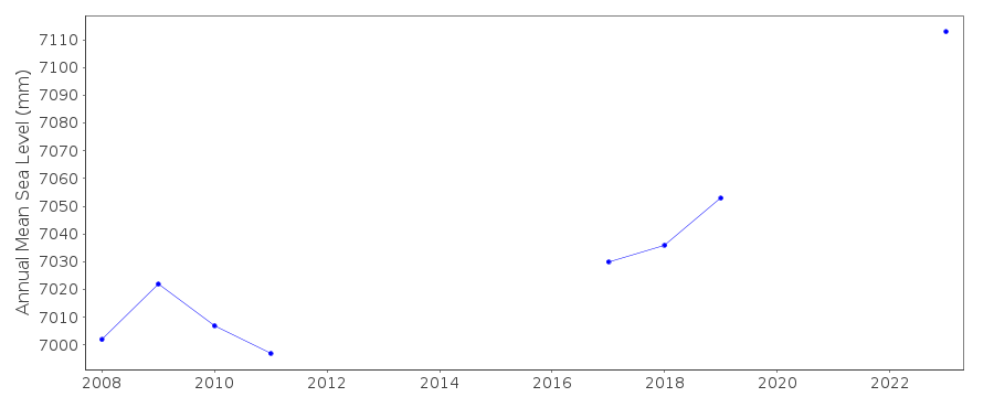 PSMSL Monthly Mean Sea Level for '2281' 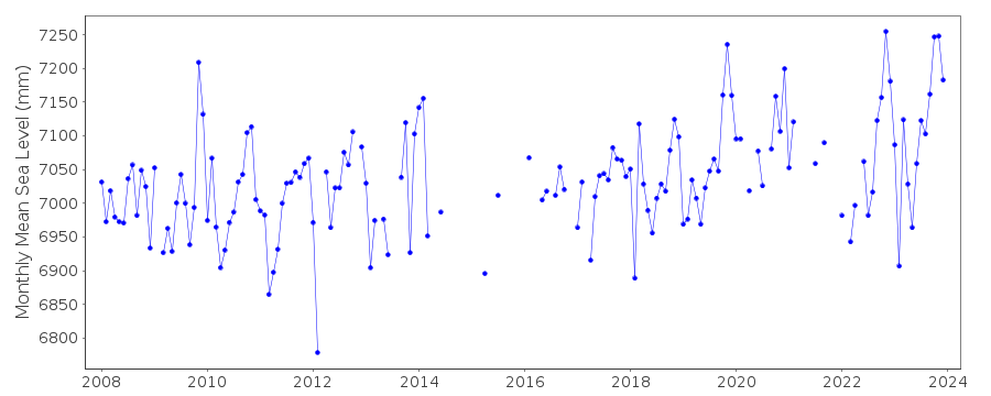
|
|
|