 |
SEALEVEL STATION CATALOG (SSC) |
|
|
|
|
|
| Station catalog metadata [edit] | [station overview] |
|---|
| SSC ID | SSC-zhap | | Station Name | Zhapo | | Country | China | | Latitude | 21.58333 | | Longitude | 111.83333 | | DateLastModified | 2015-10-22 19:02:29 |
| Distributed metadata source: IOC Sea Level Station Monitoring Facility zhap |
|---|
| GTS station code | 09731 |
| GTS message type | SZCI01 |
| Status | Operational |
| Local Contact | China Meteorological Administration ( China ) |
| Connection | GTS message |
| Country | China |
| Sensor 1 | |
| Type of sensor | rad |
| Sampling rate (min) | 1 |
| Distributed metadata source: GLOSS Station Handbook |
|---|
| Time Zone | 120E, GMT + 8hrs | | Ocean | Pacific | | Operational | Yes | | Data acquisition rate | Recording at hourly intervals | | Additional parameters | Surface T and S, wave and meteorological parameters | | Tide gauge benchmarks | TGBM (ZPZ8) is 5.9m to the corner of the nearer house in the north direction, 9.5m to the corner of a house in the east direction and 2.5m to the corner of a house in the west direction. | | Benchmark relationships | Tide Gauge Zero (TGZ) = 7.526m below ZPZ8.
TGZ = 1.366m below the MSL of the Yellow Sea (1956-old)
TGZ = 1.405m below the MSL of the Yellow Sea (1985-new)
TGZ = 4.554m below BM2
| | Auxiliary benchmarks | TBM is 43.2m from BM2.
BM2 is 26.8m from the SE corner of the old gauge well house and 19m to the north corner of the old wharf.
| | Other relevant codes | UHSLC 635 | | Nearest Met. station | Zhapo MS |
| Distributed metadata source: PTWC COMP META file |
| DCP ID | 09731 |
| WMO | SZCI01 |
| Samp Rate | 1 |
| Num# Samp | 1 |
| Unit | M |
| Scale | 1.0000 |
| Xmt Int. | 001 |
| Fst Min. | 0000 |
| HAR | 1 |
| Owner | CMA |
| Distributed metadata source: UHSLC |
| UHSLC id | 635 |
| SSC id | zhap |
| GLOSS id | 78 |
| UHSLC geojson | https://uhslc.soest.hawaii.edu/data/meta.geojson |
| Research quality data version a | 1975-01-01 - 1997-12-30 |
| RQ basin | pacific |
| Distributed metadata source: PSMSL |
| Name | ZHAPO |
| GLOSS id | 78 |
| UHSLC ID | 635 |
| Is RLR | Y |
| Has RLR Diagram | Y link |
| QC Flag | N |
| Old ID | 610/002 |
| Last Updated | 2025-03-27 |
| Supplier | NATIONAL MARINE DATA AND INFORMATION SERVICE (NMDIS) |
| Address | National Marine Data and Information Service (NMDIS), No. 93 Liuwei Road, Tianjin 300171, CHINA |
| Metric Start | 1959 |
| Metric End | 2024 |
| Metric Completeness | 98.9 |
| RLR Start | 1959 |
| RLR End | 2024 |
| RLR Completeness | 98.9 |
| Download metric sea level data. | Use only with extreme caution. |
IOC Sea Level Station Monitoring Facility - realtime graph for 'zhap' 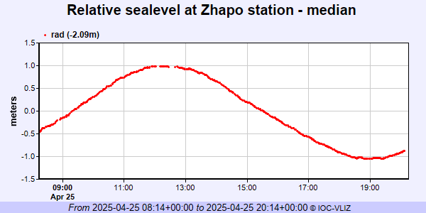 PSMSL Annual Mean Sea Level for '933' 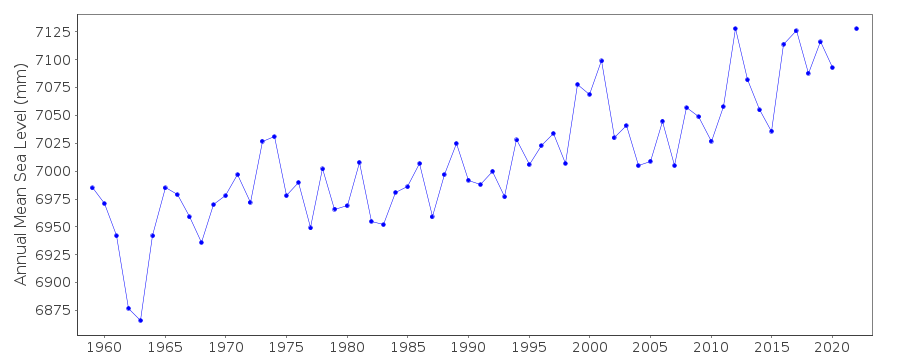 PSMSL Monthly Mean Sea Level for '933' 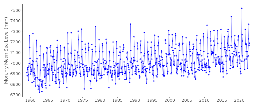
|
|
|