 |
SEALEVEL STATION CATALOG (SSC) |
|
|
|
|
|
| Station catalog metadata [edit] | [station overview] |
|---|
| SSC ID | SSC-zanz | | Station Name | Zanzibar | | Country | Tanzania | | Latitude | -6.15 | | Longitude | 39.1833 | | DateLastModified | 2015-10-22 19:02:29 |
| Distributed metadata source: IOC Sea Level Station Monitoring Facility zanz |
|---|
| GTS station code | 1605D3E0 |
| GTS message type | SXXX33 |
| Status | Down |
| Local Contact | Department of Land and Survey ( Tanzania ) |
| Other Contact | University of Hawaii Sea Level Center ( USA ) |
| Connection | GTS message |
| Country | Tanzania |
| Sensor 1 | |
| Type of sensor | prs |
| Sampling rate (min) | 1 |
| Sensor 2 | |
| Type of sensor | rad |
| Sampling rate (min) | 3 |
| Sensor 3 | |
| Type of sensor | enc |
| Sampling rate (min) | 5 |
| Sensor 4 | |
| Type of sensor | sw1 |
| Sampling rate (min) | 60 |
| Sensor 5 | |
| Type of sensor | sw2 |
| Sampling rate (min) | 60 |
| Sensor 6 | |
| Type of sensor | bat |
| Sampling rate (min) | 15 |
| Distributed metadata source: GLOSS Station Handbook |
|---|
| Time Zone | 045E, GMT + 3hrs | | Ocean | Indian | | Operational | Yes | | Responsible country | Tanzania | | Tide gauge benchmarks | Old TGBM - about 30.0m from tide gauge (521209E, 9319992N) | | Benchmark relationships | BMI at Malindi roundabout = 3.80m above Land Survey Datum (1984, 1987)
Mean Sea Level is 2.08m above Chart Datum
| | Auxiliary benchmarks | TGBM 1 is 3.709m above LSD
TGBM 2 is 3.750m above LSD
TGBM 3 is 3.925m above LSD
| | Other relevant information | Gauge re-located in Zanzibar Harbour during 1990. Daily values calculated using 119-point convolution filter (Bloomfield, 1976) centred on noon applied to the hourly data with respective periods of the 95, 50 and 5% amplitude points at 124.0, 60.2 and 40.2 hours. | | Other relevant codes | UHSLC 151 |
| Distributed metadata source: PTWC COMP META file |
| DCP ID | 1605D3E0 |
| WMO | SXXX33 |
| Samp Rate | 5 |
| Num# Samp | 6 |
| Unit | M |
| Scale | 1.0000 |
| Xmt Int. | 015 |
| Fst Min. | 0004 |
| HAR | 1 |
| Owner | UHSLC |
| Distributed metadata source: UHSLC |
| UHSLC id | 151 |
| SSC id | zanz |
| GLOSS id | 297 |
| UHSLC geojson | https://uhslc.soest.hawaii.edu/data/meta.geojson |
| Research quality data version a | 1984-03-02 - 2018-12-31 |
| RQ basin | indian |
| Fast delivery | 1984-03-02 - 2025-09-02 |
| Distributed metadata source: PSMSL |
| Name | ZANZIBAR |
| GLOSS id | 297 |
| UHSLC ID | 151 |
| SONEL id | 2615 |
| Is RLR | Y |
| Has RLR Diagram | Y link |
| QC Flag | N |
| Old ID | 460/016 |
| Last Updated | 2020-01-29 |
| Supplier | UNIVERSITY OF HAWAII SEA LEVEL CENTER |
| Address | University of Hawaii Sea Level Center, Department of Oceanography Division of Natural Sciences, 1000 Pope Road, Honolulu, Hawaii 96822, UNITED STATES |
| Metric Start | 1984 |
| Metric End | 2018 |
| Metric Completeness | 96.4 |
| RLR Start | 1984 |
| RLR End | 2018 |
| RLR Completeness | 96.4 |
| Download metric sea level data. | Use only with extreme caution. |
IOC Sea Level Station Monitoring Facility - realtime graph for 'zanz'  PSMSL Annual Mean Sea Level for '1600' 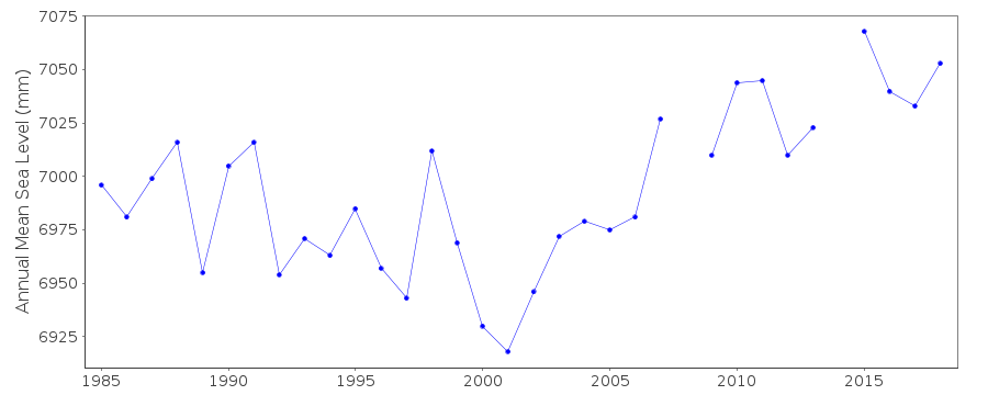 PSMSL Monthly Mean Sea Level for '1600' 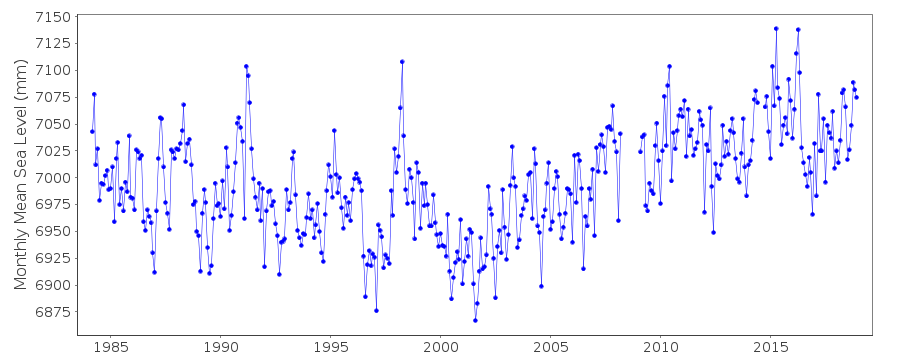
|
|
|