 |
SEALEVEL STATION CATALOG (SSC) |
|
|
|
|
|
| Station catalog metadata [edit] | [station overview] |
|---|
| SSC ID | SSC-yuzh | | Station Name | Yuzhno Kurilsk | | Country | Russia | | Latitude | 44.01666 | | Longitude | 145.86666 | | DateLastModified | 2015-10-22 19:02:29 |
| Linked codes |
|---|
| Codes | Location | Latitude | Longitude | Sensors | IOC: yuzh | Yuzhno-Kuril'sk | 44.04 | 145.85 | rad |
GLOSS: 90 | Yuzhno Kurilsk | 44.01666 | 145.86666 | Float |
PSMSL: 546 | YUZHNO KURILSK | 44.016667 | 145.866667 | N/A |
SONEL_TG: 2831 | YUZHNO KURILSK | 44.01666000 | 145.86666000 | N/A |
| Distributed metadata source: IOC Sea Level Station Monitoring Facility yuzh |
|---|
| Status | Down |
| Local Contact | Federal Service of Russia for Hydrometeorology and Environmental Monitoring ( Russia ) |
| Connection | WEB service |
| Country | Russia |
| Sensor 1 | |
| Type of sensor | rad |
| Sampling rate (min) | 1 |
| Distributed metadata source: GLOSS Station Handbook |
|---|
| Time Zone | 045E, GMT + 3hrs | | Ocean | Pacific | | Operational | Yes | | Responsible country | Russia | | Data acquisition rate | Hourly |
| Distributed metadata source: PSMSL |
| Name | YUZHNO KURILSK |
| GLOSS id | 90 |
| Is RLR | Y |
| Has RLR Diagram | Y link |
| QC Flag | N |
| Old ID | 630/001 |
| Last Updated | 1996-01-25 |
| Supplier | WORLD DATA CENTER B1 |
| Address | World Data Center , Russian Federal Service for Hydrometeorology, and Environmental Monitoring, 6 Korolev Street, 249035 Obninsk, Kaluga Region, RUSSIAN FEDERATION |
| Metric Start | 1948 |
| Metric End | 1994 |
| Metric Completeness | 95.0 |
| RLR Start | 1948 |
| RLR End | 1994 |
| RLR Completeness | 95.0 |
| Download metric sea level data. | Use only with extreme caution. |
IOC Sea Level Station Monitoring Facility - realtime graph for 'yuzh'  PSMSL Annual Mean Sea Level for '546'  PSMSL Monthly Mean Sea Level for '546' 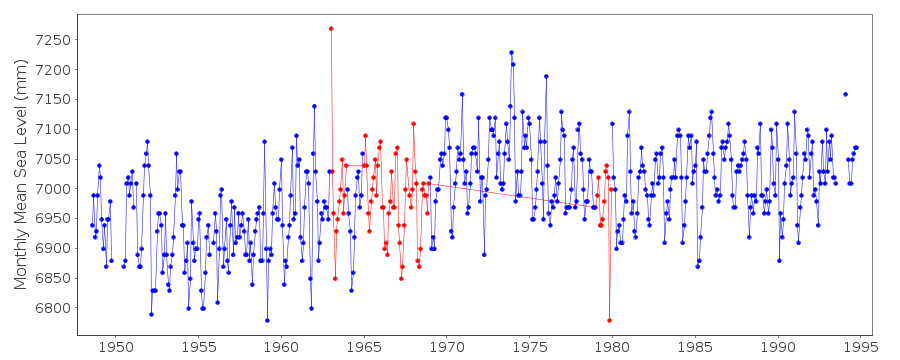
|
|
|