 |
SEALEVEL STATION CATALOG (SSC) |
|
|
|
|
|
| Station catalog metadata [edit] | [station overview] |
|---|
| SSC ID | SSC-xmas | | Station Name | Christmas Island | | Country | Kiribati | | Latitude | 1.984 | | Longitude | -157.473 | | DateLastModified | 2015-10-22 19:02:29 |
| Linked codes |
|---|
| Codes | Location | Latitude | Longitude | Sensors | IOC: xmas | Christmas_KI | 1.984 | -157.473 | prs, rad, ra2, bat, sw1, sw2, ra3 |
GLOSS: 146 | Christmas Is., Line Is. | 1.98333 | -157.48333 | Float |
UHSLC: 11 | Christmas | 1.982 | -157.472 | N/A |
PTWC: xmas | Christmas_KI | 1.9840 | -157.4730 | prs, ra2, ra3, rad |
PSMSL: 1371 | CHRISTMAS ISLAND II | 1.983333 | -157.483333 | N/A |
PSMSL: 801 | CHRISTMAS ISLAND | 1.983333 | -157.466667 | N/A |
SONEL_TG: 2848 | KIRITIMATI | 1.98400000 | -157.47300000 | N/A |
| Distributed metadata source: IOC Sea Level Station Monitoring Facility xmas |
|---|
| GTS station code | 301434060001890 |
| GTS message type | SZXX01 |
| Status | Operational |
| Local Contact | Kiribati Met Office ( Kiribati ) |
| Other Contact | University of Hawaii Sea Level Center ( USA ) |
| Connection | GTS message |
| Country | Kiribati |
| Sensor 1 | |
| Type of sensor | prs |
| Sampling rate (min) | 1 |
| Sensor 2 | |
| Type of sensor | rad |
| Sampling rate (min) | 1 |
| Sensor 3 | |
| Type of sensor | ra2 |
| Sampling rate (min) | 1 |
| Sensor 4 | |
| Type of sensor | bat |
| Sampling rate (min) | 5 |
| Sensor 5 | |
| Type of sensor | sw1 |
| Sampling rate (min) | 60 |
| Sensor 6 | |
| Type of sensor | sw2 |
| Sampling rate (min) | 60 |
| Sensor 7 | |
| Type of sensor | ra3 |
| Sampling rate (min) | 1 |
| Distributed metadata source: GLOSS Station Handbook |
|---|
| Time Zone | 150W, GMT - 10hrs | | Ocean | Pacific | | Operational | Yes | | Tide gauge benchmarks | UH-1: 1.25 inch SS disk with 'UH 1 1979' scribed in concrete base of tide house support, SW corner, 1ft from edge (established 10 Oct 1979) | | Auxiliary benchmarks | USGS 8: brass disk stamped 'Benchmark-USGS NO 8', SE corner of mechanical shop set in cement foundation 100 yd W of tide house (est. 1959)
USGS 17: brass disk stamped 'Benchmark-USGS NO 17' located at entrance of public works carpenter shop office (established 1959)
UH-XD: 1 inch square SS pin set in green epoxy, incised 'XD 90' located at boat shed, RH side of door (established 30 Oct 1990)
| | Other relevant information | Backup gauge on site: Handar encoder (Nov 1982-).
PSMSL also hold data from another gauge at Christmas Island (PSMSL Code 770/021 1956-1972).
Other benchmark: UH-XB 1 inch square SS pin set in green epoxy, incised 'XB 90', located at Public Works workshop, S corner, RH side of entry, 2ft from edge of building (established 30 Oct 1990)
| | Other relevant codes | UHSLC 011 |
| Distributed metadata source: PTWC COMP META file |
| DCP ID | 301434060001890 |
| WMO | SZXX01 |
| Samp Rate | 1 |
| Num# Samp | 5 |
| Unit | M |
| Scale | 1.0000 |
| Xmt Int. | 005 |
| Fst Min. | 0001 |
| HAR | 1 |
| Owner | UHSLC |
| Distributed metadata source: UHSLC |
| UHSLC id | 011 |
| SSC id | xmas |
| GLOSS id | 146 |
| UHSLC geojson | https://uhslc.soest.hawaii.edu/data/meta.geojson |
| Research quality data version a | 1955-12-02 - 1972-03-31 |
| Research quality data version b | 1974-02-07 - 2018-12-31 |
| RQ basin | pacific |
| Fast delivery | 1974-02-07 - 2025-12-20 |
| Distributed metadata source: PSMSL |
| Name | CHRISTMAS ISLAND II |
| GLOSS id | 146 |
| UHSLC ID | 11 |
| SONEL id | 4115 |
| Is RLR | Y |
| Has RLR Diagram | Y link |
| QC Flag | N |
| Old ID | 770/022 |
| Last Updated | 2020-01-28 |
| Supplier | UNIVERSITY OF HAWAII SEA LEVEL CENTER |
| Address | University of Hawaii Sea Level Center, Department of Oceanography Division of Natural Sciences, 1000 Pope Road, Honolulu, Hawaii 96822, UNITED STATES |
| Metric Start | 1974 |
| Metric End | 2018 |
| Metric Completeness | 91.7 |
| RLR Start | 1974 |
| RLR End | 2018 |
| RLR Completeness | 91.7 |
| Download metric sea level data. | Use only with extreme caution. |
| Name | CHRISTMAS ISLAND |
| GLOSS id | 146 |
| UHSLC ID | 11 |
| SONEL id | 4115 |
| Is RLR | Y |
| Has RLR Diagram | Y link |
| QC Flag | N |
| Old ID | 770/021 |
| Last Updated | null |
| Supplier | N.O.A.A. / N.O.S. |
| Address | N.O.A.A. / N.O.S., N/oes33, Ssmc4, Room 6531, 1305 East-West Highway, Silver Spring, , MD 20910, UNITED STATES |
| Metric Start | 1956 |
| Metric End | 1972 |
| Metric Completeness | 91.7 |
| RLR Start | 1956 |
| RLR End | 1972 |
| RLR Completeness | 91.7 |
| Download metric sea level data. | Use only with extreme caution. |
IOC Sea Level Station Monitoring Facility - realtime graph for 'xmas' 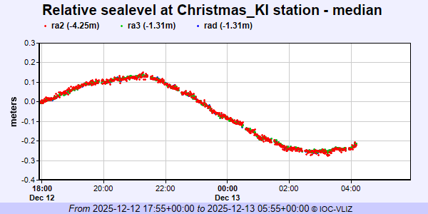 PSMSL Annual Mean Sea Level for '1371'  PSMSL Annual Mean Sea Level for '801' 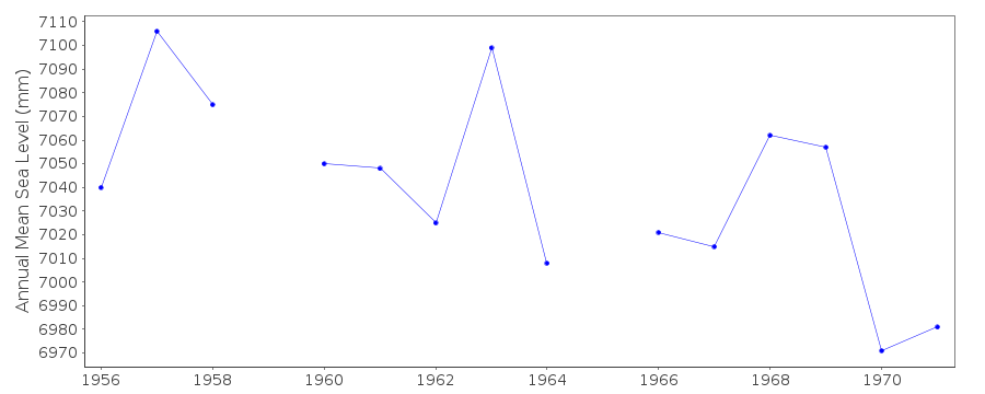 PSMSL Monthly Mean Sea Level for '801' 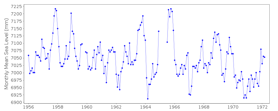
|
|
|