 |
SEALEVEL STATION CATALOG (SSC) |
|
|
|
|
|
| Station catalog metadata [edit] | [station overview] |
|---|
| SSC ID | SSC-wall | | Station Name | Mata-Utu (Wallis island) | | Country | France | | Latitude | -13.170479 | | Longitude | -176.100665 | | DateLastModified | 2015-10-22 19:02:29 |
| Linked codes |
|---|
| Codes | Location | Latitude | Longitude | Sensors | IOC: wall | Mata-Utu (Wallis island) | -13.285 | -176.17 | prs, rad, bat |
PTWC: wall | Wallis_Is_FR | -13.1705 | -176.1007 | prs, rad |
PSMSL: 383 | PORT WALLAROO | -33.933333 | 137.633333 | N/A |
SONEL_TG: 3472 | MATA'UTU | -13.28466900 | -176.16848500 | N/A |
| Distributed metadata source: IOC Sea Level Station Monitoring Facility wall |
|---|
| GTS station code | 0652170C |
| GTS message type | SZFW41 |
| Status | Operational |
| Local Contact | Service hydrographique et océanographique de la marine ( France ) |
| Other Contact | Service hydrographique et océanographique de la marine ( France ) |
| Connection | GTS message |
| Country | France |
| Sensor 1 | |
| Type of sensor | prs |
| Sampling rate (min) | 1 |
| Sensor 2 | |
| Type of sensor | rad |
| Sampling rate (min) | 1 |
| Sensor 3 | |
| Type of sensor | bat |
| Sampling rate (min) | 6 |
| Distributed metadata source: PTWC COMP META file |
| DCP ID | 0652170C |
| WMO | SZFW41 |
| Samp Rate | 1 |
| Num# Samp | 6 |
| Unit | M |
| Scale | 1.0000 |
| Xmt Int. | 006 |
| Fst Min. | 0004 |
| HAR | 1 |
| Owner | SHOM |
| Distributed metadata source: PSMSL |
| Name | PORT WALLAROO |
| Is RLR | Y |
| Has RLR Diagram | Y link |
| QC Flag | N |
| Old ID | 680/381 |
| Last Updated | null |
| Supplier | DEPT. OF MARINE AND HARBOURS, ADELAIDE |
| Address | Department of Marine and Harbours, Box 679e G.P.O., Adelaide, South Australia, AUSTRALIA |
| Metric Start | 1933 |
| Metric End | 1937 |
| Metric Completeness | 100.0 |
| RLR Start | 1933 |
| RLR End | 1937 |
| RLR Completeness | 100.0 |
| Download metric sea level data. | Use only with extreme caution. |
IOC Sea Level Station Monitoring Facility - realtime graph for 'wall' 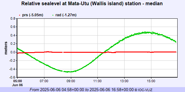 PSMSL Annual Mean Sea Level for '383' 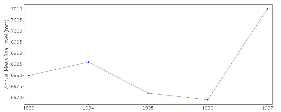 PSMSL Monthly Mean Sea Level for '383' 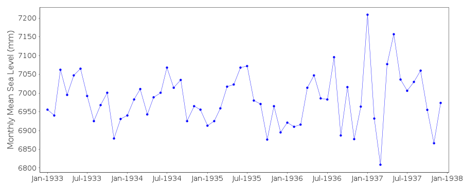
|
|
|