 |
SEALEVEL STATION CATALOG (SSC) |
|
|
|
|
|
| Station catalog metadata [edit] | [station overview] |
|---|
| SSC ID | SSC-viti | | Station Name | Suva_Viti_Levu | | Country | Fiji | | Latitude | -18.1342 | | Longitude | 178.4236 | | DateLastModified | 2015-10-22 19:02:29 |
| Distributed metadata source: IOC Sea Level Station Monitoring Facility viti |
|---|
| GTS station code | 67050 |
| GTS message type | SZPS01 |
| Status | Operational |
| Other Contact | National Tidal Centre/Australian Bureau of Meteorology ( Australia ) |
| Connection | GTS message |
| Country | Fiji Islands |
| Sensor 1 | |
| Type of sensor | aqu |
| Sampling rate (min) | 1 |
| Distributed metadata source: GLOSS Station Handbook |
|---|
| Time Zone | 180E, GMT + 12hrs | | Ocean | Pacific | | Operational | Yes | | Responsible country | Australia | | Data acquisition rate | Recorded at 6 minute intervals | | Additional parameters | Barometric pressure, wind speed & direction, air & water temperature | | Tide gauge benchmarks | NOS benchmark disk stamped '1 1989' set in concrete sea wall of the dockat Kings Wharf near the Ports Authority Office Building. | | Benchmark relationships | TGBM = 8.89 feet above mean lower low water (1960-1978 epoch)
TGBM = 6.64 feet above mean sea level (1960-1978 epoch)
TGBM = 4.71 feet above mean high water (1960-1978 epoch)
| | Auxiliary benchmarks | 2 1989 Screw 6 unstamped
3 1989 Screw 7 unstamped
4 1989 Screw 8 unstamped
5 1989
1-TG unstamped: brass screw inset in triangle 2ft S of tide house and 1.5 ft from edge of wharf
| | Other relevant information | A gauge was maintained on behalf of the TOGA Sea Level Center until it was withdrawn in May 1989 (PSMSL Code 742/013 1975-1989).
A gauge at Kings Wharf was destroyed in Nov 1983 and the station was relocated to Walu Bay Naval Facility (operated by Univ. Hawaii). There was an overlap of 3 months with the new NOAA gauge and the Walu gauge.
PSMSL also hold data from another gauge (PSMSL Code 742/011 1960-1961,1964).
NTF took over the gauge from NOAA in November 1997. | | Other relevant codes | NTF port no. 67050, UHSLC 018 | | Nearest Met. station | Laucala Bay, Suva |
| Distributed metadata source: PTWC COMP META file |
| DCP ID | |
| WMO | |
| Samp Rate | |
| Num# Samp | |
| Unit | |
| Scale | |
| Xmt Int. | |
| Fst Min. | |
| HAR | |
| Owner | |
| Distributed metadata source: UHSLC |
| UHSLC id | 018 |
| SSC id | viti |
| GLOSS id | 122 |
| UHSLC geojson | https://uhslc.soest.hawaii.edu/data/meta.geojson |
| Research quality data version a | 1972-10-01 - 1997-11-08 |
| Research quality data version b | 1998-01-27 - 2021-12-31 |
| RQ basin | pacific |
| Fast delivery | 1998-01-27 - 2026-01-31 |
| Distributed metadata source: PSMSL |
| Name | SUVA-A |
| GLOSS id | 122 |
| UHSLC ID | 18 |
| SONEL id | 849 |
| Is RLR | Y |
| Has RLR Diagram | Y link |
| QC Flag | N |
| Old ID | 742/012 |
| Last Updated | 2010-08-19 |
| Supplier | UNIVERSITY OF HAWAII SEA LEVEL CENTER |
| Address | University of Hawaii Sea Level Center, Department of Oceanography Division of Natural Sciences, 1000 Pope Road, Honolulu, Hawaii 96822, UNITED STATES |
| Metric Start | 1972 |
| Metric End | 1997 |
| Metric Completeness | 86.2 |
| RLR Start | 1972 |
| RLR End | 1997 |
| RLR Completeness | 86.2 |
| Download metric sea level data. | Use only with extreme caution. |
| Name | SUVA |
| GLOSS id | 122 |
| UHSLC ID | 18 |
| Is RLR | N |
| Has RLR Diagram | N link |
| QC Flag | N |
| Old ID | 742/011 |
| Last Updated | null |
| Supplier | HYDROGRAPHIC UNIT, FIJI |
| Address | Hydrographic Unit, Marine Department, Suva, FIJI |
| Metric Start | 1960 |
| Metric End | 1964 |
| Metric Completeness | 41.7 |
| Download metric sea level data. | Use only with extreme caution. |
IOC Sea Level Station Monitoring Facility - realtime graph for 'viti' 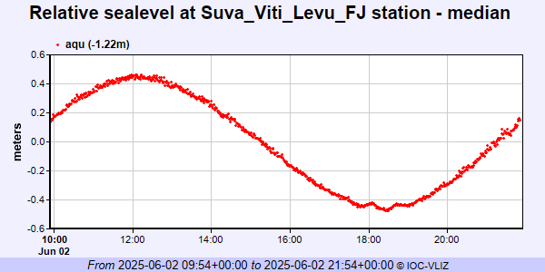 PSMSL Annual Mean Sea Level for '1327' 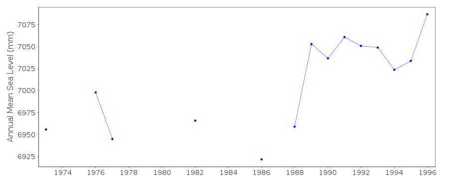 PSMSL Annual Mean Sea Level for '976'  PSMSL Monthly Mean Sea Level for '976' 
|
|
|