| Station catalog metadata [edit] | [station overview] |
|---|
| SSC ID | SSC-tjls |
| Station Name | Tanjung Lesung |
| Country | Indonesia |
| Latitude | -6.482941667 |
| Longitude | 105.6633556 |
| DateLastModified | 2015-10-22 19:02:29 |
| Linked codes |
|---|
| Codes | Location | Latitude | Longitude | Sensors |
IOC: tjls | Tanjung Lesung | -6.482941667 | 105.6633556 | rad, prs, pr2, bat |
IOC: tlbji | KEK Tanjung Lesung, Banten | -6.48 | 105.6592 | rad, bat |
UHSLC: 416 | Tanjung Lesung | -6.483 | 105.667 | N/A |
PTWC: tlbj | Tanjung_ID | -6.4800 | 105.6592 | rad |
SONEL_GPS: 2941 | TANJUNG LESUNG | -6.47765500 | 105.65782600 | N/A |
SONEL_TG: 2940 | TANJUNG LESUNG | -6.47765500 | 105.65782600 | N/A |
| Distributed metadata source: IOC Sea Level Station Monitoring Facility tjls |
|---|
| GTS message type | SXXX33 |
| Status | Down |
| Local Contact | Geospacial Agency of Indonesia ( Indonesia ) |
| Country | Indonesia |
| Sensor 1 | |
| Type of sensor | rad |
| Sampling rate (min) | 1 |
| Sensor 2 | |
| Type of sensor | prs |
| Sampling rate (min) | 1 |
| Sensor 3 | |
| Type of sensor | pr2 |
| Sampling rate (min) | 1 |
| Sensor 4 | |
| Type of sensor | bat |
| Sampling rate (min) | 15 |
| Distributed metadata source: IOC Sea Level Station Monitoring Facility tlbji |
|---|
| Status | Operational |
| Local Contact | Kepala Badan Meteorologi, Klimatologi, dan Geofisika ( Indonesia ) |
| Connection | WEB service |
| Country | Indonesia |
| Sensor 1 | |
| Type of sensor | rad |
| Sampling rate (min) | 1 |
| Sensor 2 | |
| Type of sensor | bat |
| Sampling rate (min) | 1 |
| Distributed metadata source: PTWC COMP META file |
| DCP ID | 1234AC00 |
| WMO | FTPI00 |
| Samp Rate | 1 |
| Num# Samp | 5 |
| Unit | m |
| Scale | 1.0000 |
| Xmt Int. | 005 |
| Fst Min. | 0000 |
| HAR | 0 |
| Owner | BKMG |
| Distributed metadata source: UHSLC |
| UHSLC id | 416 |
| SSC id | tjls |
| UHSLC geojson | https://uhslc.soest.hawaii.edu/data/meta.geojson |
| Fast delivery | 2008-01-31 - 2012-09-20 |
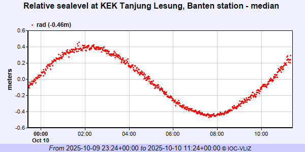
IOC Sea Level Station Monitoring Facility - realtime graph for 'tjls'
IOC Sea Level Station Monitoring Facility - realtime graph for 'tlbji'