| Station catalog metadata [edit] | [station overview] |
|---|
| SSC ID | SSC-tara | | Station Name | Betio | | Country | Kiribati | | Latitude | 1.3625 | | Longitude | 172.93 | | DateLastModified | 2015-10-22 19:02:29 |
| Distributed metadata source: IOC Sea Level Station Monitoring Facility tara |
|---|
| GTS station code | 67590 |
| GTS message type | SZPA01 |
| Status | Operational |
| Local Contact | Kiribati Met Office ( Kiribati ) |
| Other Contact | National Tidal Centre/Australian Bureau of Meteorology ( Australia ) |
| Connection | GTS message |
| Country | Kiribati |
| Sensor 1 | |
| Type of sensor | aqu |
| Sampling rate (min) | 1 |
| Distributed metadata source: GLOSS Station Handbook |
|---|
| Time Zone | 180E, GMT + 12hrs | | Ocean | Pacific | | Operational | Yes | | Responsible country | Australia | | Tide gauge benchmarks | BM1: SS bolt, no stamp, embedded in the concrete curb of the bulkhead directly above the tide staff (about 6ft west of the jetty)
(established December 1987)
| | Auxiliary benchmarks | BM2: SS bolt, no stamp, embedded in the concrete foundation of the memorial on the corner facing the jetty (established Dec 1987)
BM3: SS bolt, no stamp, embedded in the centre (4th) concrete buttress of the freezer plant wall which faces towards the lagoon
BM4: SS bolt, no stamp, embedded in the concrete foundation of the ice plant at the SW corner, facing the channel into the boat harbour
| | Other relevant information | Gauge located at 01deg 20N, 173deg 01E, 1973 - 1987 (Bairiki)
Gauge relocated to original location January 1988 (Betio)
Site A: PSMSL ref 730/006
Site B: PSMSL ref 730/007
Backup gauge at present site: Handar encoder
Additional benchmark, BM5: SS bolt embedded in the concrete porch on the SW corner of the National Fishing Company building, established Dec. 1990
An Aquatrak acoustic gauge was installed in 1992, at a slightly different location to the previous tide gauge. | | Other relevant codes | UHSLC 002 |
| Distributed metadata source: PTWC COMP META file |
| DCP ID | |
| WMO | |
| Samp Rate | |
| Num# Samp | |
| Unit | |
| Scale | |
| Xmt Int. | |
| Fst Min. | |
| HAR | |
| Owner | |
| Distributed metadata source: UHSLC |
| UHSLC id | 002 |
| SSC id | tara |
| GLOSS id | 113 |
| UHSLC geojson | https://uhslc.soest.hawaii.edu/data/meta.geojson |
| Research quality data version a | 1974-05-04 - 1983-12-30 |
| Research quality data version b | 1983-05-18 - 1988-05-09 |
| Research quality data version c | 1988-01-21 - 1997-12-31 |
| Research quality data version d | 1992-12-04 - 2021-12-31 |
| RQ basin | pacific |
| Fast delivery | 1992-12-04 - 2026-04-30 |
| Distributed metadata source: PSMSL |
| Name | TARAWA-A,BETIO |
| GLOSS id | 113 |
| UHSLC ID | 2 |
| SONEL id | 711 |
| Is RLR | Y |
| Has RLR Diagram | Y link |
| QC Flag | N |
| Old ID | 730/006 |
| Last Updated | 1990-08-29 |
| Supplier | UNIVERSITY OF HAWAII SEA LEVEL CENTER |
| Address | University of Hawaii Sea Level Center, Department of Oceanography Division of Natural Sciences, 1000 Pope Road, Honolulu, Hawaii 96822, UNITED STATES |
| Metric Start | 1974 |
| Metric End | 1983 |
| Metric Completeness | 73.3 |
| RLR Start | 1974 |
| RLR End | 1983 |
| RLR Completeness | 73.3 |
| Download metric sea level data. | Use only with extreme caution. |
| Name | TARAWA-B,BAIRIKI |
| GLOSS id | 113 |
| Is RLR | Y |
| Has RLR Diagram | Y link |
| QC Flag | Y |
| Old ID | 730/007 |
| Last Updated | 1990-11-15 |
| Supplier | UNIVERSITY OF HAWAII SEA LEVEL CENTER |
| Address | University of Hawaii Sea Level Center, Department of Oceanography Division of Natural Sciences, 1000 Pope Road, Honolulu, Hawaii 96822, UNITED STATES |
| Metric Start | 1983 |
| Metric End | 1988 |
| Metric Completeness | 79.2 |
| RLR Start | 1983 |
| RLR End | 1988 |
| RLR Completeness | 79.2 |
| Download metric sea level data. | Use only with extreme caution. |
| Name | TARAWA-C,BETIO |
| GLOSS id | 113 |
| UHSLC ID | 2 |
| SONEL id | 711 |
| Is RLR | Y |
| Has RLR Diagram | Y link |
| QC Flag | N |
| Old ID | 730/008 |
| Last Updated | 1998-12-31 |
| Supplier | UNIVERSITY OF HAWAII SEA LEVEL CENTER |
| Address | University of Hawaii Sea Level Center, Department of Oceanography Division of Natural Sciences, 1000 Pope Road, Honolulu, Hawaii 96822, UNITED STATES |
| Metric Start | 1988 |
| Metric End | 1997 |
| Metric Completeness | 99.2 |
| RLR Start | 1988 |
| RLR End | 1997 |
| RLR Completeness | 99.2 |
| Download metric sea level data. | Use only with extreme caution. |
| Name | BETIO |
| GLOSS id | 113 |
| UHSLC ID | 2 |
| SONEL id | 711 |
| Is RLR | Y |
| Has RLR Diagram | Y link |
| QC Flag | N |
| Old ID | 730/009 |
| Last Updated | 2026-06-01 |
| Supplier | NATIONAL TIDAL CENTRE |
| Address | National Tidal Centre, Bureau of Meteorology, PO Box 421, Kent Town 5071, South Australia, AUSTRALIA |
| Metric Start | 1992 |
| Metric End | 2026 |
| Metric Completeness | 91.9 |
| RLR Start | 1992 |
| RLR End | 2026 |
| RLR Completeness | 91.9 |
| Download metric sea level data. | Use only with extreme caution. |
IOC Sea Level Station Monitoring Facility - realtime graph for 'tara' 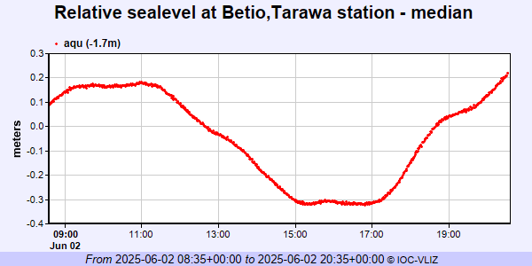 PSMSL Annual Mean Sea Level for '1381' 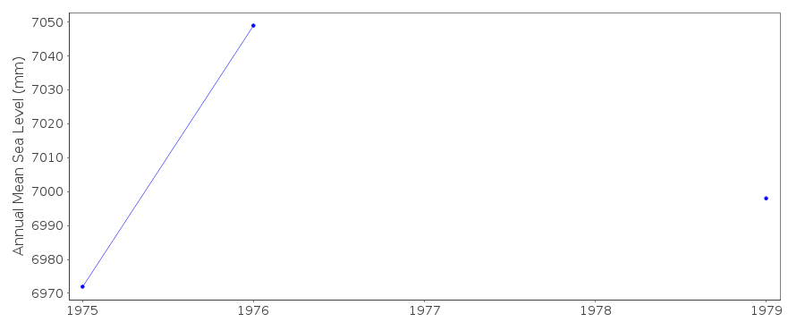 PSMSL Annual Mean Sea Level for '1579' 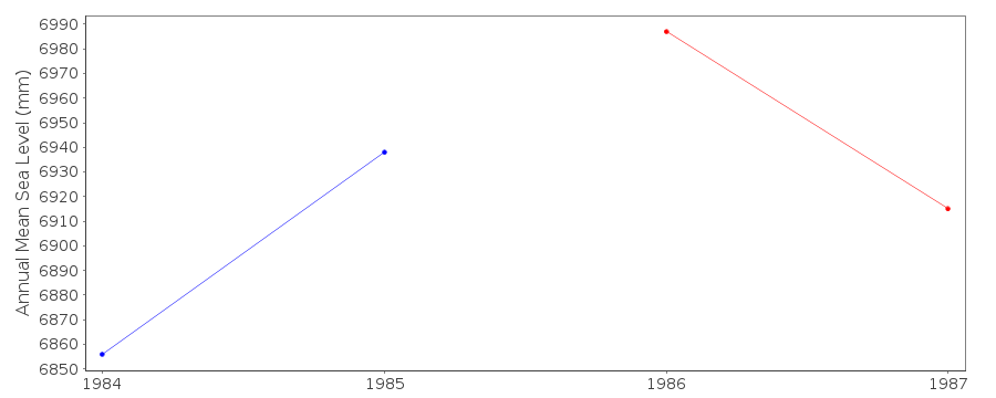 PSMSL Annual Mean Sea Level for '1739'  PSMSL Annual Mean Sea Level for '1804' 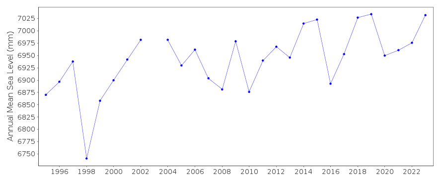 PSMSL Monthly Mean Sea Level for '1804' 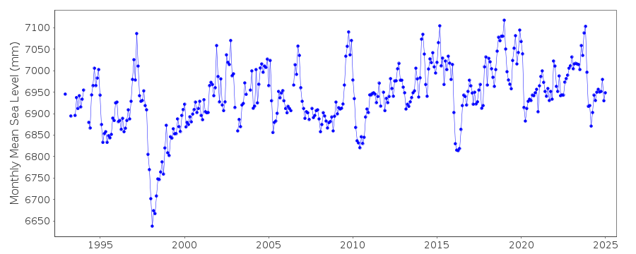
|
