 |
SEALEVEL STATION CATALOG (SSC) |
|
|
|
|
|
| Station catalog metadata [edit] | [station overview] |
|---|
| SSC ID | SSC-tako | | Station Name | Takoradi | | Country | Ghana | | Latitude | 4.8846 | | Longitude | -1.745 | | DateLastModified | 2015-10-22 19:02:29 |
| Distributed metadata source: IOC Sea Level Station Monitoring Facility tako |
|---|
| GTS station code | 26BF75DC |
| GTS message type | SXXX33 |
| Status | Down |
| Local Contact | Institut de Recherche pour le Développement ( France ) |
| Other Contact | OceanWise |
| Connection | GTS message |
| Country | Ghana |
| Sensor 1 | |
| Type of sensor | rad |
| Sampling rate (min) | 1 |
| Sensor 2 | |
| Type of sensor | pr1 |
| Sampling rate (min) | 1 |
| Sensor 3 | |
| Type of sensor | pr2 |
| Sampling rate (min) | 1 |
| Distributed metadata source: IOC Sea Level Station Monitoring Facility tkdi |
|---|
| GTS station code | 180022AA |
| GTS message type | SHGH01 |
| Status | Operational |
| Local Contact | OceanWise |
| Connection | FTP box |
| Country | Ghana |
| Sensor 1 | |
| Type of sensor | rad |
| Sampling rate (min) | 1 |
| Sensor 2 | |
| Type of sensor | prs |
| Sampling rate (min) | 1 |
| Sensor 3 | |
| Type of sensor | bat |
| Sampling rate (min) | 10 |
| Distributed metadata source: GLOSS Station Handbook |
|---|
| Responsible country | Ghana | | Additional parameters | The gauge at Takoradi GLOSS station is based on bottom- pressure measurements. Temperature output is provided and absolute pressure is sampled at 2Hz and averaged. | | Tide gauge benchmarks | TGBM GCS BM H4 Main Benchmark. Marker on tide gauge, close to radar mount | | Benchmark relationships | Chart Datum= 3.086m below TGBM GCS BM H4
Chart Datum= 3.292m below HB TAK3
Chart Datum= 3.357m below SG1
Chart Datum= 3.415m below SG2
Chart Datum= 3.297m below SGN1
Chart Datum= 6.067m below TKTG
Chart Datum= 4.179m below SGN9
Chart Datum= 24.943m below SGN3
Chart Datum= 25.042m below SGW346
Chart Datum= 28.288m below GPS 4C
Chart Datum= 30.427m below SGWH1
Chart Datum= 30.642m below SGN4
Chart Datum= 34.451m below GPS1_Roof | | Auxiliary benchmarks | HB TAK3 Benchmark roughly 10m to the right of the tide gauge
SG1 Benchmark roughly 10m to the left of the tide gauge
SG2 Near the TKTG GNSS station
SGN1 Between tide gauge and harbour entrance, close to a large building
TKTG Takoradi Tide Gauge GNSS station - 30m from tide gauge
SGN9 At harbour entrance
SGN3 On entrance of roundabout from the harbour
SGW346 In centre of Roundabout
GPS4C Auxiliary marker of TKRD, close to church
SGWH1 Pillar in front of Survey Department of Ghana office
SGN4 On left side of stairs of Survey Department of Ghana Office
GPS1_Roof Marker in roof near TKRD
GPS2_roof Marker in edge of roof of TKRD
TKRD GNSS station on roof of Survey Department of Ghana Office | | Other relevant information | Chart Datum= 34.427 m below GPS2_Roof
Chart Datum= 36.755m below TKRD
Data from the start of series until May 2009 refer to local Chart Datum. After this, the station was relocated. The station started operating again in January 2010, but to a different, yet to be established datum. |
| Distributed metadata source: PTWC COMP META file |
| DCP ID | |
| WMO | |
| Samp Rate | |
| Num# Samp | |
| Unit | |
| Scale | |
| Xmt Int. | |
| Fst Min. | |
| HAR | |
| Owner | |
| Distributed metadata source: UHSLC |
| UHSLC id | 231 |
| SSC id | tako |
| GLOSS id | 335 |
| UHSLC geojson | https://uhslc.soest.hawaii.edu/data/meta.geojson |
| Research quality data version a | 1983-01-01 - 1986-12-31 |
| Research quality data version b | 2004-07-02 - 2005-03-31 |
| Research quality data version c | 2007-01-05 - 2012-09-07 |
| RQ basin | atlantic |
| Fast delivery | 2007-01-05 - 2012-09-07 |
| Distributed metadata source: PSMSL |
| Name | TAKORADI |
| GLOSS id | 335 |
| UHSLC ID | 231 |
| Is RLR | Y |
| Has RLR Diagram | Y link |
| QC Flag | N |
| Old ID | 410/001 |
| Last Updated | 2013-03-15 |
| Supplier | SURVEY DEPT., ACCRA, GHANA |
| Address | Survey and Mapping Division, P.O. Box CT 903, Cantonments, Accra, GHANA |
| Metric Start | 1929 |
| Metric End | 2012 |
| Metric Completeness | 78.7 |
| RLR Start | 1929 |
| RLR End | 2012 |
| RLR Completeness | 78.7 |
| Download metric sea level data. | Use only with extreme caution. |
IOC Sea Level Station Monitoring Facility - realtime graph for 'tako'  IOC Sea Level Station Monitoring Facility - realtime graph for 'tkdi'  PSMSL Annual Mean Sea Level for '331'  PSMSL Monthly Mean Sea Level for '331' 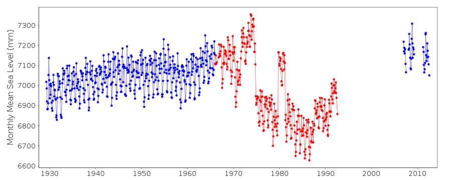
|
|
|