 |
SEALEVEL STATION CATALOG (SSC) |
|
|
|
|
|
| Station catalog metadata [edit] | [station overview] |
|---|
| SSC ID | SSC-sumt | | Station Name | Christchurch | | Country | New Zealand | | Latitude | -43.5696 | | Longitude | 172.7732 | | DateLastModified | 2015-10-22 19:02:29 |
| Distributed metadata source: IOC Sea Level Station Monitoring Facility sumt |
|---|
| GTS station code | SUMT |
| GTS message type | SZNZ01 |
| Status | Down |
| Local Contact | Land Information New Zealand ( New Zealand ) |
| Other Contact | EarthSciences NZ - GeoNet programme ( New Zealand ) |
| Connection | GTS message |
| Country | New Zealand |
| Sensor 1 | |
| Type of sensor | prs |
| Sampling rate (min) | 1 |
| Distributed metadata source: PTWC COMP META file |
| DCP ID | |
| WMO | |
| Samp Rate | |
| Num# Samp | |
| Unit | |
| Scale | |
| Xmt Int. | |
| Fst Min. | |
| HAR | |
| Owner | |
| Distributed metadata source: UHSLC |
| UHSLC id | 667 |
| SSC id | sumt |
| UHSLC geojson | https://uhslc.soest.hawaii.edu/data/meta.geojson |
| Research quality data version a | 1994-05-25 - 2024-12-30 |
| RQ basin | pacific |
| Distributed metadata source: PSMSL |
| Name | PORT LYTTELTON |
| UHSLC ID | 667 |
| SONEL id | 922 |
| Is RLR | Y |
| Has RLR Diagram | Y link |
| QC Flag | N |
| Old ID | 690/021 |
| Last Updated | 2026-02-17 |
| Supplier | LAND INFORMATION NEW ZEALAND (LINZ) |
| Address | Land Information New Zealand , 155 The Terrace, PO 5501, Wellington 6145, NEW ZEALAND |
| Metric Start | 1923 |
| Metric End | 2025 |
| Metric Completeness | 37.1 |
| RLR Start | 1923 |
| RLR End | 2025 |
| RLR Completeness | 37.1 |
| Download metric sea level data. | Use only with extreme caution. |
| Name | LYTTELTON II |
| UHSLC ID | 667 |
| SONEL id | 922 |
| Is RLR | Y |
| Has RLR Diagram | Y link |
| QC Flag | N |
| Old ID | 690/022 |
| Last Updated | 2003-01-17 |
| Supplier | DEPT. OF SURVEY AND LAND, N.Z. |
| Address | Department of Survey and Land Information, P.O. Box 170, Wellington, NEW ZEALAND |
| Metric Start | 1924 |
| Metric End | 2000 |
| Metric Completeness | 89.0 |
| RLR Start | 1924 |
| RLR End | 2000 |
| RLR Completeness | 89.0 |
| Download metric sea level data. | Use only with extreme caution. |
IOC Sea Level Station Monitoring Facility - realtime graph for 'sumt'  PSMSL Annual Mean Sea Level for '247'  PSMSL Annual Mean Sea Level for '259' 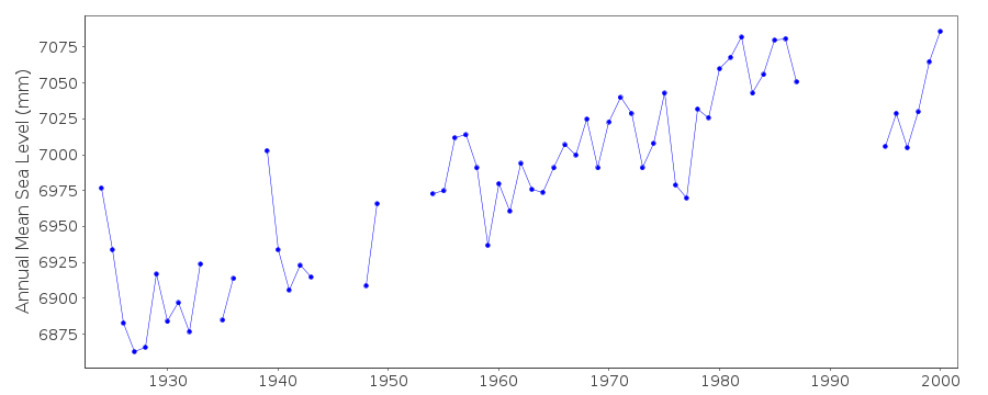 PSMSL Monthly Mean Sea Level for '259' 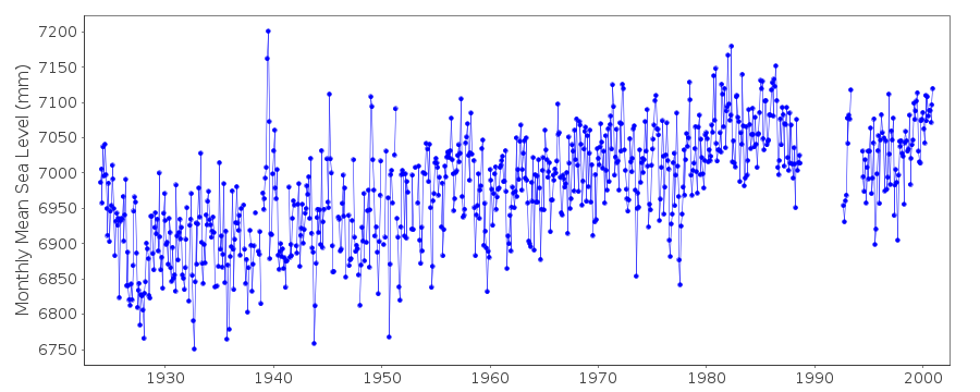
|
|
|