 |
SEALEVEL STATION CATALOG (SSC) |
|
|
|
|
|
| Station catalog metadata [edit] | [station overview] |
|---|
| SSC ID | SSC-stjo | | Station Name | St. Johns | | Country | Canada | | Latitude | 47.57 | | Longitude | -52.72 | | DateLastModified | 2015-10-22 19:02:29 |
| Distributed metadata source: IOC Sea Level Station Monitoring Facility stjo |
|---|
| Status | Operational |
| Local Contact | Fisheries and Oceans Canada ( Canada ) |
| Connection | WEB service |
| Country | Canada |
| Sensor 1 | |
| Type of sensor | enc |
| Sampling rate (min) | 1 |
| Distributed metadata source: GLOSS Station Handbook |
|---|
| Ocean | Atlantic | | Operational | Yes | | Responsible country | Canada | | Tide gauge benchmarks | 90F9000 A CHS tablet set vertically in the base of a concrete colonnade at the NE corner of the building of the Harvey Oil office. The building has a brick north face. The tablet is set into the top of the base 0.3m above the asphalt drive. | | Benchmark relationships | 1957 BM75K elevation 7.276m above Chart Datum (also see below)
1958-1959 BM HS elevation 7.276m above Chart Datum
1960-1979 BM77K elevation 3.602m above Chart Datum
1980-1987 BM77K elevation 3.602m above Chart Datum
| | Auxiliary benchmarks | 77K A GSC tablet set horizontally in the Canadian National Railway Station west wall, 1m north of the main entrance and 0.9m below a window.
87F9000 A CHS tablet set horizontally in the NE corner pillar of the auxiliary electrical building of the MOT complex.
Tablet 0.58m above concrete base & 0.18m west of the corner of the bldg. Elevation is 3.562m above Chart Datum.
| | Other relevant information | 1925-1937 Admiralty BM elevation 30.48m (Admiralty assumed datum)
** 1955-1956 BM76K elevation 7.154m above Chart Datum ** review pending
Auxiliary Benchmarks continued:
87F9001 A CHS tablet set vertically in a concrete guard post located on the west side of the 3rd loading door on the north side of the main depot bldg.Data available at http://www.waterlevels.gc.ca, http://www.meds-sdmm.dfo-mpo.gc.ca/meds/Databases/TWL/TWL_inventory_e.htm and http://www.meds-sdmm.dfo-mpo.gc.ca/meds/prog_nat/benchmark/public/default_e.as | | Other relevant codes | UHSLC 276 |
| Distributed metadata source: UHSLC |
| UHSLC id | 276 |
| SSC id | stjo |
| GLOSS id | 223 |
| UHSLC geojson | https://uhslc.soest.hawaii.edu/data/meta.geojson |
| Research quality data version a | 1935-08-03 - 1989-09-02 |
| Research quality data version b | 1989-09-03 - 2018-12-31 |
| RQ basin | atlantic |
| Fast delivery | 1989-09-03 - 2021-04-05 |
| Distributed metadata source: PSMSL |
| Name | ST. JOHN'S, NFLD. |
| GLOSS id | 223 |
| UHSLC ID | 276 |
| SONEL id | 3434 |
| Is RLR | Y |
| Has RLR Diagram | Y link |
| QC Flag | N |
| Old ID | 970/121 |
| Last Updated | 2025-06-19 |
| Supplier | CANADIAN HYDROGRAPHIC SERVICE |
| Address | Canadian Hydrographic Service, 615 Booth Street, Ottawa , Ontario K1A 0E6, CANADA |
| Metric Start | 1935 |
| Metric End | 2024 |
| Metric Completeness | 76.0 |
| RLR Start | 1935 |
| RLR End | 2024 |
| RLR Completeness | 76.0 |
| Download metric sea level data. | Use only with extreme caution. |
IOC Sea Level Station Monitoring Facility - realtime graph for 'stjo'  PSMSL Annual Mean Sea Level for '393' 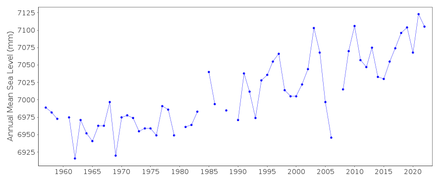 PSMSL Monthly Mean Sea Level for '393' 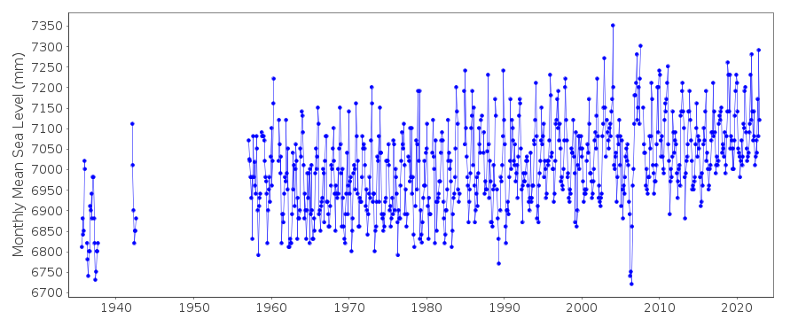
|
|
|