 |
SEALEVEL STATION CATALOG (SSC) |
|
|
|
|
|
| Station catalog metadata [edit] | [station overview] |
|---|
| SSC ID | SSC-sten | | Station Name | Stenhouse Bay | | Country | Australia | | Latitude | -35.25 | | Longitude | 137.766667 | | DateLastModified | 2015-10-22 19:02:29 |
| Linked codes |
|---|
| Codes | Location | Latitude | Longitude | Sensors | PSMSL: 492 | STENHOUSE BAY | -35.25 | 137.766667 | N/A |
| Distributed metadata source: PSMSL |
| Name | STENHOUSE BAY |
| Is RLR | Y |
| Has RLR Diagram | Y link |
| QC Flag | N |
| Old ID | 680/371 |
| Last Updated | null |
| Supplier | DEPT. OF MARINE AND HARBOURS, ADELAIDE |
| Address | Department of Marine and Harbours, Box 679e G.P.O., Adelaide, South Australia, AUSTRALIA |
| Metric Start | 1943 |
| Metric End | 1946 |
| Metric Completeness | 87.5 |
| RLR Start | 1944 |
| RLR End | 1946 |
| RLR Completeness | 83.3 |
| Download metric sea level data. | Use only with extreme caution. |
PSMSL Annual Mean Sea Level for '492'  PSMSL Monthly Mean Sea Level for '492' 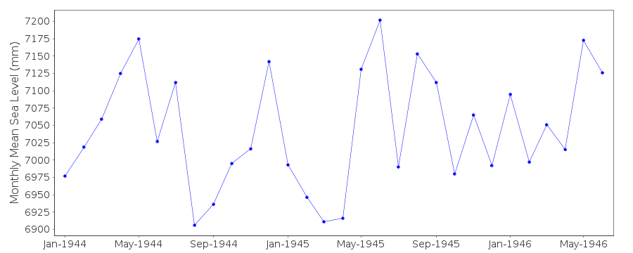
|
|
|