 |
SEALEVEL STATION CATALOG (SSC) |
|
|
|
|
|
| Station catalog metadata [edit] | [station overview] |
|---|
| SSC ID | SSC-solo | | Station Name | Honiara | | Country | Solomon Islands | | Latitude | -9.4289 | | Longitude | 159.9555 | | DateLastModified | 2015-10-22 19:02:29 |
| Distributed metadata source: IOC Sea Level Station Monitoring Facility solo |
|---|
| GTS station code | 56670 |
| GTS message type | SZPS01 |
| Status | Operational |
| Local Contact | National Tidal Centre/Australian Bureau of Meteorology ( Australia ) |
| Connection | GTS message |
| Country | Solomon Islands |
| Sensor 1 | |
| Type of sensor | aqu |
| Sampling rate (min) | 1 |
| Distributed metadata source: GLOSS Station Handbook |
|---|
| Time Zone | 165E, GMT + 11hrs | | Ocean | Pacific | | Operational | Yes | | Responsible country | Australia | | Data acquisition rate | 6 minute intervals | | Additional parameters | Barometric pressure, water and air temperature, wind speed and direction. | | Tide gauge benchmarks | MBM 001 a brass hexagonal bolt surmounted by a copper plate inscribed 'MBM 001 1981', set in concrete at the north east corner of the fuel compound of the Marine Division Building. | | Benchmark relationships | Tide Gauge Zero (TGZ) = 2.168m below TGBM
TGZ = 0.294m below Chart Datum
| | Auxiliary benchmarks | MBM 003 a brass hexagonal bolt surmounted by a copper plate inscribed 'MBM 003 1981', set in concrete at the north west corner of the Watchkeeper's Hut (Hut reported removed 1990).
MBM 004 a stainless hexagonal bolt set in squared concrete platform, situated at the west side of the Marine Divison flagpole.
| | Other relevant information | Backup gauge on site: Handar encoder (November 1984-)
PSMSL also hold data from 2 other gauges at Honiara (PSMSL Code 734/001 1957-1959, 1961 and PSMSL Code 734/003 1985-1987).
Daily values calculated using 119-point convolution filter (Bloomfield, 1976) centred on noon applied to the hourly data with respective periods of the 95, 50 and 5% amplitude points at 124.0, 60.2 and 40.2 hours.
| | Other relevant codes | NTF port no. 56670, UHSLC 009 | | Nearest Met. station | Honiara Meteorological Office |
| Distributed metadata source: PTWC COMP META file |
| DCP ID | 56670 |
| WMO | SZPS01 |
| Samp Rate | 1 |
| Num# Samp | 6 |
| Unit | M |
| Scale | 1.0000 |
| Xmt Int. | 003 |
| Fst Min. | 0000 |
| HAR | 1 |
| Owner | ABM |
| Distributed metadata source: UHSLC |
| UHSLC id | 009 |
| SSC id | solo |
| GLOSS id | 66 |
| UHSLC geojson | https://uhslc.soest.hawaii.edu/data/meta.geojson |
| Research quality data version a | 1974-11-21 - 1995-01-04 |
| Research quality data version b | 1994-07-28 - 2021-12-31 |
| RQ basin | pacific |
| Fast delivery | 1994-07-28 - 2026-04-30 |
| Distributed metadata source: PSMSL |
| Name | HONIARA II |
| GLOSS id | 66 |
| UHSLC ID | 9 |
| SONEL id | 2054 |
| Is RLR | Y |
| Has RLR Diagram | Y link |
| QC Flag | N |
| Old ID | 734/002 |
| Last Updated | 1996-11-07 |
| Supplier | UNIVERSITY OF HAWAII SEA LEVEL CENTER |
| Address | University of Hawaii Sea Level Center, Department of Oceanography Division of Natural Sciences, 1000 Pope Road, Honolulu, Hawaii 96822, UNITED STATES |
| Metric Start | 1974 |
| Metric End | 1994 |
| Metric Completeness | 93.3 |
| RLR Start | 1974 |
| RLR End | 1994 |
| RLR Completeness | 93.3 |
| Download metric sea level data. | Use only with extreme caution. |
| Name | HONIARA III |
| GLOSS id | 66 |
| UHSLC ID | 9 |
| Is RLR | N |
| Has RLR Diagram | N link |
| QC Flag | N |
| Old ID | 734/003 |
| Last Updated | 1993-05-24 |
| Supplier | NATIONAL TIDAL FACILITY |
| Address | National Tidal Facility, G.P.O. Box 2100, S.A. 5001, Adelaide , AUSTRALIA |
| Metric Start | 1985 |
| Metric End | 1987 |
| Metric Completeness | 100.0 |
| Download metric sea level data. | Use only with extreme caution. |
| Name | HONIARA-B |
| GLOSS id | 66 |
| UHSLC ID | 9 |
| SONEL id | 2054 |
| Is RLR | Y |
| Has RLR Diagram | Y link |
| QC Flag | N |
| Old ID | 734/004 |
| Last Updated | 2026-06-01 |
| Supplier | NATIONAL TIDAL CENTRE |
| Address | National Tidal Centre, Bureau of Meteorology, PO Box 421, Kent Town 5071, South Australia, AUSTRALIA |
| Metric Start | 1994 |
| Metric End | 2026 |
| Metric Completeness | 93.4 |
| RLR Start | 1994 |
| RLR End | 2026 |
| RLR Completeness | 93.4 |
| Download metric sea level data. | Use only with extreme caution. |
| Name | HONIARA |
| GLOSS id | 66 |
| UHSLC ID | 9 |
| Is RLR | N |
| Has RLR Diagram | N link |
| QC Flag | N |
| Old ID | 734/001 |
| Last Updated | null |
| Supplier | UNITED KINGDOM HYDROGRAPHIC OFFICE |
| Address | United Kingdom Hydrographic Office, Admiralty Way, Taunton, Somerset , TA1 2DN, UNITED KINGDOM |
| Metric Start | 1957 |
| Metric End | 1961 |
| Metric Completeness | 65.0 |
| Download metric sea level data. | Use only with extreme caution. |
IOC Sea Level Station Monitoring Facility - realtime graph for 'solo' 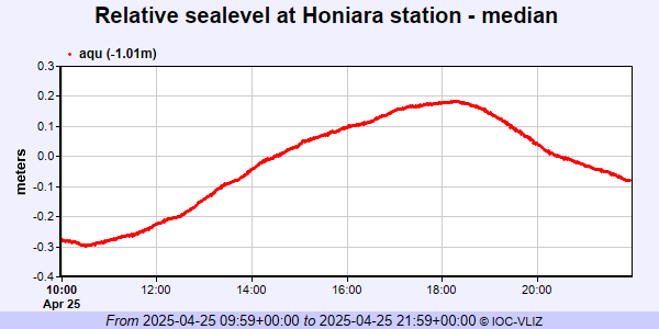 PSMSL Annual Mean Sea Level for '1373' 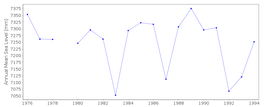 PSMSL Annual Mean Sea Level for '1667'  PSMSL Annual Mean Sea Level for '1861'  PSMSL Annual Mean Sea Level for '885'  PSMSL Monthly Mean Sea Level for '885' 
|
|
|