 |
SEALEVEL STATION CATALOG (SSC) |
|
|
|
|
|
| Station catalog metadata [edit] | [station overview] |
|---|
| SSC ID | SSC-sitt | | Station Name | Sittwe | | Country | Myanmar | | Latitude | 20.15 | | Longitude | 92.9 | | DateLastModified | 2015-10-22 19:02:29 |
| Distributed metadata source: IOC Sea Level Station Monitoring Facility sitt |
|---|
| GTS station code | 0650C490 |
| GTS message type | SZBM41 |
| Status | Down |
| Local Contact | Department of Meteorology and Hydrology ( Myanmar ) |
| Other Contact | University of Hawaii Sea Level Center ( USA ) |
| Connection | GTS message |
| Country | Myanmar |
| Sensor 1 | |
| Type of sensor | prs |
| Sampling rate (min) | 1 |
| Sensor 2 | |
| Type of sensor | rad |
| Sampling rate (min) | 1 |
| Sensor 3 | |
| Type of sensor | ra2 |
| Sampling rate (min) | 3 |
| Sensor 4 | |
| Type of sensor | sw1 |
| Sampling rate (min) | 60 |
| Sensor 5 | |
| Type of sensor | enc |
| Sampling rate (min) | 6 |
| Sensor 6 | |
| Type of sensor | sw2 |
| Sampling rate (min) | 60 |
| Sensor 7 | |
| Type of sensor | bat |
| Sampling rate (min) | 6 |
| Distributed metadata source: GLOSS Station Handbook |
|---|
| Ocean | Indian | | Operational | Yes | | Responsible country | Myanmar | | Tide gauge benchmarks | Benchmark in portico of Marine Office | | Benchmark relationships | Admiralty Chart Datum (ACD) is 5m below Port Survey Datum (PSD) |
| Distributed metadata source: PTWC COMP META file |
| DCP ID | 0650C490 |
| WMO | SZBM41 |
| Samp Rate | 6 |
| Num# Samp | 3 |
| Unit | M |
| Scale | 1.0000 |
| Xmt Int. | 006 |
| Fst Min. | 0000 |
| HAR | 1 |
| Owner | UHSLC |
| Distributed metadata source: UHSLC |
| UHSLC id | 907 |
| SSC id | sitt |
| GLOSS id | 37 |
| UHSLC geojson | https://uhslc.soest.hawaii.edu/data/meta.geojson |
| Research quality data version a | 2006-09-08 - 2018-12-31 |
| RQ basin | indian |
| Fast delivery | 2006-09-08 - 2025-09-02 |
| Distributed metadata source: PSMSL |
| Name | AKYAB II |
| UHSLC ID | 907 |
| Is RLR | N |
| Has RLR Diagram | N link |
| QC Flag | N |
| Old ID | 530/002 |
| Last Updated | 2015-10-28 |
| Supplier | UNIVERSITY OF HAWAII SEA LEVEL CENTER |
| Address | University of Hawaii Sea Level Center, Department of Oceanography Division of Natural Sciences, 1000 Pope Road, Honolulu, Hawaii 96822, UNITED STATES |
| Metric Start | 2006 |
| Metric End | 2014 |
| Metric Completeness | 53.7 |
| Download metric sea level data. | Use only with extreme caution. |
| Name | SITTWE (AKYAB) |
| GLOSS id | 37 |
| UHSLC ID | 907 |
| Is RLR | Y |
| Has RLR Diagram | Y link |
| QC Flag | N |
| Old ID | 530/003 |
| Last Updated | 2023-03-07 |
| Supplier | UNIVERSITY OF HAWAII SEA LEVEL CENTER |
| Address | University of Hawaii Sea Level Center, Department of Oceanography Division of Natural Sciences, 1000 Pope Road, Honolulu, Hawaii 96822, UNITED STATES |
| Metric Start | 2006 |
| Metric End | 2018 |
| Metric Completeness | 60.3 |
| RLR Start | 2006 |
| RLR End | 2018 |
| RLR Completeness | 60.3 |
| Download metric sea level data. | Use only with extreme caution. |
| Name | AKYAB |
| GLOSS id | 37 |
| UHSLC ID | 907 |
| Is RLR | Y |
| Has RLR Diagram | Y link |
| QC Flag | N |
| Old ID | 530/001 |
| Last Updated | null |
| Supplier | SURVEY OF INDIA |
| Address | Survey of India, Geodetic and Research Branch, 17 E.C. Road, Dehra Dun , PIN 248 001, INDIA |
| Metric Start | 1937 |
| Metric End | 1942 |
| Metric Completeness | 86.1 |
| RLR Start | 1937 |
| RLR End | 1942 |
| RLR Completeness | 86.1 |
| Download metric sea level data. | Use only with extreme caution. |
IOC Sea Level Station Monitoring Facility - realtime graph for 'sitt'  PSMSL Annual Mean Sea Level for '2270'  PSMSL Annual Mean Sea Level for '2275' 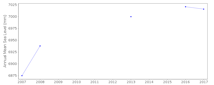 PSMSL Annual Mean Sea Level for '421' 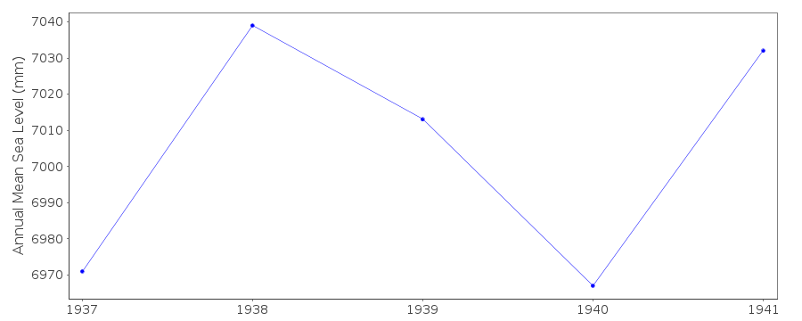 PSMSL Monthly Mean Sea Level for '421' 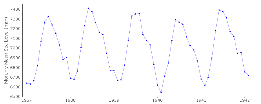
|
|
|