 |
SEALEVEL STATION CATALOG (SSC) |
|
|
|
|
|
| Station catalog metadata [edit] | [station overview] |
|---|
| SSC ID | SSC-sete | | Station Name | Sète | | Country | France | | Latitude | 43.3976 | | Longitude | 3.69911 | | DateLastModified | 2015-10-22 19:02:29 |
| Distributed metadata source: IOC Sea Level Station Monitoring Facility sete |
|---|
| Status | Operational |
| Local Contact | Service hydrographique et océanographique de la marine ( France ) |
| Connection | FTP box |
| Country | France |
| Sensor 1 | |
| Type of sensor | rad |
| Sampling rate (min) | 1 |
| Distributed metadata source: IOC Sea Level Station Monitoring Facility sete2 |
|---|
| GTS station code | FR250 |
| GTS message type | SZFR01 |
| Status | Operational |
| Local Contact | Service hydrographique et océanographique de la marine ( France ) |
| Connection | GTS message |
| Country | France |
| Sensor 1 | |
| Type of sensor | rad |
| Sampling rate (min) | 1 |
| Distributed metadata source: PTWC COMP META file |
| DCP ID | 18F6C382 |
| WMO | SZFR01 |
| Samp Rate | 1 |
| Num# Samp | 12 |
| Unit | M |
| Scale | 1.0000 |
| Xmt Int. | 006 |
| Fst Min. | 0000 |
| HAR | 1 |
| Owner | SHOM |
| Distributed metadata source: PSMSL |
| Name | SETE |
| SONEL id | 1905 |
| Is RLR | Y |
| Has RLR Diagram | Y link |
| QC Flag | N |
| Old ID | 230/021 |
| Last Updated | 2026-02-20 |
| Supplier | SERVICE HYD. ET OCEAN. DE LA MARINE |
| Address | SHOM, 13 rue de Chatelier, 29200 BREST , FRANCE |
| Metric Start | 1960 |
| Metric End | 2025 |
| Metric Completeness | 50.0 |
| RLR Start | 1992 |
| RLR End | 2025 |
| RLR Completeness | 86.5 |
| Download metric sea level data. | Use only with extreme caution. |
IOC Sea Level Station Monitoring Facility - realtime graph for 'sete' 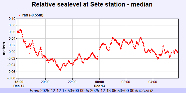 IOC Sea Level Station Monitoring Facility - realtime graph for 'sete2'  PSMSL Annual Mean Sea Level for '958' 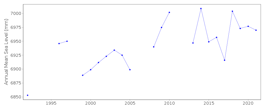 PSMSL Monthly Mean Sea Level for '958' 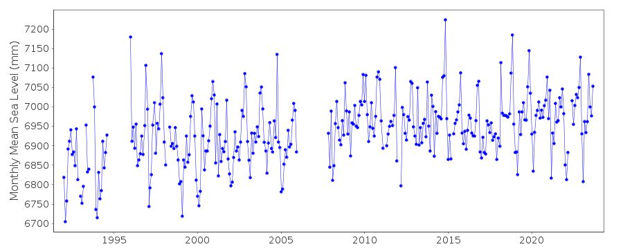
|
|
|