 |
SEALEVEL STATION CATALOG (SSC) |
|
|
|
|
|
| Station catalog metadata [edit] | [station overview] |
|---|
| SSC ID | SSC-sdpt | | Station Name | Sand Point, Popof Island | | Country | United States | | Latitude | 55.3367 | | Longitude | -160.5017 | | DateLastModified | 2015-10-22 19:02:29 |
| Linked codes |
|---|
| Codes | Location | Latitude | Longitude | Sensors | IOC: sdpt | Sand_Point_AK | 55.3367 | -160.5017 | wls |
IOC: sdpt2 | Sand_Point_AK | 55.3367 | -160.5017 | pwl |
GLOSS: 100 | Sand Point, AK | 55.33333 | -160.5 | Float, Pressure, Bubbler, Acoustic |
UHSLC: 574 | Sand Point, AK | 55.337 | -160.502 | N/A |
PTWC: sdpt | Sand_Point_AK | 55.3317 | -160.5040 | pwc, pwl, bwl |
PSMSL: 1634 | SAND POINT, POPOF IS., AK | 55.336667 | -160.501667 | N/A |
SONEL_GPS: 2669 | SAND POINT | 55.34927600 | -160.47675700 | N/A |
SONEL_TG: 2668 | SAND POINT | 55.33182900 | -160.50367200 | N/A |
| Distributed metadata source: IOC Sea Level Station Monitoring Facility sdpt |
|---|
| GTS station code | 33602066 |
| GTS message type | SXXX03 |
| Status | Operational |
| Local Contact | National Ocean Service-NOAA ( USA ) |
| Connection | WEB service |
| Country | USA |
| Sensor 1 | |
| Type of sensor | wls |
| Sampling rate (min) | 1 |
| Distributed metadata source: IOC Sea Level Station Monitoring Facility sdpt2 |
|---|
| GTS station code | 33602066 |
| GTS message type | SXXX03 |
| Status | Operational |
| Local Contact | National Ocean Service-NOAA ( USA ) |
| Connection | GTS message |
| Country | USA |
| Sensor 1 | |
| Type of sensor | pwl |
| Sampling rate (min) | 1 |
| Distributed metadata source: GLOSS Station Handbook |
|---|
| Time Zone | 135W, GMT - 9hrs | | Ocean | Pacific | | Operational | Yes | | Data acquisition rate | 6 minute intervals | | Tide gauge benchmarks | US C&GS tidal benchmark survey disk stamped '5 1943' set in a boulder near the Trident Seafood Corporation machine shop at Sand Point, Popof Island, AK. | | Benchmark relationships | TGBM = 18.15 feet above mean lower low water (1960-1978 epoch)
TGBM = 14.32 feet above mean sea level (1960-1978 epoch)
TGBM = 11.67 feet above mean high water (1960-1978 epoch)
| | Auxiliary benchmarks | 3 1943 9450 L 1982 NO 6 1950
'Standard Disc' 9450 K 1982 NO 7 1950
NO 8 1953 NO 9 1954
Site inspection 1993 states 'all levels agree with history'
| | Other relevant information | Intermittent observations at this site: 1913, 1943, 1950-1955, 1964 | | Other relevant codes | UHSLC 574 |
| Distributed metadata source: PTWC COMP META file |
| DCP ID | 33602066 |
| WMO | SXXX03 |
| Samp Rate | 6 |
| Num# Samp | 1 |
| Unit | M |
| Scale | 1.3674 |
| Xmt Int. | 006 |
| Fst Min. | 0000 |
| HAR | 1 |
| Owner | NOS |
| Distributed metadata source: UHSLC |
| UHSLC id | 574 |
| SSC id | sdpt |
| GLOSS id | 100 |
| UHSLC geojson | https://uhslc.soest.hawaii.edu/data/meta.geojson |
| Research quality data version a | 1972-09-11 - 2022-12-31 |
| RQ basin | pacific |
| Fast delivery | 1972-09-11 - 2026-04-30 |
| Distributed metadata source: PSMSL |
| Name | SAND POINT, POPOF IS., AK |
| GLOSS id | 100 |
| UHSLC ID | 574 |
| SONEL id | 2669 |
| Is RLR | Y |
| Has RLR Diagram | Y link |
| QC Flag | N |
| Old ID | 821/006 |
| Last Updated | 2024-01-10 |
| Supplier | N.O.A.A. / N.O.S. |
| Address | N.O.A.A. / N.O.S., N/oes33, Ssmc4, Room 6531, 1305 East-West Highway, Silver Spring, , MD 20910, UNITED STATES |
| Metric Start | 1985 |
| Metric End | 2023 |
| Metric Completeness | 99.1 |
| RLR Start | 1985 |
| RLR End | 2023 |
| RLR Completeness | 99.1 |
| Download metric sea level data. | Use only with extreme caution. |
IOC Sea Level Station Monitoring Facility - realtime graph for 'sdpt' 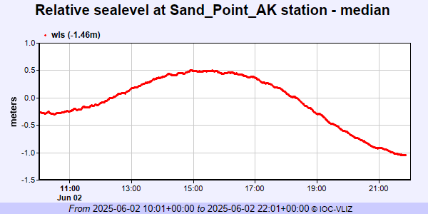 IOC Sea Level Station Monitoring Facility - realtime graph for 'sdpt2' 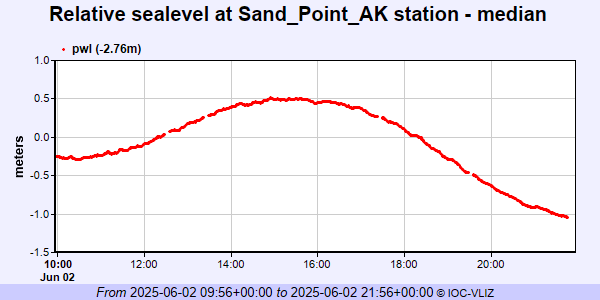 PSMSL Annual Mean Sea Level for '1634' 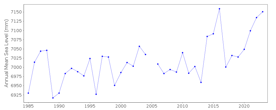 PSMSL Monthly Mean Sea Level for '1634' 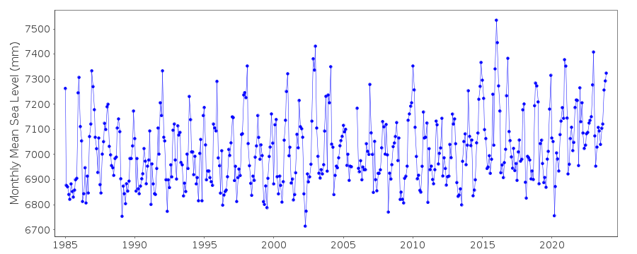
|
|
|