 |
SEALEVEL STATION CATALOG (SSC) |
|
|
|
|
|
| Station catalog metadata [edit] | [station overview] |
|---|
| SSC ID | SSC-sanfw | | Station Name | San Fernando, La Union | | Country | Philippines | | Latitude | 16.616667 | | Longitude | 120.3 | | DateLastModified | 2015-10-22 19:02:29 |
| Linked codes |
|---|
| Codes | Location | Latitude | Longitude | Sensors | PSMSL: 548 | SAN FERNANDO, LA UNION | 16.616667 | 120.3 | N/A |
| Distributed metadata source: PSMSL |
| Name | SAN FERNANDO, LA UNION |
| Is RLR | Y |
| Has RLR Diagram | Y link |
| QC Flag | N |
| Old ID | 660/001 |
| Last Updated | 2025-06-18 |
| Supplier | NATIONAL MAPPING AND RESOURCE INFORMATION AUTHORITY |
| Address | National Mapping and Resource Information Authority, Hydrography Department, 421 Barraca St,, San Nicolas 1010, Manila , PHILIPPINES |
| Metric Start | 1948 |
| Metric End | 2024 |
| Metric Completeness | 9.0 |
| RLR Start | 1948 |
| RLR End | 2024 |
| RLR Completeness | 9.0 |
| Download metric sea level data. | Use only with extreme caution. |
PSMSL Annual Mean Sea Level for '548' 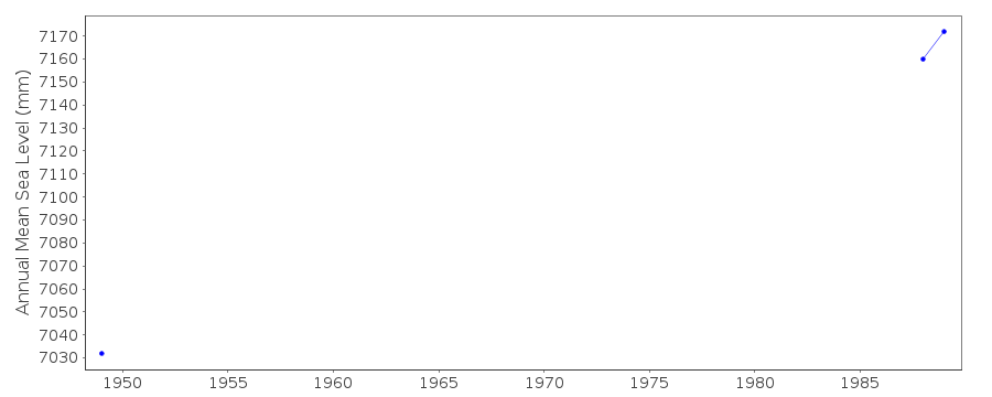 PSMSL Monthly Mean Sea Level for '548' 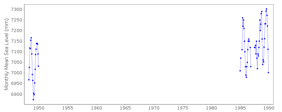
|
|
|