 |
SEALEVEL STATION CATALOG (SSC) |
|
|
|
|
|
| Station catalog metadata [edit] | [station overview] |
|---|
| SSC ID | SSC-saip | | Station Name | Saipan | | Country | United States | | Latitude | 15.2266 | | Longitude | 145.7416 | | DateLastModified | 2015-10-22 19:02:29 |
| Linked codes |
|---|
| Codes | Location | Latitude | Longitude | Sensors | IOC: saip | Saipan_US | 15.2266 | 145.7416 | prs, rad, ra2, sw1, sw2, bat |
GLOSS: 118 | Saipan | 15.23333 | 145.73333 | Float, Pressure, Acoustic |
UHSLC: 28 | Saipan | 15.227 | 145.742 | N/A |
PTWC: saip | Saipan_US | 15.2266 | 145.7416 | prs, ra2, rad |
PSMSL: 1474 | SAIPAN | 15.233333 | 145.75 | N/A |
SONEL_GPS: 1873 | MARIANA ISLAND | 15.22969723 | 145.74308777 | N/A |
SONEL_TG: 2145 | MARIANA ISLAND | 15.23300000 | 145.75000000 | N/A |
| Distributed metadata source: IOC Sea Level Station Monitoring Facility saip |
|---|
| GTS station code | 300434066941730 |
| GTS message type | SZXX01 |
| Status | Down |
| Local Contact | Office of the Port Director ( Northern Marianas, USA ) |
| Other Contact | University of Hawaii Sea Level Center ( USA ) |
| Connection | GTS message |
| Country | USA |
| Sensor 1 | |
| Type of sensor | prs |
| Sampling rate (min) | 1 |
| Sensor 2 | |
| Type of sensor | rad |
| Sampling rate (min) | 1 |
| Sensor 3 | |
| Type of sensor | ra2 |
| Sampling rate (min) | 1 |
| Sensor 4 | |
| Type of sensor | sw1 |
| Sampling rate (min) | 60 |
| Sensor 5 | |
| Type of sensor | sw2 |
| Sampling rate (min) | 60 |
| Sensor 6 | |
| Type of sensor | bat |
| Sampling rate (min) | 5 |
| Distributed metadata source: GLOSS Station Handbook |
|---|
| Time Zone | 150E, GMT + 10hrs | | Ocean | Pacific | | Operational | Yes | | Other relevant information | Daily values calculated using 119-point convolution filter (Bloomfield, 1976) centred on noon applied to the hourly data with respective periods of the 95, 50 and 5% amplitude points at 124.0, 60.2 and 40.2 hours. | | Other relevant codes | UHSLC 028 |
| Distributed metadata source: PTWC COMP META file |
| DCP ID | 300434066941730 |
| WMO | SZXX01 |
| Samp Rate | 5 |
| Num# Samp | 5 |
| Unit | M |
| Scale | 1.0000 |
| Xmt Int. | 005 |
| Fst Min. | 0001 |
| HAR | 1 |
| Owner | UHSLC |
| Distributed metadata source: UHSLC |
| UHSLC id | 028 |
| SSC id | saip |
| GLOSS id | 118 |
| UHSLC geojson | https://uhslc.soest.hawaii.edu/data/meta.geojson |
| Research quality data version a | 1938-03-03 - 1940-03-19 |
| Research quality data version b | 1978-09-19 - 2018-12-31 |
| RQ basin | pacific |
| Fast delivery | 1978-09-19 - 2026-04-13 |
| Distributed metadata source: PSMSL |
| Name | SAIPAN |
| GLOSS id | 118 |
| UHSLC ID | 28 |
| SONEL id | 1873 |
| Is RLR | Y |
| Has RLR Diagram | Y link |
| QC Flag | Y |
| Old ID | 700/011 |
| Last Updated | 2020-01-29 |
| Supplier | UNIVERSITY OF HAWAII SEA LEVEL CENTER |
| Address | University of Hawaii Sea Level Center, Department of Oceanography Division of Natural Sciences, 1000 Pope Road, Honolulu, Hawaii 96822, UNITED STATES |
| Metric Start | 1978 |
| Metric End | 2018 |
| Metric Completeness | 88.0 |
| RLR Start | 1978 |
| RLR End | 2018 |
| RLR Completeness | 88.0 |
| Download metric sea level data. | Use only with extreme caution. |
IOC Sea Level Station Monitoring Facility - realtime graph for 'saip' 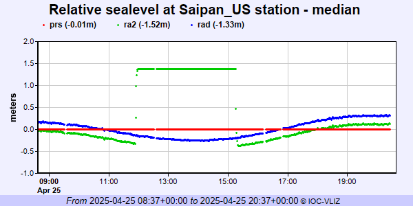 PSMSL Annual Mean Sea Level for '1474' 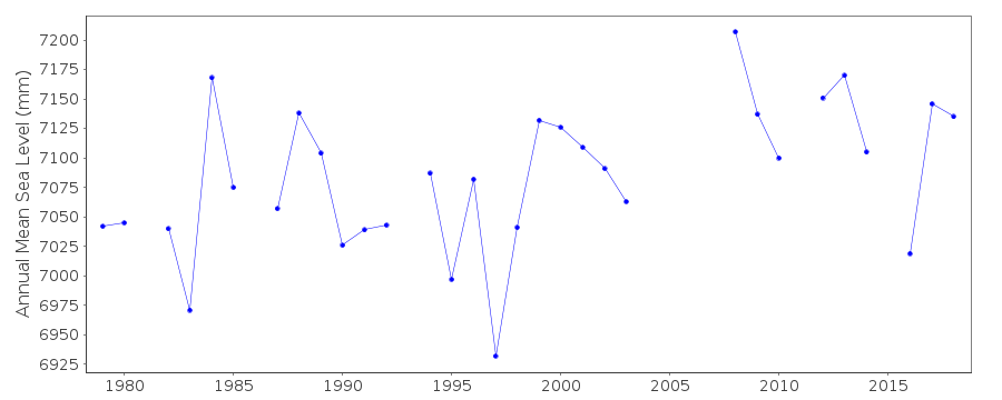 PSMSL Monthly Mean Sea Level for '1474' 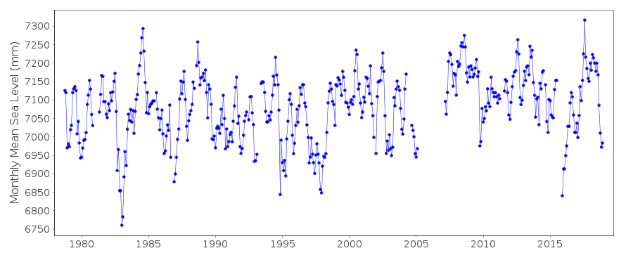
|
|
|