| Station catalog metadata [edit] | [station overview] |
|---|
| SSC ID | SSC-sainw |
| Station Name | Saint Pierre et Miquelon |
| Country | Saint Pierre and Miquelon |
| Latitude | 46.778833 |
| Longitude | -56.168306 |
| DateLastModified | 2022-09-13 21:25:33 |
| Linked codes |
|---|
| Codes | Location | Latitude | Longitude | Sensors |
IOC: spmi | Saint Pierre et Miquelon, Canada | 46.778833 | -56.168305 | rad |
PSMSL: 2246 | SAINT PIERRE ET MIQUELON | 46.778833 | -56.168306 | N/A |
SONEL_GPS: 3408 | SAINT-PIERRE-ET-MIQUELON | 46.77782379 | -56.16824438 | N/A |
SONEL_TG: 3166 | SAINT-PIERRE-ET-MIQUELON | 46.77883333 | -56.16830556 | N/A |
| Distributed metadata source: IOC Sea Level Station Monitoring Facility spmi |
|---|
| Status | Operational |
| Local Contact | Service hydrographique et océanographique de la marine ( France ) |
| Connection | FTP box |
| Country | France |
| Sensor 1 | |
| Type of sensor | rad |
| Sampling rate (min) | 1 |
| Distributed metadata source: PSMSL |
| Name | SAINT PIERRE ET MIQUELON |
| SONEL id | 3408 |
| Is RLR | Y |
| Has RLR Diagram | Y link |
| QC Flag | N |
| Old ID | 970/115 |
| Last Updated | 2026-02-20 |
| Supplier | SERVICE HYD. ET OCEAN. DE LA MARINE |
| Address | SHOM, 13 rue de Chatelier, 29200 BREST , FRANCE |
| Metric Start | 2012 |
| Metric End | 2025 |
| Metric Completeness | 85.1 |
| RLR Start | 2012 |
| RLR End | 2025 |
| RLR Completeness | 85.1 |
| Download metric sea level data. | Use only with extreme caution. |
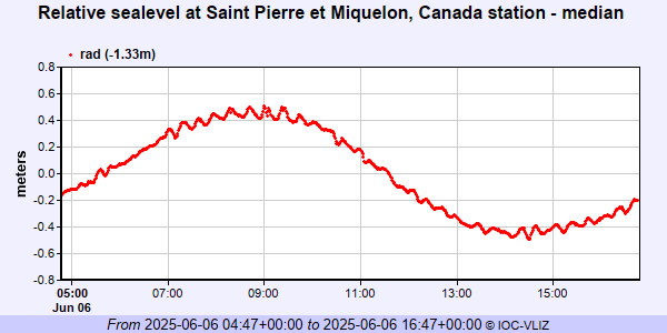
IOC Sea Level Station Monitoring Facility - realtime graph for 'spmi'
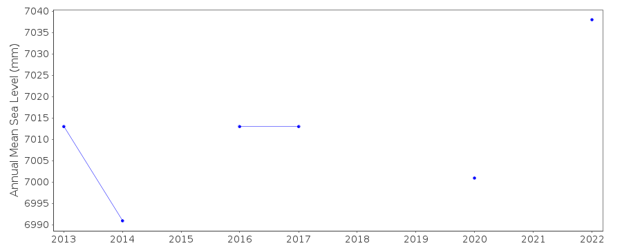
PSMSL Annual Mean Sea Level for '2246'
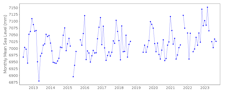
PSMSL Monthly Mean Sea Level for '2246'