 |
SEALEVEL STATION CATALOG (SSC) |
|
|
|
|
|
| Station catalog metadata [edit] | [station overview] |
|---|
| SSC ID | SSC-riki | | Station Name | Rikitea | | Country | France | | Latitude | -23.122189 | | Longitude | -134.966628 | | DateLastModified | 2025-05-08 22:03:49 |
| Linked codes |
|---|
| Codes | Location | Latitude | Longitude | Sensors | IOC: gamb | Rikitea (French Polynesia, Gambier, Mangareva) | -23.117774 | -134.968888 | prs, rad, bat |
IOC: riki | Rikitea (Gambier, French Polynesia) | -23.122189 | -134.966628 | prs, rad, enc, bat, sw1, sw2 |
GLOSS: 138 | Rikitea, Gambier | -23.13333 | -134.95 | Float |
UHSLC: 16 | Rikitea | -23.125 | -134.953 | N/A |
PTWC: gamb | Rikitea_PF | -23.1178 | -134.9689 | prs, rad |
PTWC: riki | Rikitea_PF | -23.1221 | -134.9666 | prs, rad, enc |
PSMSL: 1253 | RIKITEA | -23.122268 | -134.966749 | N/A |
PSMSL: 2370 | RIKITEA, GAMBIER | -23.1178 | -134.969 | N/A |
SONEL_GPS: 2015 | RIKITEA, GAMBIER | -23.13035835 | -134.96481560 | N/A |
SONEL_GPS: 3418 | RIKITEA, GAMBIER | -23.11780000 | -134.96900000 | N/A |
SONEL_TG: 1985 | RIKITEA, GAMBIER | -23.12228270 | -134.96660070 | N/A |
SONEL_TG: 3410 | RIKITEA, GAMBIER | -23.11780000 | -134.96900000 | N/A |
| Distributed metadata source: IOC Sea Level Station Monitoring Facility gamb |
|---|
| GTS station code | FAA0542E |
| GTS message type | SEHI40 |
| Status | Operational |
| Local Contact | Service hydrographique et océanographique de la marine ( France ) |
| Connection | GTS message |
| Country | France |
| Sensor 1 | |
| Type of sensor | prs |
| Sampling rate (min) | 1 |
| Sensor 2 | |
| Type of sensor | rad |
| Sampling rate (min) | 1 |
| Sensor 3 | |
| Type of sensor | bat |
| Sampling rate (min) | 5 |
| Distributed metadata source: IOC Sea Level Station Monitoring Facility riki |
|---|
| GTS station code | 3541F0D6 |
| GTS message type | SEPO40 |
| Status | Down |
| Local Contact | Commissariat à l'Energie Atomique ( France ) |
| Other Contact | University of Hawaii Sea Level Center ( USA ) |
| Connection | GTS message |
| Country | France |
| Sensor 1 | |
| Type of sensor | prs |
| Sampling rate (min) | 1 |
| Sensor 2 | |
| Type of sensor | rad |
| Sampling rate (min) | 1 |
| Sensor 3 | |
| Type of sensor | enc |
| Sampling rate (min) | 5 |
| Sensor 4 | |
| Type of sensor | sw1 |
| Sampling rate (min) | 60 |
| Sensor 5 | |
| Type of sensor | sw2 |
| Sampling rate (min) | 60 |
| Sensor 6 | |
| Type of sensor | bat |
| Sampling rate (min) | 5 |
| Distributed metadata source: GLOSS Station Handbook |
|---|
| Time Zone | 135W, GMT - 9hrs | | Ocean | Pacific | | Operational | Yes | | Data acquisition rate | 15 minute interval | | Tide gauge benchmarks | USGS BM #1: Brass plate stamped 'no 1 1969' located 20ft west of the tide station set in concrete on wharf surface (established 1969) | | Auxiliary benchmarks | USGS BM #2: Brass plate stamped 'no 2 1969' set in cement sidewalk at NE corner of bunkhouse close to the catchment tanks
USGS BM #3: Brass plate stamped 'no 3 1969' set in concrete at side of arch on roadway leading to LDG laboratory, 1.5ft up the side
IO: Brass plate, no further documentation, established Apr 1984
C: Brass plate, no further documentation, established Apr 1984
| | Other relevant information | Daily values calculated using 119-point convolution filter (Bloomfield, 1976) centred on noon applied to the hourly data with respective periods of the 95, 50 and 5% amplitude points at 124.0, 60.2 and 40.2 hours. | | Other relevant codes | UHSLC 016 |
| Distributed metadata source: PTWC COMP META file |
| DCP ID | FAA0542E |
| WMO | SEHI40 |
| Samp Rate | 1 |
| Num# Samp | 5 |
| Unit | M |
| Scale | 1.0000 |
| Xmt Int. | 005 |
| Fst Min. | 0003 |
| HAR | 1 |
| Owner | SHOM |
| Distributed metadata source: UHSLC |
| UHSLC id | 016 |
| SSC id | riki |
| GLOSS id | 138 |
| UHSLC geojson | https://uhslc.soest.hawaii.edu/data/meta.geojson |
| Research quality data version a | 1969-10-06 - 2018-12-31 |
| RQ basin | pacific |
| Fast delivery | 1969-10-06 - 2026-04-30 |
| Distributed metadata source: PSMSL |
| Name | RIKITEA |
| GLOSS id | 138 |
| UHSLC ID | 16 |
| SONEL id | 3418 |
| Is RLR | Y |
| Has RLR Diagram | Y link |
| QC Flag | N |
| Old ID | 808/001 |
| Last Updated | 2020-01-28 |
| Supplier | UNIVERSITY OF HAWAII SEA LEVEL CENTER |
| Address | University of Hawaii Sea Level Center, Department of Oceanography Division of Natural Sciences, 1000 Pope Road, Honolulu, Hawaii 96822, UNITED STATES |
| Metric Start | 1969 |
| Metric End | 2018 |
| Metric Completeness | 93.7 |
| RLR Start | 1969 |
| RLR End | 2018 |
| RLR Completeness | 93.7 |
| Download metric sea level data. | Use only with extreme caution. |
| Name | RIKITEA, GAMBIER |
| UHSLC ID | 16 |
| Is RLR | N |
| Has RLR Diagram | N link |
| QC Flag | N |
| Last Updated | 2026-02-20 |
| Supplier | SERVICE HYD. ET OCEAN. DE LA MARINE |
| Address | SHOM, 13 rue de Chatelier, 29200 BREST , FRANCE |
| Metric Start | 1965 |
| Metric End | 2024 |
| Metric Completeness | 61.1 |
| Download metric sea level data. | Use only with extreme caution. |
IOC Sea Level Station Monitoring Facility - realtime graph for 'gamb' 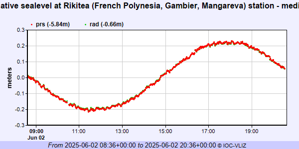 IOC Sea Level Station Monitoring Facility - realtime graph for 'riki'  PSMSL Annual Mean Sea Level for '1253' 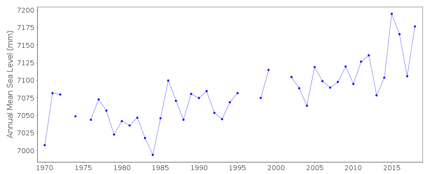 PSMSL Annual Mean Sea Level for '2370'  PSMSL Monthly Mean Sea Level for '2370' 
|
|
|