| Station catalog metadata [edit] | [station overview] |
|---|
| SSC ID | SSC-reun |
| Station Name | Pointe des Galets |
| Country | France |
| Latitude | -20.92 |
| Longitude | 55.28 |
| DateLastModified | 2025-05-08 22:03:48 |
| Linked codes |
|---|
| Codes | Location | Latitude | Longitude | Sensors |
IOC: reun | Pointe des Galets (Reunion Island) | -20.92 | 55.28 | rad |
IOC: reun2 | Pointe des Galets (Reunion Island) 2 | -20.92 | 55.28 | rad |
GLOSS: 17 | Pte des Galets, Reunion Is | -20.93333 | 55.3 | Float |
UHSLC: 164 | Reunion | -20.923 | 55.293 | N/A |
PTWC: reun | Reunion_FR | -20.9350 | 55.2847 | rad |
PSMSL: 1501 | POINTE DES GALETS | -20.934924 | 55.285005 | N/A |
SONEL_TG: 1827 | POINTE DES GALETS | -20.93492400 | 55.28500500 | N/A |
| Distributed metadata source: IOC Sea Level Station Monitoring Facility reun |
|---|
| Status | Operational |
| Local Contact | Service hydrographique et océanographique de la marine ( France ) |
| Other Contact | Service hydrographique et océanographique de la marine ( France ) |
| Connection | FTP box |
| Country | France |
| Sensor 1 | |
| Type of sensor | rad |
| Sampling rate (min) | 1 |
| Distributed metadata source: IOC Sea Level Station Monitoring Facility reun2 |
|---|
| GTS station code | FR110 |
| GTS message type | SZIO02 |
| Status | Operational |
| Local Contact | Service hydrographique et océanographique de la marine ( France ) |
| Other Contact | Service hydrographique et océanographique de la marine ( France ) |
| Connection | GTS message |
| Country | France |
| Sensor 1 | |
| Type of sensor | rad |
| Sampling rate (min) | 1 |
| Distributed metadata source: GLOSS Station Handbook |
|---|
| Time Zone | 060E, GMT + 4hrs |
| Ocean | Indian |
| Operational | Yes |
| Responsible country | France |
| Other relevant codes | UHSLC 164 |
| Distributed metadata source: PTWC COMP META file |
| DCP ID | 162134C6 |
| WMO | FTPI00 |
| Samp Rate | 1 |
| Num# Samp | 15 |
| Unit | M |
| Scale | 1.0000 |
| Xmt Int. | 015 |
| Fst Min. | 0001 |
| HAR | 1 |
| Owner | SHOM |
| Distributed metadata source: UHSLC |
| UHSLC id | 164 |
| SSC id | reun |
| GLOSS id | 17 |
| UHSLC geojson | https://uhslc.soest.hawaii.edu/data/meta.geojson |
| Research quality data version a | 1967-03-01 - 2018-12-31 |
| RQ basin | indian |
| Fast delivery | 1967-03-01 - 2026-04-30 |
| Distributed metadata source: PSMSL |
| Name | POINTE DES GALETS |
| GLOSS id | 17 |
| UHSLC ID | 164 |
| SONEL id | 4179 |
| Is RLR | Y |
| Has RLR Diagram | Y link |
| QC Flag | N |
| Old ID | 451/001 |
| Last Updated | 2026-02-20 |
| Supplier | SERVICE HYD. ET OCEAN. DE LA MARINE |
| Address | SHOM, 13 rue de Chatelier, 29200 BREST , FRANCE |
| Metric Start | 1967 |
| Metric End | 2025 |
| Metric Completeness | 61.7 |
| RLR Start | 1967 |
| RLR End | 2025 |
| RLR Completeness | 58.9 |
| Download metric sea level data. | Use only with extreme caution. |
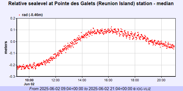
IOC Sea Level Station Monitoring Facility - realtime graph for 'reun'
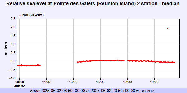
IOC Sea Level Station Monitoring Facility - realtime graph for 'reun2'
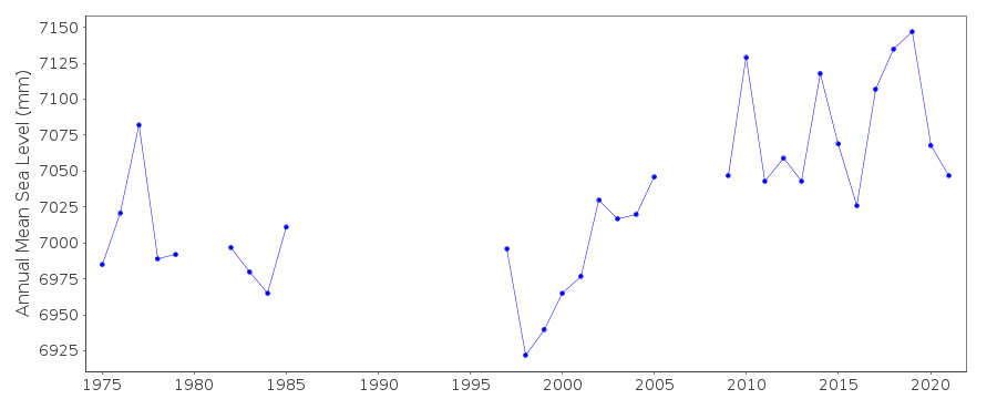
PSMSL Annual Mean Sea Level for '1501'
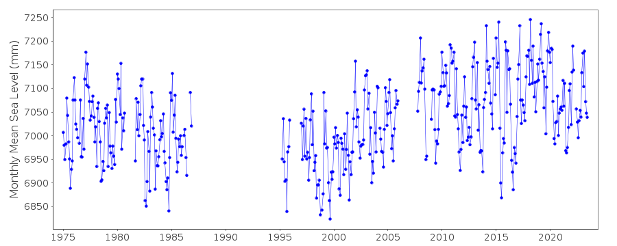
PSMSL Monthly Mean Sea Level for '1501'