 |
SEALEVEL STATION CATALOG (SSC) |
|
|
|
|
|
| Station catalog metadata [edit] | [station overview] |
|---|
| SSC ID | SSC-raro | | Station Name | Rarotonga | | Country | Cook Islands | | Latitude | -21.2 | | Longitude | -159.783 | | DateLastModified | 2015-10-22 19:02:29 |
| Distributed metadata source: IOC Sea Level Station Monitoring Facility raro |
|---|
| GTS station code | 65980 |
| GTS message type | SZPS01 |
| Status | Operational |
| Local Contact | National Tidal Centre/Australian Bureau of Meteorology ( Australia ) |
| Connection | GTS message |
| Country | Cook Islands |
| Sensor 1 | |
| Type of sensor | aqu |
| Sampling rate (min) | 1 |
| Distributed metadata source: IOC Sea Level Station Monitoring Facility raro2 |
|---|
| GTS station code | 65981 |
| GTS message type | SZPS01 |
| Status | Down |
| Local Contact | National Tidal Centre/Australian Bureau of Meteorology ( Australia ) |
| Connection | GTS message |
| Country | Cook Islands |
| Sensor 1 | |
| Type of sensor | rad |
| Sampling rate (min) | 1 |
| Distributed metadata source: GLOSS Station Handbook |
|---|
| Time Zone | 150W, GMT - 10hrs | | Ocean | Pacific | | Operational | Yes | | Responsible country | Australia | | Data acquisition rate | 6 minute intervals | | Additional parameters | Barometric pressure, water and air temperature, wind speed and direction. | | Tide gauge benchmarks | CT/1: triangular stamp (steel pin) with '1' at centre of concrete emplacement; located across street from tide house in parking area of courtyard of govt house near flagpole. Fixed within island wide survey. | | Auxiliary benchmarks | UH-1: SS pin in concrete emplaced about 10ft W of tide staff at edge of quay, about 2ft from water on cement slab, which seems to be sinking.
UH-2: 1 inch SS disc, no stamp, emplaced in concrete about 10ft E of tide staff on finger pier. Not locatable in Feb. 1992 - destroyed.
UH-4: 1 inch square SS on top of pin set in white epoxy in cement, located near the closest corner of bldg to right, facing away from sea.
| | Other relevant information | Backup gauges on site: 1) Leupold Stevens ADR (December 1984-)
2) Handar encoder ADR (December 1984-)
Daily values calculated using 119-point convolution filter (Bloomfield, 1976) centred on noon applied to the hourly data with respective periods of the 95, 50 and 5% amplitude points at 124.0, 60.2 and 40.2 hours.
| | Other relevant codes | NTF port no. 65980, UHSLC 023 |
| Distributed metadata source: PTWC COMP META file |
| DCP ID | |
| WMO | |
| Samp Rate | |
| Num# Samp | |
| Unit | |
| Scale | |
| Xmt Int. | |
| Fst Min. | |
| HAR | |
| Owner | |
| Distributed metadata source: UHSLC |
| UHSLC id | 023 |
| SSC id | raro |
| GLOSS id | 139 |
| UHSLC geojson | https://uhslc.soest.hawaii.edu/data/meta.geojson |
| Research quality data version a | 1977-04-25 - 1997-12-08 |
| Research quality data version b | 1993-02-20 - 2021-12-31 |
| RQ basin | pacific |
| Fast delivery | 1993-02-20 - 2026-04-30 |
| Distributed metadata source: PSMSL |
| Name | RAROTONGA |
| GLOSS id | 139 |
| UHSLC ID | 23 |
| SONEL id | 655 |
| Is RLR | N |
| Has RLR Diagram | N link |
| QC Flag | N |
| Old ID | 785/001 |
| Last Updated | 2015-11-04 |
| Supplier | UNIVERSITY OF HAWAII SEA LEVEL CENTER |
| Address | University of Hawaii Sea Level Center, Department of Oceanography Division of Natural Sciences, 1000 Pope Road, Honolulu, Hawaii 96822, UNITED STATES |
| Metric Start | 1977 |
| Metric End | 2014 |
| Metric Completeness | 95.8 |
| Download metric sea level data. | Use only with extreme caution. |
| Name | RAROTONGA B |
| GLOSS id | 139 |
| UHSLC ID | 23 |
| SONEL id | 655 |
| Is RLR | Y |
| Has RLR Diagram | Y link |
| QC Flag | N |
| Old ID | 785/006 |
| Last Updated | 2026-06-01 |
| Supplier | NATIONAL TIDAL CENTRE |
| Address | National Tidal Centre, Bureau of Meteorology, PO Box 421, Kent Town 5071, South Australia, AUSTRALIA |
| Metric Start | 1993 |
| Metric End | 2026 |
| Metric Completeness | 95.6 |
| RLR Start | 1993 |
| RLR End | 2026 |
| RLR Completeness | 95.6 |
| Download metric sea level data. | Use only with extreme caution. |
IOC Sea Level Station Monitoring Facility - realtime graph for 'raro' 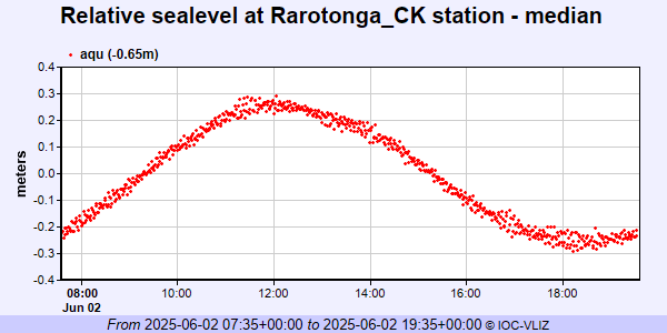 IOC Sea Level Station Monitoring Facility - realtime graph for 'raro2'  PSMSL Annual Mean Sea Level for '1453'  PSMSL Annual Mean Sea Level for '1843' 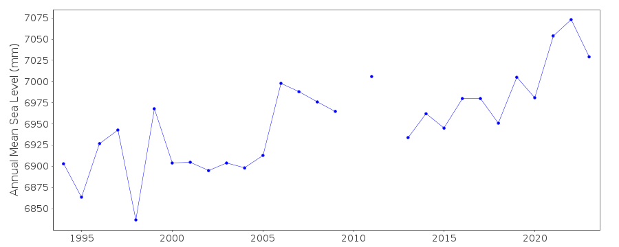 PSMSL Monthly Mean Sea Level for '1843' 
|
|
|