 |
SEALEVEL STATION CATALOG (SSC) |
|
|
|
|
|
| Station catalog metadata [edit] | [station overview] |
|---|
| SSC ID | SSC-quin | | Station Name | Qui Nhon | | Country | Vietnam | | Latitude | 13.7751 | | Longitude | 109.2543 | | DateLastModified | 2021-09-24 10:56:57 |
| Linked codes |
|---|
| Codes | Location | Latitude | Longitude | Sensors | IOC: quin | Qui_Nhon | 13.7751 | 109.2543 | prs, rad, ra2, ras, enc, bat, sw2 |
GLOSS: 75 | Qui Nhon | 13.76666 | 109.21666 | Float |
UHSLC: 381 | Qui Nhon | 13.767 | 109.25 | N/A |
PTWC: quin | Qui_Nhon_VN | 13.7751 | 109.2543 | enc, prs, ra2, rad, ras |
PSMSL: 1449 | QUINHON | 13.766667 | 109.25 | N/A |
PSMSL: 2267 | QUI NHON II | 13.775 | 109.255 | N/A |
SONEL_TG: 2826 | QUINHON | 13.77102100 | 109.25084700 | N/A |
| Distributed metadata source: IOC Sea Level Station Monitoring Facility quin |
|---|
| GTS station code | 300434064206280 |
| GTS message type | SZXX01 |
| Status | Operational |
| Local Contact | Hydro-meteorological and Environmental Station Network Center ( Vietnam ) |
| Other Contact | University of Hawaii Sea Level Center ( USA ) |
| Connection | GTS message |
| Country | Viet Nam |
| Sensor 1 | |
| Type of sensor | prs |
| Sampling rate (min) | 1 |
| Sensor 2 | |
| Type of sensor | rad |
| Sampling rate (min) | 1 |
| Sensor 3 | |
| Type of sensor | ra2 |
| Sampling rate (min) | 1 |
| Sensor 4 | |
| Type of sensor | ras |
| Sampling rate (min) | 1 |
| Sensor 5 | |
| Type of sensor | enc |
| Sampling rate (min) | 1 |
| Sensor 6 | |
| Type of sensor | bat |
| Sampling rate (min) | 5 |
| Sensor 7 | |
| Type of sensor | sw2 |
| Sampling rate (min) | 60 |
| Distributed metadata source: GLOSS Station Handbook |
|---|
| Time Zone | 105E, GMT + 7hrs | | Ocean | Pacific | | Operational | Yes | | Responsible country | Viet Nam | | Data acquisition rate | Continuous recording | | Additional parameters | Sea temperature | | Tide gauge benchmarks | Marine Hydrometeorological Office at Qui Nhon bolt outside of tide gauge shelter, adjacent to front wall of shelter, grid reference MC (from March 1987). | | Benchmark relationships | Tide Gauge Zero (TGZ) = Admiralty Chart Datum.
TGZ = 3.546m below TGBM | | Auxiliary benchmarks | 8.00m NW of tide gauge, grid reference MT. | | Other relevant information | Primary data from period 1959 to 1963 recorded by float gauge/stilling well was lost because of the war, and the tide gauge was completely ruined. | | Nearest Met. station | Quinhon station 3km from gauge |
| Distributed metadata source: PTWC COMP META file |
| DCP ID | 300434064206280 |
| WMO | SZXX01 |
| Samp Rate | 1 |
| Num# Samp | 5 |
| Unit | M |
| Scale | 1.0000 |
| Xmt Int. | 005 |
| Fst Min. | 0001 |
| HAR | 1 |
| Owner | UHSLC |
| Distributed metadata source: UHSLC |
| UHSLC id | 381 |
| SSC id | quin |
| GLOSS id | 75 |
| UHSLC geojson | https://uhslc.soest.hawaii.edu/data/meta.geojson |
| Research quality data version a | 1994-01-01 - 2005-12-30 |
| Research quality data version b | 2007-10-20 - 2018-12-30 |
| RQ basin | pacific |
| Fast delivery | 2007-10-20 - 2026-04-30 |
| Distributed metadata source: PSMSL |
| Name | QUINHON |
| GLOSS id | 75 |
| UHSLC ID | 381 |
| Is RLR | Y |
| Has RLR Diagram | Y link |
| QC Flag | N |
| Old ID | 605/041 |
| Last Updated | 2015-11-17 |
| Supplier | MARINE HYDROMETEOROLOGICAL CENTRE |
| Address | Marine Hydrometeorological Centre, Hydro-meteorological and Environmental , Station Network Center, No. 62 Nguyen Chi Thanh Street, Dong Da, Hanoi, VIET NAM |
| Metric Start | 1977 |
| Metric End | 2013 |
| Metric Completeness | 99.1 |
| RLR Start | 1977 |
| RLR End | 2013 |
| RLR Completeness | 99.1 |
| Download metric sea level data. | Use only with extreme caution. |
| Name | QUI NHON II |
| GLOSS id | 75 |
| UHSLC ID | 381 |
| Is RLR | Y |
| Has RLR Diagram | Y link |
| QC Flag | N |
| Old ID | 605/042 |
| Last Updated | 2020-01-29 |
| Supplier | UNIVERSITY OF HAWAII SEA LEVEL CENTER |
| Address | University of Hawaii Sea Level Center, Department of Oceanography Division of Natural Sciences, 1000 Pope Road, Honolulu, Hawaii 96822, UNITED STATES |
| Metric Start | 2007 |
| Metric End | 2018 |
| Metric Completeness | 82.6 |
| RLR Start | 2007 |
| RLR End | 2018 |
| RLR Completeness | 82.6 |
| Download metric sea level data. | Use only with extreme caution. |
IOC Sea Level Station Monitoring Facility - realtime graph for 'quin' 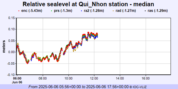 PSMSL Annual Mean Sea Level for '1449'  PSMSL Annual Mean Sea Level for '2267' 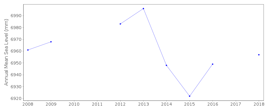 PSMSL Monthly Mean Sea Level for '2267' 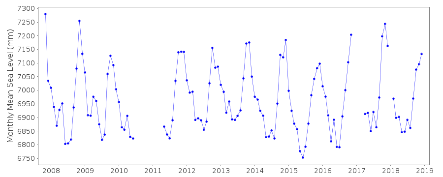
|
|
|