 |
SEALEVEL STATION CATALOG (SSC) |
|
|
|
|
|
| Station catalog metadata [edit] | [station overview] |
|---|
| SSC ID | SSC-puern | | Station Name | Puerto Bolivar | | Country | Ecuador | | Latitude | -3.266667 | | Longitude | -80 | | DateLastModified | 2015-10-22 19:02:29 |
| Linked codes |
|---|
| Codes | Location | Latitude | Longitude | Sensors | IOC: pbol | Puerto Bolívar | -3.25927 | -80.00194 | rad |
PTWC: pbol | Puerto_Bolivar_EC | -3.2593 | -80.0019 | rad |
PSMSL: 1277 | PUERTO BOLIVAR | -3.266667 | -80.0 | N/A |
SONEL_GPS: 2083 | PUERTO BOLIVAR | -3.26080000 | -79.95731400 | N/A |
SONEL_TG: 2446 | PUERTO BOLIVAR | -3.26000000 | -80.00000000 | N/A |
| Distributed metadata source: IOC Sea Level Station Monitoring Facility pbol |
|---|
| Status | Operational |
| Local Contact | Instituto Oceanográfico de la Armada ( Ecuador ) |
| Connection | WEB service |
| Country | Ecuador |
| Sensor 1 | |
| Type of sensor | rad |
| Sampling rate (min) | 1 |
| Distributed metadata source: PTWC COMP META file |
| DCP ID | 1234ABC5 |
| WMO | FTPI00 |
| Samp Rate | 1 |
| Num# Samp | 10 |
| Unit | m |
| Scale | 1.0000 |
| Xmt Int. | 010 |
| Fst Min. | 0000 |
| HAR | 0 |
| Owner | IOA |
| Distributed metadata source: PSMSL |
| Name | PUERTO BOLIVAR |
| Is RLR | Y |
| Has RLR Diagram | Y link |
| QC Flag | N |
| Old ID | 845/041 |
| Last Updated | 1992-06-16 |
| Supplier | OCEANOGRAPHIC INSTITUTE OF THE NAVY (INOCAR) |
| Address | Oceanographic Institute of the Navy, Av. July 25 Via Puerto Maritime, Naval Base South, Guayaquil, ECUADOR |
| Metric Start | 1970 |
| Metric End | 1991 |
| Metric Completeness | 74.6 |
| RLR Start | 1970 |
| RLR End | 1991 |
| RLR Completeness | 74.6 |
| Download metric sea level data. | Use only with extreme caution. |
IOC Sea Level Station Monitoring Facility - realtime graph for 'pbol' 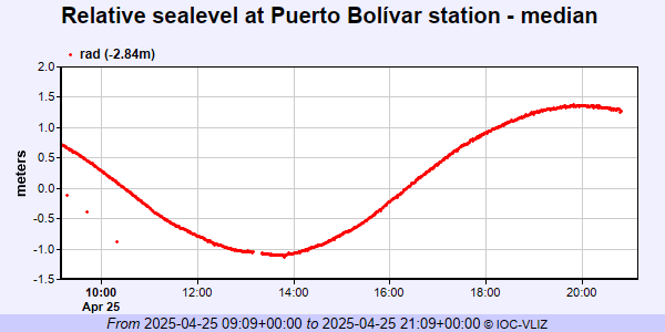 PSMSL Annual Mean Sea Level for '1277' 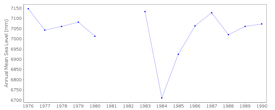 PSMSL Monthly Mean Sea Level for '1277' 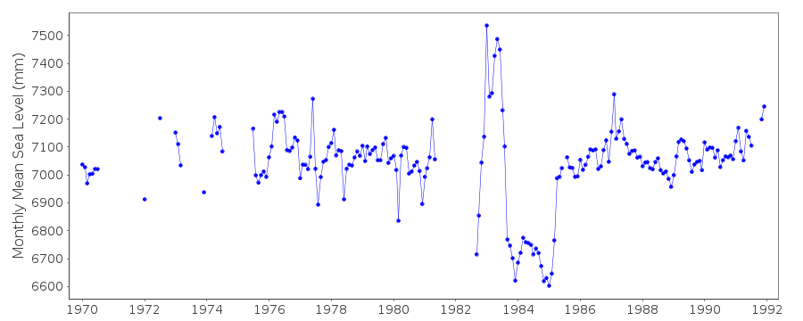
|
|
|