 |
SEALEVEL STATION CATALOG (SSC) |
|
|
|
|
|
| Station catalog metadata [edit] | [station overview] |
|---|
| SSC ID | SSC-puer | | Station Name | Puerto De Hierro | | Country | Venezuela | | Latitude | 10.616667 | | Longitude | -62.083333 | | DateLastModified | 2015-10-22 19:02:29 |
| Linked codes |
|---|
| Codes | Location | Latitude | Longitude | Sensors | PSMSL: 782 | PUERTO DE HIERRO | 10.616667 | -62.083333 | N/A |
| Distributed metadata source: PSMSL |
| Name | PUERTO DE HIERRO |
| Is RLR | Y |
| Has RLR Diagram | Y link |
| QC Flag | N |
| Old ID | 900/001 |
| Last Updated | null |
| Supplier | MINISTERIO DE OBRAS PUBLICAS, VENEZUELA |
| Address | Ministerio de Obras Publicas, Direccion de Cartografia Nacional, Caracas, VENEZUELA, BOLIVARIAN REPUBLIC OF |
| Metric Start | 1955 |
| Metric End | 1963 |
| Metric Completeness | 93.5 |
| RLR Start | 1955 |
| RLR End | 1963 |
| RLR Completeness | 93.5 |
| Download metric sea level data. | Use only with extreme caution. |
PSMSL Annual Mean Sea Level for '782' 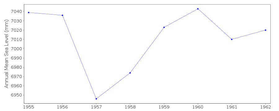 PSMSL Monthly Mean Sea Level for '782' 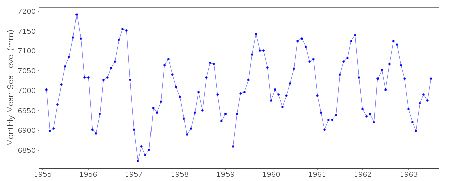
|
|
|