 |
SEALEVEL STATION CATALOG (SSC) |
|
|
|
|
|
| Station catalog metadata [edit] | [station overview] |
|---|
| SSC ID | SSC-pual | | Station Name | Puerto Aldea | | Country | Chile | | Latitude | -30.292161 | | Longitude | -71.6079 | | DateLastModified | 2022-01-20 00:44:39 |
| Linked codes |
|---|
| Codes | Location | Latitude | Longitude | Sensors | IOC: ptal | Puerto Aldea_CL | -30.2923 | -71.607564 | prs, rad |
IOC: ptal2 | Puerto Aldea_CL | -30.2923 | -71.607564 | prs, rad |
PSMSL: 2458 | PUERTO ALDEA | -30.292222222222225 | -71.60749999999999 | N/A |
| Distributed metadata source: IOC Sea Level Station Monitoring Facility ptal |
|---|
| GTS station code | ADC0802A |
| GTS message type | SXCH40 |
| Status | Operational |
| Local Contact | Servicio Hidrográfico y Oceanográfico de la Armada ( Chile ) |
| Other Contact | Servicio Hidrográfico y Oceanográfico de la Armada ( Chile ) |
| Connection | GTS message |
| Country | Chile |
| Sensor 1 | |
| Type of sensor | prs |
| Sampling rate (min) | 1 |
| Sensor 2 | |
| Type of sensor | rad |
| Sampling rate (min) | 1 |
| Distributed metadata source: IOC Sea Level Station Monitoring Facility ptal2 |
|---|
| Status | Operational |
| Local Contact | Servicio Hidrográfico y Oceanográfico de la Armada ( Chile ) |
| Other Contact | Servicio Hidrográfico y Oceanográfico de la Armada ( Chile ) |
| Connection | WEB service |
| Country | Chile |
| Sensor 1 | |
| Type of sensor | prs |
| Sampling rate (min) | 1 |
| Sensor 2 | |
| Type of sensor | rad |
| Sampling rate (min) | 1 |
| Distributed metadata source: PSMSL |
| Name | PUERTO ALDEA |
| Is RLR | N |
| Has RLR Diagram | N link |
| QC Flag | N |
| Last Updated | 2025-06-12 |
| Supplier | HYDROGRAPHIC AND OCEANOGRAPHIC SERVICE OF THE CHILEAN NAVY |
| Address | Hydrographic and Oceanographic Service of the Chilean Navy, Errazuriz 254, Playa Ancha , Valparaiso, CHILE |
| Metric Start | 2018 |
| Metric End | 2024 |
| Metric Completeness | 86.9 |
| Download metric sea level data. | Use only with extreme caution. |
IOC Sea Level Station Monitoring Facility - realtime graph for 'ptal' 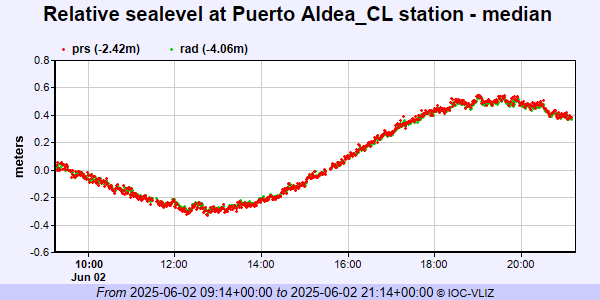 IOC Sea Level Station Monitoring Facility - realtime graph for 'ptal2' 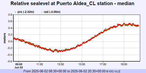 PSMSL Annual Mean Sea Level for '2458'  PSMSL Monthly Mean Sea Level for '2458' 
|
|
|