 |
SEALEVEL STATION CATALOG (SSC) |
|
|
|
|
|
| Station catalog metadata [edit] | [station overview] |
|---|
| SSC ID | SSC-ptsp | | Station Name | Port of Spain | | Country | Trinidad and Tobago | | Latitude | 10.65 | | Longitude | -61.51666 | | DateLastModified | 2015-10-22 19:02:29 |
| Linked codes |
|---|
| Codes | Location | Latitude | Longitude | Sensors | IOC: ptsp | Port of Spain | 10.65 | -61.51666 | rad |
GLOSS: 203 | Port of Spain | 10.65 | -61.51666 | Float, Bubbler |
UHSLC: 248 | Portf-Spain | 10.65 | -61.517 | N/A |
PTWC: ptsp | Port_of_Spain_TT | 10.6500 | -61.5167 | rad |
PSMSL: 415 | PORT OF SPAIN | 10.65 | -61.516667 | N/A |
SONEL_GPS: 3512 | PORT OF SPAIN | 10.63950000 | -61.39900000 | N/A |
SONEL_TG: 2870 | PORT OF SPAIN | 10.65000000 | -61.51666000 | N/A |
| Distributed metadata source: IOC Sea Level Station Monitoring Facility ptsp |
|---|
| GTS station code | A9C000B6 |
| GTS message type | SOTD10 |
| Status | Operational |
| Local Contact | Land and Surveys Division, Hydrographic Unit ( Trinidad and Tobago ) |
| Other Contact | Caribbean Community Climate Change Centre ( Trinidad and Tobago ) |
| Other Contact | International Tsunami Information Center Caribbean Office ( USA ) |
| Connection | GTS message |
| Country | Trinidad & Tobago |
| Sensor 1 | |
| Type of sensor | rad |
| Sampling rate (min) | 10 |
| Distributed metadata source: GLOSS Station Handbook |
|---|
| Time Zone | 060W, GMT - 4hrs | | Ocean | Atlantic | | Operational | Yes | | Responsible country | Trinidad and Tobago | | Data acquisition rate | Hourly | | Other relevant information | Port of Spain datum was determined by precise levelling from a reference benchmark in Port of Spain. All of the original admiralty benchmarks around the site have been destroyed, although some have been re-established. . It is located on the northwest side of the Fire Pump House in the Port facility. Visits to download data are irregular. | | Other relevant codes | UHSLC 248 |
| Distributed metadata source: PTWC COMP META file |
| DCP ID | A9C000B6 |
| WMO | SOTD10 |
| Samp Rate | 10 |
| Num# Samp | 6 |
| Unit | M |
| Scale | -1.0000 |
| Xmt Int. | 060 |
| Fst Min. | 0018 |
| HAR | 1 |
| Owner | CPACC |
| Distributed metadata source: UHSLC |
| UHSLC id | 248 |
| SSC id | ptsp |
| GLOSS id | 203 |
| UHSLC geojson | https://uhslc.soest.hawaii.edu/data/meta.geojson |
| Research quality data version a | 1984-01-02 - 1992-12-06 |
| RQ basin | atlantic |
| Distributed metadata source: PSMSL |
| Name | PORT OF SPAIN |
| GLOSS id | 203 |
| UHSLC ID | 248 |
| SONEL id | 3512 |
| Is RLR | Y |
| Has RLR Diagram | Y link |
| QC Flag | N |
| Old ID | 890/001 |
| Last Updated | 1999-11-15 |
| Supplier | HYDROGRAPHIC UNIT, PORT OF SPAIN |
| Address | Hydrographic Unit, P.O. Box 1104, Port of Spain, TRINIDAD AND TOBAGO |
| Metric Start | 1937 |
| Metric End | 1992 |
| Metric Completeness | 22.3 |
| RLR Start | 1983 |
| RLR End | 1992 |
| RLR Completeness | 83.3 |
| Download metric sea level data. | Use only with extreme caution. |
IOC Sea Level Station Monitoring Facility - realtime graph for 'ptsp' 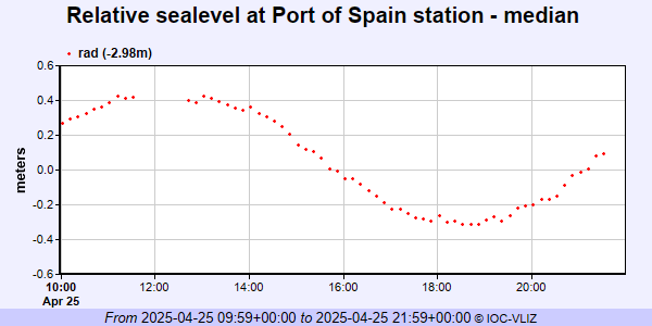 PSMSL Annual Mean Sea Level for '415' 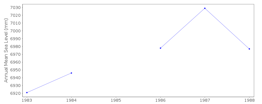 PSMSL Monthly Mean Sea Level for '415' 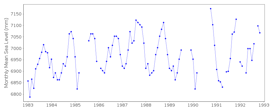
|
|
|