 |
SEALEVEL STATION CATALOG (SSC) |
|
|
|
|
|
| Station catalog metadata [edit] | [station overview] |
|---|
| SSC ID | SSC-pthe | | Station Name | Port Hedland | | Country | Australia | | Latitude | -20.31666 | | Longitude | 118.56666 | | DateLastModified | 2015-10-22 19:02:29 |
| Distributed metadata source: IOC Sea Level Station Monitoring Facility phcp |
|---|
| GTS station code | 62585 |
| GTS message type | SZAU01 |
| Status | Down |
| Local Contact | National Tidal Centre/Australian Bureau of Meteorology ( Australia ) |
| Connection | GTS message |
| Country | Australia |
| Sensor 1 | |
| Type of sensor | rad |
| Sampling rate (min) | 1 |
| Distributed metadata source: GLOSS Station Handbook |
|---|
| Time Zone | 120E, GMT + 8hrs | | Ocean | Indian | | Operational | Yes | | Responsible country | Australia | | Data acquisition rate | 5 minute samples | | Additional parameters | None | | Tide gauge benchmarks | DMH 101: A brass plaque set into concrete deck of No. 3 Berth beneath the salt gantry. It replaces A110 which was destroyed. | | Benchmark relationships | Tide Gauge Zero (TGZ) = 9.761m below TGBM (1989 onwards)
TGZ = 4.132m below Australian Height Datum (AHD)
| | Auxiliary benchmarks | A108: A PWD bronze plaque set in concrete decking of No. 1 Berth.
A109: A PWD bronze plaque set in concrete decking of No. 1 Berth beneath the lighting tower at the south end of the berth.
PH1: A PWD plaque set in concrete block in front of the PWD office, Anderson Street.
| | Other relevant information | Float/stilling well gauge 1901-1912
Float/stilling well gauge 1912-1961
Float/stilling well gauge 1961-1969 on No.2 Wharf
Float/stilling well gauge 1969- on No.3 Wharf
Datum was raised by 0.579m on 01 Apr 1963, then lowered by 1.000m on 01 Jan 1975.
| | Other relevant codes | NTF port no. 62590, UHSLC 169 | | Nearest Met. station | Port Hedland Airport |
| Distributed metadata source: UHSLC |
| UHSLC id | 169 |
| SSC id | pthe |
| GLOSS id | 51 |
| UHSLC geojson | https://uhslc.soest.hawaii.edu/data/meta.geojson |
| Research quality data version a | 1984-01-01 - 2021-12-31 |
| RQ basin | indian |
| Fast delivery | 1984-01-01 - 2012-06-02 |
| Distributed metadata source: PSMSL |
| Name | PORT HEDLAND |
| GLOSS id | 51 |
| UHSLC ID | 169 |
| SONEL id | 3588 |
| Is RLR | Y |
| Has RLR Diagram | Y link |
| QC Flag | N |
| Old ID | 680/494 |
| Last Updated | 2026-06-01 |
| Supplier | NATIONAL TIDAL CENTRE |
| Address | National Tidal Centre, Bureau of Meteorology, PO Box 421, Kent Town 5071, South Australia, AUSTRALIA |
| Metric Start | 1913 |
| Metric End | 2024 |
| Metric Completeness | 56.1 |
| RLR Start | 1966 |
| RLR End | 2024 |
| RLR Completeness | 93.1 |
| Download metric sea level data. | Use only with extreme caution. |
| Name | PORT HEDLAND II |
| GLOSS id | 51 |
| UHSLC ID | 169 |
| Is RLR | N |
| Has RLR Diagram | N link |
| QC Flag | N |
| Old ID | 680/495 |
| Last Updated | 1993-05-24 |
| Supplier | NATIONAL TIDAL FACILITY |
| Address | National Tidal Facility, G.P.O. Box 2100, S.A. 5001, Adelaide , AUSTRALIA |
| Metric Start | 1960 |
| Metric End | 1989 |
| Metric Completeness | 65.6 |
| Download metric sea level data. | Use only with extreme caution. |
IOC Sea Level Station Monitoring Facility - realtime graph for 'phcp'  PSMSL Annual Mean Sea Level for '189' 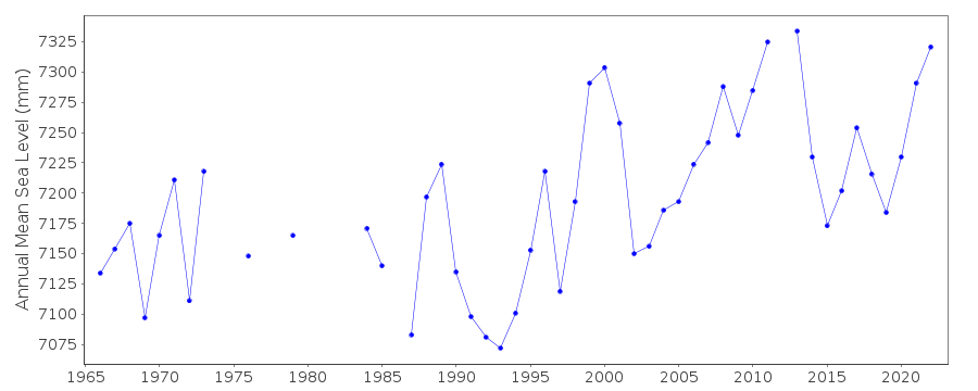 PSMSL Annual Mean Sea Level for '966'  PSMSL Monthly Mean Sea Level for '966' 
|
|
|