 |
SEALEVEL STATION CATALOG (SSC) |
|
|
|
|
|
| Station catalog metadata [edit] | [station overview] |
|---|
| SSC ID | SSC-prat | | Station Name | Capitan Prat Base | | Country | Chile | | Latitude | -62.479267 | | Longitude | -59.662899 | | DateLastModified | 2025-05-08 22:03:44 |
| Linked codes |
|---|
| Codes | Location | Latitude | Longitude | Sensors | IOC: prat | Base Naval Capitan Arturo Prat CL | -62.479267 | -59.662899 | prs, pr2, bat |
IOC: prat3 | Base Naval Capitan Arturo Prat CL | -62.479267 | -59.662899 | prs, rad |
GLOSS: 189 | Capitan Prat Base (Antarctica) | -62.29 | -59.38 | Pressure |
UHSLC: 730 | Base Prat | -62.483 | -59.667 | N/A |
PTWC: pra2 | Antarctica_Base_Prat_CL | -62.4793 | -59.6620 | prs, rad |
PTWC: prat | Antarctica_Base_Prat_CL | -62.4793 | -59.6620 | pr2, prs |
PSMSL: 1603 | PUERTO SOBERANIA | -62.483333 | -59.633333 | N/A |
SONEL_TG: 2862 | PUERTO SOBERANIA | -62.47973300 | -59.66507100 | N/A |
| Distributed metadata source: IOC Sea Level Station Monitoring Facility prat |
|---|
| GTS station code | ADC11960 |
| GTS message type | SXCH40 |
| Status | Operational |
| Local Contact | Servicio Hidrográfico y Oceanográfico de la Armada ( Chile ) |
| Other Contact | Servicio Hidrográfico y Oceanográfico de la Armada ( Chile ) |
| Connection | GTS message |
| Country | Chile |
| Sensor 1 | |
| Type of sensor | prs |
| Sampling rate (min) | 1 |
| Sensor 2 | |
| Type of sensor | pr2 |
| Sampling rate (min) | 1 |
| Sensor 3 | |
| Type of sensor | bat |
| Sampling rate (min) | 5 |
| Distributed metadata source: IOC Sea Level Station Monitoring Facility prat3 |
|---|
| Status | Operational |
| Local Contact | Servicio Hidrográfico y Oceanográfico de la Armada ( Chile ) |
| Other Contact | Servicio Hidrográfico y Oceanográfico de la Armada ( Chile ) |
| Connection | WEB service |
| Country | Chile |
| Sensor 1 | |
| Type of sensor | prs |
| Sampling rate (min) | 1 |
| Sensor 2 | |
| Type of sensor | rad |
| Sampling rate (min) | 1 |
| Distributed metadata source: GLOSS Station Handbook |
|---|
| Time Zone | 060W, GMT - 4hrs | | Ocean | Southern | | Operational | Yes | | Responsible country | Chile | | Data acquisition rate | 20 minute intervals | | Additional parameters | Sea temperature (daily) | | Tide gauge benchmarks | BM No. 1: It is a 6cm bronze disk stamped CF 1, set in cement at the right of the main entrance to the 'Base Naval Antartica-Arturo Prat' building | | Benchmark relationships | BM No. 1 (1983-2003)
BM No. 3 (1983-2003)
BM No. 4 (1983-2003) | | Auxiliary benchmarks | BM No. 3: It is a 6cm bronze disk stamped CF 3, set in cement at the upper part of the visible rock located 40m NW of the 'Base Naval Antartica-Arturo Prat' building.
BM No. 4: It is a 6cm bronze disk stamped CF 4, set in cement at the upper part of the visible rock located 20m NW of BM No. 3. | | Other relevant information | Levelling once a year, no GPS recording. | | Other relevant codes | UHSLC 730 | | Nearest Met. station | Base Prat |
| Distributed metadata source: PTWC COMP META file |
| DCP ID | 1234ABF4 |
| WMO | FTPIO0 |
| Samp Rate | 1 |
| Num# Samp | 5 |
| Unit | M |
| Scale | 1.0000 |
| Xmt Int. | 005 |
| Fst Min. | 0002 |
| HAR | 1 |
| Owner | SHOA |
| Distributed metadata source: UHSLC |
| UHSLC id | 730 |
| SSC id | prat |
| GLOSS id | 189 |
| UHSLC geojson | https://uhslc.soest.hawaii.edu/data/meta.geojson |
| Research quality data version a | 1984-03-08 - 2002-12-31 |
| Research quality data version b | 2010-03-10 - 2018-12-31 |
| RQ basin | atlantic |
| Fast delivery | 2010-03-10 - 2024-08-31 |
| Distributed metadata source: PSMSL |
| Name | PUERTO SOBERANIA |
| GLOSS id | 189 |
| UHSLC ID | 730 |
| Is RLR | Y |
| Has RLR Diagram | Y link |
| QC Flag | N |
| Old ID | 999/005 |
| Last Updated | 2022-10-10 |
| Supplier | HYDROGRAPHIC AND OCEANOGRAPHIC SERVICE OF THE CHILEAN NAVY |
| Address | Hydrographic and Oceanographic Service of the Chilean Navy, Errazuriz 254, Playa Ancha , Valparaiso, CHILE |
| Metric Start | 1984 |
| Metric End | 2020 |
| Metric Completeness | 55.9 |
| RLR Start | 1984 |
| RLR End | 2020 |
| RLR Completeness | 55.9 |
| Download metric sea level data. | Use only with extreme caution. |
IOC Sea Level Station Monitoring Facility - realtime graph for 'prat' 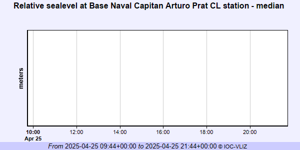 IOC Sea Level Station Monitoring Facility - realtime graph for 'prat3' 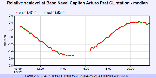 PSMSL Annual Mean Sea Level for '1603'  PSMSL Monthly Mean Sea Level for '1603' 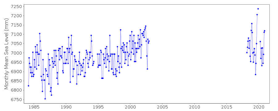
|
|
|