 |
SEALEVEL STATION CATALOG (SSC) |
|
|
|
|
|
| Station catalog metadata [edit] | [station overview] |
|---|
| SSC ID | SSC-porl | | Station Name | Portland | | Country | Australia | | Latitude | -38.3434 | | Longitude | 141.6132 | | DateLastModified | 2015-10-22 19:02:29 |
| Distributed metadata source: IOC Sea Level Station Monitoring Facility porl |
|---|
| GTS station code | 61410 |
| GTS message type | SZAU01 |
| Status | Operational |
| Local Contact | National Tidal Centre/Australian Bureau of Meteorology ( Australia ) |
| Connection | GTS message |
| Country | Australia |
| Sensor 1 | |
| Type of sensor | aqu |
| Sampling rate (min) | 1 |
| Distributed metadata source: GLOSS Station Handbook |
|---|
| Time Zone | 150E, GMT + 10hrs | | Ocean | Southern | | Operational | Yes | | Responsible country | Australia | | Data acquisition rate | 6 minute interval | | Additional parameters | Barometric pressure, water/air temperature, wind speed and direction | | Tide gauge benchmarks | Portland (PM) 390 / BM38-81 3D Brass pin in concrete at the northern end of the K S Anderson Wharf 3D 2.943m above the Australian Height Datum and 3.450m above Chart Datum. | | Benchmark relationships | Zero of tide staff is 0.022m below Tide Gauge Zero (TGZ) and 0.507m below the Australian Height Datum
TGZ is 3.426m below PM386.
TGZ is 2.820m below PM298.
Chart Datum is 0.014m below TGZ and 0.507m below the Australian Height Datum (AHD).
| | Auxiliary benchmarks | Portland (PM) 386
Portland (PM) 387 (HSM) /1464-2H = 3.408m AHD
Portland (PM) 298
Portland (PM) 378 (HSM)
Portland (PM) 116 / GBM103 = datum for AHD heights = 8.662m AHD
Portland (PM) 393 / P203-1H = Coastal Array; Primary BM = 3.517m AHD
Portland (PM) 238
Portland (PM) 388
Portland (PM) 239
Portland (PM) 389
Portland (PM) 390
SEAFRAME Sensor BM = 2.918m AHD
| | Other relevant information | PSMSL also hold data from another gauge at Portland (PSMSL Code 680/232: 1982-1990). | | Other relevant codes | NTF port no. 61410 | | Nearest Met. station | Adelaide Airport |
| Distributed metadata source: PTWC COMP META file |
| DCP ID | 61410 |
| WMO | SZAU01 |
| Samp Rate | 1 |
| Num# Samp | 6 |
| Unit | M |
| Scale | 1.0000 |
| Xmt Int. | 003 |
| Fst Min. | 0000 |
| HAR | 1 |
| Owner | ABM |
| Distributed metadata source: UHSLC |
| UHSLC id | 129 |
| SSC id | porl |
| GLOSS id | 55 |
| UHSLC geojson | https://uhslc.soest.hawaii.edu/data/meta.geojson |
| Research quality data version a | 1991-01-01 - 2021-12-31 |
| RQ basin | indian |
| Fast delivery | 1991-01-01 - 2026-04-30 |
| Distributed metadata source: PSMSL |
| Name | PORTLAND |
| GLOSS id | 55 |
| UHSLC ID | 129 |
| SONEL id | 2061 |
| Is RLR | Y |
| Has RLR Diagram | Y link |
| QC Flag | N |
| Old ID | 680/231 |
| Last Updated | 2025-03-20 |
| Supplier | NATIONAL TIDAL CENTRE |
| Address | National Tidal Centre, Bureau of Meteorology, PO Box 421, Kent Town 5071, South Australia, AUSTRALIA |
| Metric Start | 1982 |
| Metric End | 2025 |
| Metric Completeness | 96.6 |
| RLR Start | 1992 |
| RLR End | 2025 |
| RLR Completeness | 96.8 |
| Download metric sea level data. | Use only with extreme caution. |
| Name | PORTLAND II |
| GLOSS id | 55 |
| UHSLC ID | 129 |
| Is RLR | N |
| Has RLR Diagram | N link |
| QC Flag | N |
| Old ID | 680/232 |
| Last Updated | 1993-05-24 |
| Supplier | NATIONAL TIDAL FACILITY |
| Address | National Tidal Facility, G.P.O. Box 2100, S.A. 5001, Adelaide , AUSTRALIA |
| Metric Start | 1982 |
| Metric End | 1990 |
| Metric Completeness | 95.4 |
| Download metric sea level data. | Use only with extreme caution. |
IOC Sea Level Station Monitoring Facility - realtime graph for 'porl' 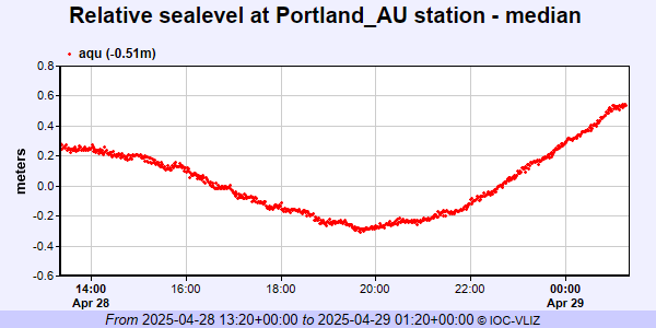 PSMSL Annual Mean Sea Level for '1547' 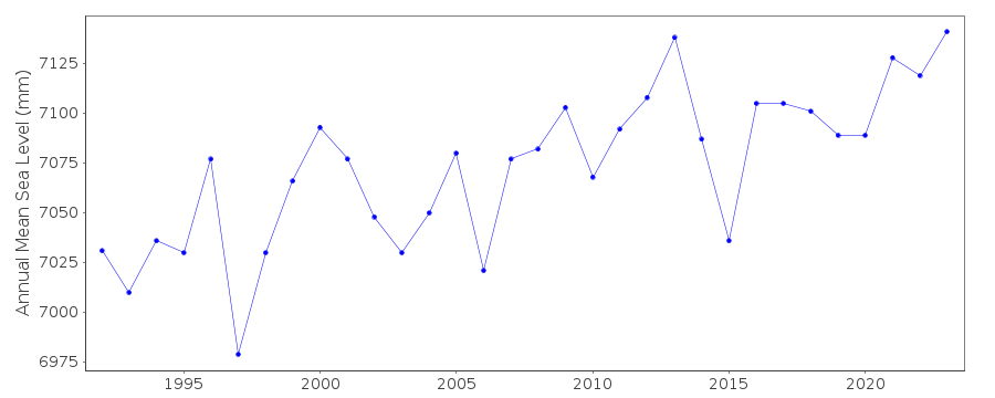 PSMSL Annual Mean Sea Level for '1556'  PSMSL Monthly Mean Sea Level for '1556' 
|
|
|