 |
SEALEVEL STATION CATALOG (SSC) |
|
|
|
|
|
| Station catalog metadata [edit] | [station overview] |
|---|
| SSC ID | SSC-porf | | Station Name | Port Orford | | Country | United States | | Latitude | 42.737 | | Longitude | -124.497 | | DateLastModified | 2015-10-22 19:02:29 |
| Linked codes |
|---|
| Codes | Location | Latitude | Longitude | Sensors | IOC: porf | Port_Orford_OR | 42.737 | -124.497 | pwl, bwl |
UHSLC: 557 | Port Orford, OR | 42.74 | -124.497 | N/A |
PTWC: porf | Port_Orford_OR | 42.7390 | -124.4980 | pwc, pwl, bwl |
PSMSL: 1640 | PORT ORFORD | 42.738333 | -124.498333 | N/A |
SONEL_GPS: 2713 | PORT ORFORD | 42.83609900 | -124.56334500 | N/A |
SONEL_TG: 2712 | PORT ORFORD | 42.73912800 | -124.49855200 | N/A |
| Distributed metadata source: IOC Sea Level Station Monitoring Facility porf |
|---|
| GTS station code | 33685250 |
| GTS message type | SXXX03 |
| Status | Operational |
| Local Contact | National Ocean Service-NOAA ( USA ) |
| Country | USA |
| Sensor 1 | |
| Type of sensor | pwl |
| Sampling rate (min) | 1 |
| Sensor 2 | |
| Type of sensor | bwl |
| Sampling rate (min) | 6 |
| Distributed metadata source: PTWC COMP META file |
| DCP ID | 33685250 |
| WMO | SXXX03 |
| Samp Rate | 6 |
| Num# Samp | 1 |
| Unit | M |
| Scale | 1.3825 |
| Xmt Int. | 006 |
| Fst Min. | 0015 |
| HAR | 1 |
| Owner | NOS |
| Distributed metadata source: UHSLC |
| UHSLC id | 557 |
| SSC id | porf |
| UHSLC geojson | https://uhslc.soest.hawaii.edu/data/meta.geojson |
| Research quality data version a | 1978-08-02 - 2022-12-31 |
| RQ basin | pacific |
| Distributed metadata source: PSMSL |
| Name | PORT ORFORD |
| UHSLC ID | 557 |
| SONEL id | 2713 |
| Is RLR | Y |
| Has RLR Diagram | Y link |
| QC Flag | N |
| Old ID | 823/020 |
| Last Updated | 2026-01-28 |
| Supplier | N.O.A.A. / N.O.S. |
| Address | N.O.A.A. / N.O.S., N/oes33, Ssmc4, Room 6531, 1305 East-West Highway, Silver Spring, , MD 20910, UNITED STATES |
| Metric Start | 1985 |
| Metric End | 2025 |
| Metric Completeness | 91.1 |
| RLR Start | 1985 |
| RLR End | 2025 |
| RLR Completeness | 91.1 |
| Download metric sea level data. | Use only with extreme caution. |
IOC Sea Level Station Monitoring Facility - realtime graph for 'porf'  PSMSL Annual Mean Sea Level for '1640' 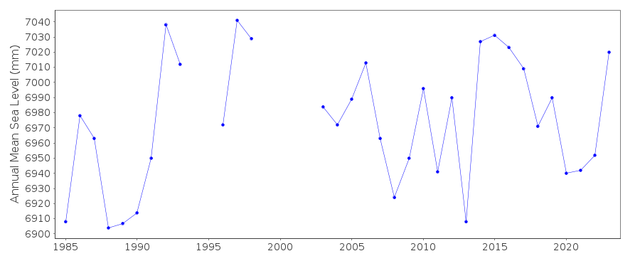 PSMSL Monthly Mean Sea Level for '1640' 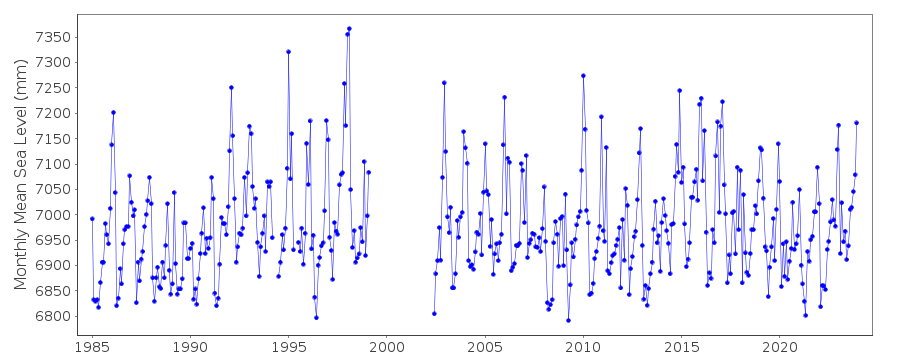
|
|
|