 |
SEALEVEL STATION CATALOG (SSC) |
|
|
|
|
|
| Station catalog metadata [edit] | [station overview] |
|---|
| SSC ID | SSC-pnfl | | Station Name | Pensacola | | Country | United States | | Latitude | 30.403 | | Longitude | -87.212 | | DateLastModified | 2015-10-22 19:02:29 |
| Linked codes |
|---|
| Codes | Location | Latitude | Longitude | Sensors | IOC: pnfl | Pensacola_FL | 30.403 | -87.212 | wls |
IOC: pnfl2 | Pensacola_FL | 30.403 | -87.212 | pwl |
GLOSS: 288 | Pensacola, FL | 30.4 | -87.21666 | Float, Pressure, Bubbler |
UHSLC: 762 | Pensacola, FL | 30.403 | -87.213 | N/A |
PTWC: pnfl | Pensacola_FL | 30.4044 | -87.2112 | pwc, pwl, bwl |
PSMSL: 246 | PENSACOLA | 30.403333 | -87.21 | N/A |
SONEL_GPS: 1887 | PENSACOLA | 30.46899605 | -87.18939972 | N/A |
SONEL_TG: 2379 | PENSACOLA | 30.40378600 | -87.21141400 | N/A |
| Distributed metadata source: IOC Sea Level Station Monitoring Facility pnfl |
|---|
| GTS station code | 33A02AD0 |
| GTS message type | SXXX03 |
| Status | Operational |
| Local Contact | National Ocean Service-NOAA ( USA ) |
| Connection | WEB service |
| Country | USA |
| Sensor 1 | |
| Type of sensor | wls |
| Sampling rate (min) | 6 |
| Distributed metadata source: IOC Sea Level Station Monitoring Facility pnfl2 |
|---|
| GTS station code | 33A02AD0 |
| GTS message type | SXXX03 |
| Status | Operational |
| Local Contact | National Ocean Service-NOAA ( USA ) |
| Connection | GTS message |
| Country | USA |
| Sensor 1 | |
| Type of sensor | pwl |
| Sampling rate (min) | 1 |
| Distributed metadata source: GLOSS Station Handbook |
|---|
| Time Zone | 090W, GMT - 6hrs | | Ocean | Atlantic | | Operational | Yes | | Data acquisition rate | 6 minute intervals | | Tide gauge benchmarks | US C&GS tidal benchmark survey disk stamped '8 1923' set vertically in the concrete foundation wall of the City Hall Building at the corner of Jefferson and E. Zaragoza Streets. | | Benchmark relationships | TGBM = 13.04 feet above mean lower low water (1960-1978 epoch)
TGBM = 12.42 feet above mean sea level (1960-1978 epoch)
TGBM = 11.81 feet above mean high water (1960-1978 epoch)
TGBM is 15.694ft above tide staff zero
| | Auxiliary benchmarks | NO 1 1972 11 1923 (13.990ft above tide gauge zero)
NO 2 9840 K 1977 (11.265ft above tide staff zero)
12 1923 9840 L 1978
G 9 1918 13.271
9840 M 1978 (8.708ft above tide staff zero)
9840 N 1978 (11.737ft above tide gauge zero)
9840 A 1978
| | Other relevant codes | UHSLC 762 |
| Distributed metadata source: PTWC COMP META file |
| DCP ID | 33A02AD0 |
| WMO | SXXX03 |
| Samp Rate | 6 |
| Num# Samp | 1 |
| Unit | M |
| Scale | 1.3950 |
| Xmt Int. | 006 |
| Fst Min. | 0004 |
| HAR | 0 |
| Owner | NOS |
| Distributed metadata source: UHSLC |
| UHSLC id | 762 |
| SSC id | pnfl |
| GLOSS id | 288 |
| UHSLC geojson | https://uhslc.soest.hawaii.edu/data/meta.geojson |
| Research quality data version a | 1923-05-02 - 2021-12-31 |
| RQ basin | atlantic |
| Fast delivery | 1923-05-02 - 2026-04-30 |
| Distributed metadata source: PSMSL |
| Name | PENSACOLA |
| GLOSS id | 288 |
| UHSLC ID | 762 |
| SONEL id | 1887 |
| Is RLR | Y |
| Has RLR Diagram | Y link |
| QC Flag | N |
| Old ID | 940/041 |
| Last Updated | 2026-01-27 |
| Supplier | N.O.A.A. / N.O.S. |
| Address | N.O.A.A. / N.O.S., N/oes33, Ssmc4, Room 6531, 1305 East-West Highway, Silver Spring, , MD 20910, UNITED STATES |
| Metric Start | 1923 |
| Metric End | 2025 |
| Metric Completeness | 98.4 |
| RLR Start | 1923 |
| RLR End | 2025 |
| RLR Completeness | 98.4 |
| Download metric sea level data. | Use only with extreme caution. |
IOC Sea Level Station Monitoring Facility - realtime graph for 'pnfl' 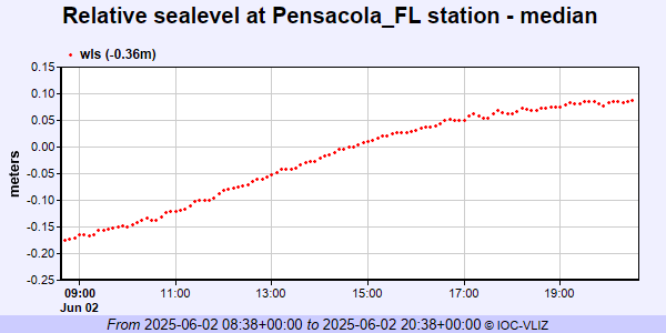 IOC Sea Level Station Monitoring Facility - realtime graph for 'pnfl2' 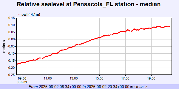 PSMSL Annual Mean Sea Level for '246' 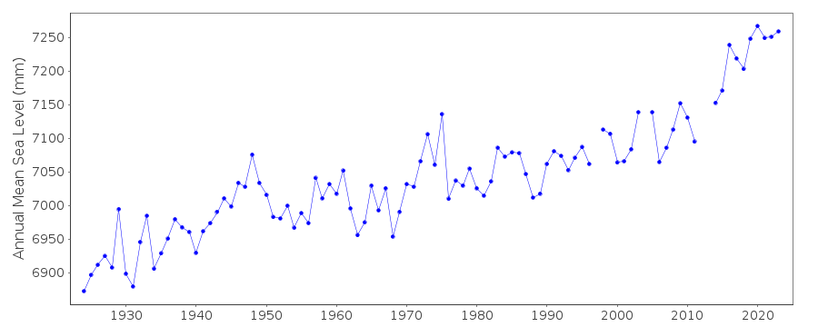 PSMSL Monthly Mean Sea Level for '246' 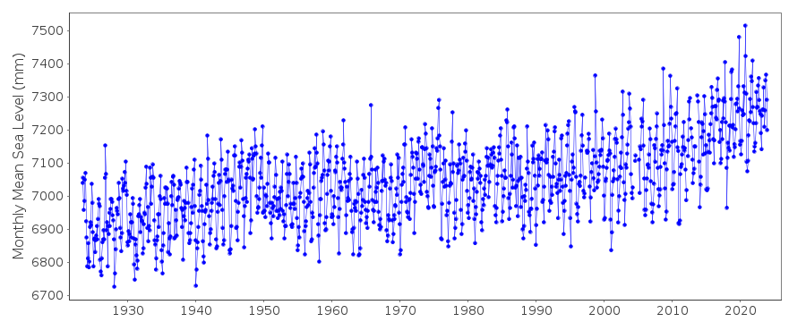
|
|
|