 |
SEALEVEL STATION CATALOG (SSC) |
|
|
|
|
|
| Station catalog metadata [edit] | [station overview] |
|---|
| SSC ID | SSC-pmon | | Station Name | Puerto Montt | | Country | Chile | | Latitude | -41.4833 | | Longitude | -72.9666 | | DateLastModified | 2015-10-22 19:02:29 |
| Linked codes |
|---|
| Codes | Location | Latitude | Longitude | Sensors | IOC: pmon | Puerto Montt (Chile) | -41.484931 | -72.960858 | ra2, rad |
IOC: pmon2 | Puerto Montt (Chile) | -41.484931 | -72.960858 | prs, rad |
GLOSS: 178 | Puerto Montt | -41.29 | -72.58 | Pressure |
UHSLC: 684 | Puerto Montt | -41.483 | -72.967 | N/A |
PTWC: pmon | Puerto_Montt_CL | -41.4849 | -72.9609 | prs, rad |
PSMSL: 472 | PUERTO MONTT | -41.485 | -72.960833 | N/A |
SONEL_TG: 2858 | PUERTO MONTT | -41.48276400 | -72.95450100 | N/A |
| Distributed metadata source: IOC Sea Level Station Monitoring Facility pmon |
|---|
| GTS station code | ADC0CDF2 |
| GTS message type | SXCH40 |
| Status | Operational |
| Local Contact | Servicio Hidrográfico y Oceanográfico de la Armada ( Chile ) |
| Other Contact | Servicio Hidrográfico y Oceanográfico de la Armada ( Chile ) |
| Connection | GTS message |
| Country | Chile |
| Sensor 1 | |
| Type of sensor | ra2 |
| Sampling rate (min) | 1 |
| Sensor 2 | |
| Type of sensor | rad |
| Sampling rate (min) | 1 |
| Distributed metadata source: IOC Sea Level Station Monitoring Facility pmon2 |
|---|
| Status | Operational |
| Local Contact | Servicio Hidrográfico y Oceanográfico de la Armada ( Chile ) |
| Other Contact | Servicio Hidrográfico y Oceanográfico de la Armada ( Chile ) |
| Connection | WEB service |
| Country | Chile |
| Sensor 1 | |
| Type of sensor | prs |
| Sampling rate (min) | 1 |
| Sensor 2 | |
| Type of sensor | rad |
| Sampling rate (min) | 1 |
| Distributed metadata source: GLOSS Station Handbook |
|---|
| Time Zone | 060W, GMT - 4hrs | | Ocean | Pacific | | Operational | Yes | | Responsible country | Chile | | Data acquisition rate | 2 minute intervals | | Additional parameters | Sea temperature (hourly)
Air temperature (hourly)
Atmospheric pressure (hourly) | | Tide gauge benchmarks | BM No. 25 - It is a 6cm bronze disk stamped CF25, set in cement 2.5m north east of the lighthouse at the entrance port. | | Benchmark relationships | BM No. 25 (1958-2003)
BM No. 28 (1980-2003)
BM No. 27 (1980-2003)
BM No. A1 (1999-2003)
BM No. B1 (1999-2003) | | Auxiliary benchmarks | BM No. 28 - it is a 6cm bronze disk stamped CF28 set in cement at the north east corner of the warehouse No. 1 of 'Emporchi'.
BM No. A1: Tide gauge new location. It is a bronze disk stamped A1, set in cement close to the edge of the Navy Pier.
BM No. B1: Tide gauge new location. It is a bronze disk stamped B1, set in cement at the left side of the vehicle gate to 'Gobernacion Maritima' building. | | Other relevant information | Levelling twice a year
No GPS recording
Tide gauge moved to 'Gobernacion Maritima' new building. | | Other relevant codes | UHSLC 684 | | Nearest Met. station | El Tepual Airport |
| Distributed metadata source: PTWC COMP META file |
| DCP ID | ADC0CDF2 |
| WMO | SXCH40 |
| Samp Rate | 1 |
| Num# Samp | 5 |
| Unit | M |
| Scale | 1.0000 |
| Xmt Int. | 005 |
| Fst Min. | 0004 |
| HAR | 1 |
| Owner | SHOA |
| Distributed metadata source: UHSLC |
| UHSLC id | 684 |
| SSC id | pmon |
| GLOSS id | 178 |
| UHSLC geojson | https://uhslc.soest.hawaii.edu/data/meta.geojson |
| Research quality data version a | 1980-04-03 - 2018-12-31 |
| RQ basin | pacific |
| Fast delivery | 1980-04-03 - 2024-04-02 |
| Distributed metadata source: PSMSL |
| Name | PUERTO MONTT |
| GLOSS id | 178 |
| UHSLC ID | 684 |
| Is RLR | N |
| Has RLR Diagram | N link |
| QC Flag | N |
| Old ID | 850/051 |
| Last Updated | 2025-06-09 |
| Supplier | HYDROGRAPHIC AND OCEANOGRAPHIC SERVICE OF THE CHILEAN NAVY |
| Address | Hydrographic and Oceanographic Service of the Chilean Navy, Errazuriz 254, Playa Ancha , Valparaiso, CHILE |
| Metric Start | 1942 |
| Metric End | 2024 |
| Metric Completeness | 74.2 |
| Download metric sea level data. | Use only with extreme caution. |
IOC Sea Level Station Monitoring Facility - realtime graph for 'pmon' 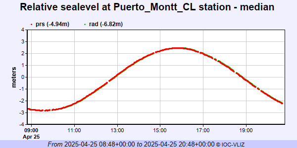 IOC Sea Level Station Monitoring Facility - realtime graph for 'pmon2' 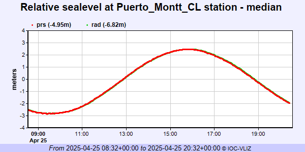 PSMSL Annual Mean Sea Level for '472'  PSMSL Monthly Mean Sea Level for '472' 
|
|
|