| Station catalog metadata [edit] | [station overview] |
|---|
| SSC ID | SSC-plat | | Station Name | Mar Del Plata | | Country | Argentina | | Latitude | -38.05 | | Longitude | -57.55 | | DateLastModified | 2015-10-22 19:02:29 |
| Linked codes |
|---|
| Codes | Location | Latitude | Longitude | Sensors | IOC: plat | Mar_Del_Plata | -38.05 | -57.55 | ecs |
IOC: plat2 | Mar del Plata | -38.00015278 | -57.53850556 | rad, ra2, ra3, sw1, bat, sw2 |
GLOSS: 192 | Mar del Plata | -38.05 | -57.55 | Float, Bubbler, Acoustic |
UHSLC: 729 | Mar del Plata | -38.035 | -57.538 | N/A |
PTWC: plat | Mar_Del_Plata_AR | -38.0001 | -57.5385 | ra3, rad |
PSMSL: 177 | MAR DEL PLATA | -38.05 | -57.55 | N/A |
PSMSL: 1852 | MAR DEL PLATA 2 | -38.0 | -57.55 | N/A |
PSMSL: 819 | MAR DEL PLATA (CLUB) | -38.033333 | -57.516667 | N/A |
PSMSL: 857 | MAR DEL PLATA (PUERTO) | -38.033333 | -57.533333 | N/A |
SONEL_GPS: 2051 | MAR DEL PLATA | -38.00576684 | -57.57129759 | N/A |
SONEL_GPS: 937 | MAR DEL PLATA | -38.03560401 | -57.53114196 | N/A |
SONEL_TG: 2369 | MAR DEL PLATA | -38.03564600 | -57.53107300 | N/A |
SONEL_TG: 2758 | MAR DEL PLATA | -38.03333300 | -57.53333300 | N/A |
| Distributed metadata source: IOC Sea Level Station Monitoring Facility plat |
|---|
| GTS station code | 3542B4D2 |
| GTS message type | SXXX50 |
| Status | Down |
| Local Contact | Armada Argentina Servicio de Hidrografía Naval ( Argentina ) |
| Connection | GTS message |
| Country | Argentina |
| Sensor 1 | |
| Type of sensor | ecs |
| Sampling rate (min) | 6 |
| Distributed metadata source: IOC Sea Level Station Monitoring Facility plat2 |
|---|
| GTS station code | 300434064787550 |
| GTS message type | SZXX01 |
| Status | Operational |
| Local Contact | Armada Argentina Servicio de Hidrografía Naval ( Argentina ) |
| Other Contact | University of Hawaii Sea Level Center ( USA ) |
| Connection | GTS message |
| Country | Argentina |
| Sensor 1 | |
| Type of sensor | rad |
| Sampling rate (min) | 1 |
| Sensor 2 | |
| Type of sensor | ra2 |
| Sampling rate (min) | 3 |
| Sensor 3 | |
| Type of sensor | ra3 |
| Sampling rate (min) | 1 |
| Sensor 4 | |
| Type of sensor | sw1 |
| Sampling rate (min) | 60 |
| Sensor 5 | |
| Type of sensor | bat |
| Sampling rate (min) | 5 |
| Sensor 6 | |
| Type of sensor | sw2 |
| Sampling rate (min) | 60 |
| Distributed metadata source: GLOSS Station Handbook |
|---|
| Time Zone | 060W, GMT - 4hrs | | Ocean | Atlantic | | Operational | Yes | | Responsible country | Argentina | | Additional parameters | Wind speed/direction/gust, air & water temp., air pressure | | Tide gauge benchmarks | Benchmark bolt inside tide gauge hut adjacent to stilling well.
Acoustic gauge is referred to the same benchmark as the float gauge.
Aquatrack Levelling Point designated as 10.000m above an arbitrary zero.
| | Benchmark relationships | Tide gauge zero (TGZ) = local chart datum
TGZ = 0.91m below 'O' IGM
TGZ = 5.74m below TGBM (from 1949 onwards)
NOAA Gauge O designated exactly two metres below chart zero. Chart zero refers to MLLW as on the Plano de Reduccion de la Carta Argentina.
| | Auxiliary benchmarks | AUX 1: Punto fijo No. 11, AUX 1: Punto fijo No. 11, ubicado al pie de la cuarta columna, contando desde la entrade, en el muelle del Club de Pescadores de Mar del Plata.
Other benchmarks include: SIHN 2020 A 1992, 166, PN10, NO 6 1948, PF VINCULO.
ubicado al pie de la cuarta columna, contando desde la entrade, en el muelle del Club de Pescadores de Mar del Plata. | | Other relevant information | Data for other gauges at Mar del Plata (PSMSL Code 860/111 1910-1913, 1915-1946) and at Puerto (PSMSL Code 860/091 1957-1967, 1971-1980) are held by PSMSL.
Since 1980, Servicio de Hidrografia Naval keeps operational the Mar del Plata Club station only. Its benchmarks are mentioned above.
|
| Distributed metadata source: PTWC COMP META file |
| DCP ID | 300434064787550 |
| WMO | SZXX01 |
| Samp Rate | 1 |
| Num# Samp | 5 |
| Unit | M |
| Scale | 1.0000 |
| Xmt Int. | 005 |
| Fst Min. | 0001 |
| HAR | 1 |
| Owner | SHN |
| Distributed metadata source: UHSLC |
| UHSLC id | 729 |
| SSC id | plat |
| GLOSS id | 192 |
| UHSLC geojson | https://uhslc.soest.hawaii.edu/data/meta.geojson |
| Research quality data version a | 2004-11-15 - 2009-01-29 |
| Research quality data version b | 2010-03-24 - 2018-12-31 |
| RQ basin | atlantic |
| Fast delivery | 2010-03-24 - 2026-04-30 |
| Distributed metadata source: PSMSL |
| Name | MAR DEL PLATA |
| GLOSS id | 192 |
| UHSLC ID | 729 |
| Is RLR | N |
| Has RLR Diagram | N link |
| QC Flag | N |
| Old ID | 860/111 |
| Last Updated | null |
| Supplier | SERVICIO DE HIDROGRAFIA NAVAL, ARGENTINA |
| Address | Servicio de Hidrografia Naval, Departmento Oceanografia, Av. Montes de Oca 2124, 1271 Buenos Aires, ARGENTINA |
| Metric Start | 1910 |
| Metric End | 1946 |
| Metric Completeness | 93.2 |
| Download metric sea level data. | Use only with extreme caution. |
| Name | MAR DEL PLATA 2 |
| GLOSS id | 192 |
| UHSLC ID | 729 |
| Is RLR | N |
| Has RLR Diagram | N link |
| QC Flag | N |
| Old ID | 860/105 |
| Last Updated | 1995-11-20 |
| Supplier | N.O.A.A. / N.O.S. |
| Address | N.O.A.A. / N.O.S., N/oes33, Ssmc4, Room 6531, 1305 East-West Highway, Silver Spring, , MD 20910, UNITED STATES |
| Metric Start | 1993 |
| Metric End | 1994 |
| Metric Completeness | 83.3 |
| Download metric sea level data. | Use only with extreme caution. |
| Name | MAR DEL PLATA (CLUB) |
| GLOSS id | 192 |
| UHSLC ID | 729 |
| SONEL id | 937 |
| Is RLR | Y |
| Has RLR Diagram | Y link |
| QC Flag | N |
| Old ID | 860/101 |
| Last Updated | 2023-02-01 |
| Supplier | SERVICIO DE HIDROGRAFIA NAVAL, ARGENTINA |
| Address | Servicio de Hidrografia Naval, Departmento Oceanografia, Av. Montes de Oca 2124, 1271 Buenos Aires, ARGENTINA |
| Metric Start | 1957 |
| Metric End | 2022 |
| Metric Completeness | 95.5 |
| RLR Start | 1957 |
| RLR End | 2022 |
| RLR Completeness | 95.5 |
| Download metric sea level data. | Use only with extreme caution. |
| Name | MAR DEL PLATA (PUERTO) |
| GLOSS id | 192 |
| UHSLC ID | 729 |
| SONEL id | 937 |
| Is RLR | Y |
| Has RLR Diagram | Y link |
| QC Flag | N |
| Old ID | 860/091 |
| Last Updated | null |
| Supplier | SERVICIO DE HIDROGRAFIA NAVAL, ARGENTINA |
| Address | Servicio de Hidrografia Naval, Departmento Oceanografia, Av. Montes de Oca 2124, 1271 Buenos Aires, ARGENTINA |
| Metric Start | 1957 |
| Metric End | 1980 |
| Metric Completeness | 81.6 |
| RLR Start | 1957 |
| RLR End | 1980 |
| RLR Completeness | 81.6 |
| Download metric sea level data. | Use only with extreme caution. |
IOC Sea Level Station Monitoring Facility - realtime graph for 'plat'  IOC Sea Level Station Monitoring Facility - realtime graph for 'plat2' 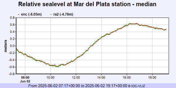 PSMSL Annual Mean Sea Level for '177'  PSMSL Annual Mean Sea Level for '1852'  PSMSL Annual Mean Sea Level for '819' 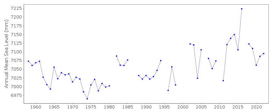 PSMSL Annual Mean Sea Level for '857' 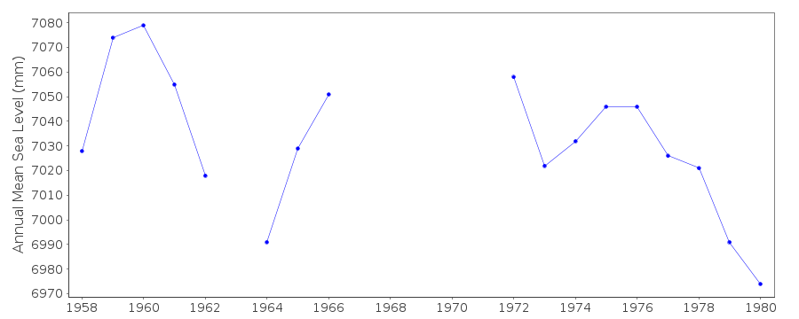 PSMSL Monthly Mean Sea Level for '857' 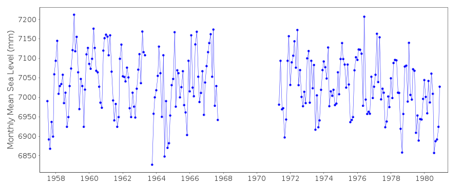
|
