| Station catalog metadata [edit] | [station overview] |
|---|
| SSC ID | SSC-pape | | Station Name | Pape'ete | | Country | France | | Latitude | -17.533092 | | Longitude | -149.572678 | | DateLastModified | 2023-02-22 21:17:43 |
| Linked codes |
|---|
| Codes | Location | Latitude | Longitude | Sensors | IOC: pape | Papeete (Tahiti, French Polynesia) | -17.533092 | -149.572678 | prs, rad, ra2, bat, sw1, sw2 |
IOC: pape2 | Papeete (Tahiti, Fare Ute, Shom) | -17.53237 | -149.573165 | rad, bat |
GLOSS: 140 | Papeete, Tahiti | -17.53333 | -149.56666 | Float, Acoustic |
UHSLC: 15 | Papeete | -17.525 | -149.567 | N/A |
UHSLC: 590 | Matavai | -17.517 | -149.517 | N/A |
PTWC: pape | Papeete_Tahiti | -17.5331 | -149.5727 | prs, ra2, rad |
PSMSL: 1260 | PAPEETE-A | -17.533333 | -149.566667 | N/A |
PSMSL: 1397 | PAPEETE-B, FARE UTE POINT, SOC.IS. | -17.533081 | -149.572724 | N/A |
SONEL_GPS: 2203 | PAPEETE | -17.55531237 | -149.61430179 | N/A |
SONEL_GPS: 2204 | PAPEETE | -17.57703100 | -149.60618600 | N/A |
SONEL_GPS: 2205 | PAPEETE | -17.57703100 | -149.60618600 | N/A |
SONEL_GPS: 3096 | PAPEETE | -17.57705833 | -149.60643610 | N/A |
SONEL_GPS: 809 | PAPEETE | -17.53308500 | -149.57271800 | N/A |
SONEL_GPS: 852 | PAPEETE | -17.57690048 | -149.60600281 | N/A |
SONEL_TG: 1820 | PAPEETE | -17.53308500 | -149.57271800 | N/A |
| Distributed metadata source: IOC Sea Level Station Monitoring Facility pape |
|---|
| GTS station code | 301434060198880 |
| GTS message type | SZXX01 |
| Status | Operational |
| Local Contact | Commissariat à l'Energie Atomique ( France ) |
| Other Contact | University of Hawaii Sea Level Center ( USA ) |
| Connection | GTS message |
| Country | France |
| Sensor 1 | |
| Type of sensor | prs |
| Sampling rate (min) | 1 |
| Sensor 2 | |
| Type of sensor | rad |
| Sampling rate (min) | 1 |
| Sensor 3 | |
| Type of sensor | ra2 |
| Sampling rate (min) | 1 |
| Sensor 4 | |
| Type of sensor | bat |
| Sampling rate (min) | 5 |
| Sensor 5 | |
| Type of sensor | sw1 |
| Sampling rate (min) | 60 |
| Sensor 6 | |
| Type of sensor | sw2 |
| Sampling rate (min) | 60 |
| Distributed metadata source: IOC Sea Level Station Monitoring Facility pape2 |
|---|
| GTS station code | FAA031C8 |
| GTS message type | SEHI40 |
| Status | Operational |
| Local Contact | Service hydrographique et océanographique de la marine ( France ) |
| Connection | GTS message |
| Country | Polynésie Française (French Polynesia) |
| Sensor 1 | |
| Type of sensor | rad |
| Sampling rate (min) | 1 |
| Sensor 2 | |
| Type of sensor | bat |
| Sampling rate (min) | 15 |
| Distributed metadata source: GLOSS Station Handbook |
|---|
| Time Zone | 150W, GMT - 10hrs | | Ocean | Pacific | | Operational | Yes | | Additional parameters | Air/sea temperature, barometric pressure, wind sensors | | Tide gauge benchmarks | UH-1A: 1 inch standard disk, no stamp, set in dark grey epoxy, located 35ft east of tide staff at centre of quay, established 07 Apr 1982 | | Auxiliary benchmarks | NU-1: no description available, destroyed prior to 1982
NU-2: no description available (established 22 Sep 1969)
NU-3: no description available, destroyed prior to 1982
O-C: no description available (established Jul 1989)
B: no description available (established Jul 1989)
Also: BM A, BM C, BM D, BM 2, BM 3, BM 4, BM 5, BM 6, BM 7
| | Other relevant information | Daily values calculated using 119-point convolution filter (Bloomfield, 1976) centred on noon applied to the hourly data with respective periods of the 95, 50 and 5% amplitude points at 124.0, 60.2 and 40.2 hours. | | Other relevant codes | UHSLC 015 |
| Distributed metadata source: PTWC COMP META file |
| DCP ID | 301434060198880 |
| WMO | SXXX01 |
| Samp Rate | 1 |
| Num# Samp | 5 |
| Unit | M |
| Scale | 1.0000 |
| Xmt Int. | 005 |
| Fst Min. | 0001 |
| HAR | 1 |
| Owner | UHSLC |
| Distributed metadata source: UHSLC |
| UHSLC id | 015 |
| SSC id | pape |
| GLOSS id | 140 |
| UHSLC geojson | https://uhslc.soest.hawaii.edu/data/meta.geojson |
| Research quality data version a | 1969-05-02 - 1975-05-30 |
| Research quality data version b | 1975-06-09 - 2018-12-31 |
| RQ basin | pacific |
| Fast delivery | 1975-06-09 - 2026-04-30 |
| UHSLC id | 590 |
| SSC id | pape |
| GLOSS id | 140 |
| UHSLC geojson | https://uhslc.soest.hawaii.edu/data/meta.geojson |
| Research quality data version a | 1958-01-01 - 1967-11-26 |
| RQ basin | pacific |
| Distributed metadata source: PSMSL |
| Name | PAPEETE-A |
| GLOSS id | 140 |
| UHSLC ID | 590 |
| Is RLR | N |
| Has RLR Diagram | N link |
| QC Flag | N |
| Old ID | 780/010 |
| Last Updated | 2014-02-26 |
| Supplier | SERVICE HYD. ET OCEAN. DE LA MARINE |
| Address | SHOM, 13 rue de Chatelier, 29200 BREST , FRANCE |
| Metric Start | 1969 |
| Metric End | 1975 |
| Metric Completeness | 85.7 |
| Download metric sea level data. | Use only with extreme caution. |
| Name | PAPEETE-B, FARE UTE POINT, SOC.IS. |
| GLOSS id | 140 |
| UHSLC ID | 590 |
| SONEL id | 3096 |
| Is RLR | Y |
| Has RLR Diagram | Y link |
| QC Flag | N |
| Old ID | 780/011 |
| Last Updated | 2025-06-19 |
| Supplier | UNIVERSITY OF HAWAII SEA LEVEL CENTER |
| Address | University of Hawaii Sea Level Center, Department of Oceanography Division of Natural Sciences, 1000 Pope Road, Honolulu, Hawaii 96822, UNITED STATES |
| Metric Start | 1975 |
| Metric End | 2018 |
| Metric Completeness | 97.2 |
| RLR Start | 1975 |
| RLR End | 2018 |
| RLR Completeness | 97.2 |
| Download metric sea level data. | Use only with extreme caution. |
IOC Sea Level Station Monitoring Facility - realtime graph for 'pape' 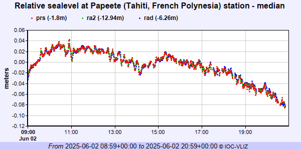 IOC Sea Level Station Monitoring Facility - realtime graph for 'pape2' 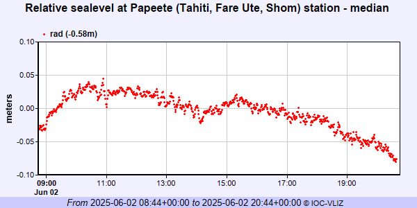 PSMSL Annual Mean Sea Level for '1260'  PSMSL Annual Mean Sea Level for '1397' 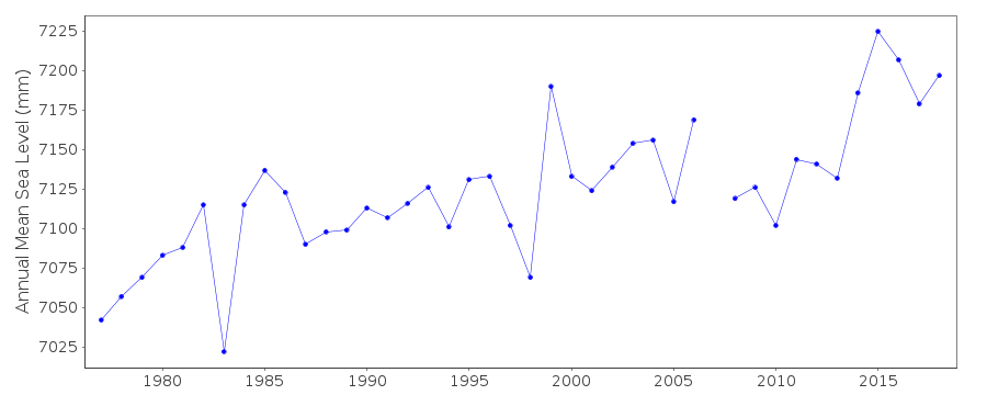 PSMSL Monthly Mean Sea Level for '1397' 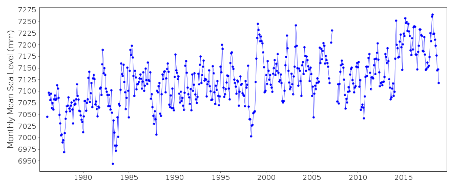
|
