 |
SEALEVEL STATION CATALOG (SSC) |
|
|
|
|
|
| Station catalog metadata [edit] | [station overview] |
|---|
| SSC ID | SSC-pago | | Station Name | Pago Pago | | Country | American Samoa | | Latitude | -14.2766 | | Longitude | -170.6907 | | DateLastModified | 2018-01-22 07:07:15 |
| Linked codes |
|---|
| Codes | Location | Latitude | Longitude | Sensors | IOC: pago | Pago_Pago_AS | -14.2766 | -170.6907 | pwl |
IOC: pago2 | Pago_Pago_AS | -14.2766 | -170.6907 | pwl |
IOC: pagx | Pago_Pago_AS | -14.2766 | -170.6907 | pwl |
GLOSS: 144 | Pago Pago, American Samoa | -14.28333 | -170.68333 | Float, Bubbler, Acoustic |
UHSLC: 56 | Pago Pago | -14.283 | -170.683 | N/A |
PTWC: pago | Pago_Pago_AS | -14.2766 | -170.6890 | pwc, pwl, bwl |
PTWC: pagx | Pago_Pago_AS | -14.2766 | -170.6890 | pwl, bwl |
PSMSL: 539 | PAGO PAGO | -14.28 | -170.69 | N/A |
SONEL_GPS: 631 | AMERICAN SAMOA | -14.32609663 | -170.72243261 | N/A |
SONEL_TG: 2352 | AMERICAN SAMOA | -14.27634200 | -170.68152600 | N/A |
| Distributed metadata source: IOC Sea Level Station Monitoring Facility pago |
|---|
| GTS station code | 336015FC |
| GTS message type | SXXX03 |
| Status | Operational |
| Local Contact | National Ocean Service-NOAA ( USA ) |
| Connection | WEB service |
| Country | Samoa; U.S.A. |
| Sensor 1 | |
| Type of sensor | pwl |
| Sampling rate (min) | 1 |
| Distributed metadata source: IOC Sea Level Station Monitoring Facility pago2 |
|---|
| GTS station code | 336015FC |
| GTS message type | SXXX03 |
| Status | Down |
| Local Contact | National Ocean Service-NOAA ( USA ) |
| Connection | GTS message |
| Country | Samoa; U.S.A. |
| Sensor 1 | |
| Type of sensor | pwl |
| Sampling rate (min) | 1 |
| Distributed metadata source: IOC Sea Level Station Monitoring Facility pagx |
|---|
| GTS station code | NSTP6 |
| GTS message type | SZPA37 |
| Status | Operational |
| Local Contact | National Ocean Service-NOAA ( USA ) |
| Connection | GTS message |
| Country | Samoa; U.S.A. |
| Sensor 1 | |
| Type of sensor | pwl |
| Sampling rate (min) | 1 |
| Distributed metadata source: GLOSS Station Handbook |
|---|
| Time Zone | 165W, GMT - 11hrs | | Ocean | Pacific | | Operational | Yes | | Additional parameters | Sea surface temperature, density, barometric pressure | | Tide gauge benchmarks | Benchmark M 1983 is the primary benchmark stamped '0000 M 1983' set in a bedrock outcrop at the southernmost corner of the wall surrounding the Government Estate. | | Benchmark relationships | TGBM is 13.20ft above Tide Gauge Zero (Station Datum)
NOAA Chart Datum (MLLW) is 2.48ft above Station Datum
Mean Sea Level (1960-1978) is 3.83ft above Station Datum
| | Auxiliary benchmarks | 8 additional benchmarks are levelled to the TGBM and the Tide Station on a yearly basis (BM K, BM 1, BM 13, BM 14, BM N, BM 10, BM P, BM Q).
New benchmarks established (July 1993) BMs R, S, T, U and V.
| | Other relevant information | GPS nearby | | Other relevant codes | UHSLC 056 |
| Distributed metadata source: PTWC COMP META file |
| DCP ID | 33503560 |
| WMO | SXXX03 |
| Samp Rate | 6 |
| Num# Samp | 1 |
| Unit | M |
| Scale | 1.0000 |
| Xmt Int. | 006 |
| Fst Min. | 0006 |
| HAR | 1 |
| Owner | NOS |
| Distributed metadata source: UHSLC |
| UHSLC id | 056 |
| SSC id | pago |
| GLOSS id | 144 |
| UHSLC geojson | https://uhslc.soest.hawaii.edu/data/meta.geojson |
| Research quality data version a | 1948-09-09 - 2019-12-31 |
| RQ basin | pacific |
| Fast delivery | 1948-09-09 - 2026-04-30 |
| Distributed metadata source: PSMSL |
| Name | PAGO PAGO |
| GLOSS id | 144 |
| UHSLC ID | 56 |
| SONEL id | 631 |
| Is RLR | Y |
| Has RLR Diagram | Y link |
| QC Flag | N |
| Old ID | 745/001 |
| Last Updated | 2025-01-23 |
| Supplier | N.O.A.A. / N.O.S. |
| Address | N.O.A.A. / N.O.S., N/oes33, Ssmc4, Room 6531, 1305 East-West Highway, Silver Spring, , MD 20910, UNITED STATES |
| Metric Start | 1948 |
| Metric End | 2024 |
| Metric Completeness | 91.7 |
| RLR Start | 1948 |
| RLR End | 2024 |
| RLR Completeness | 91.7 |
| Download metric sea level data. | Use only with extreme caution. |
IOC Sea Level Station Monitoring Facility - realtime graph for 'pago' 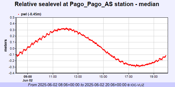 IOC Sea Level Station Monitoring Facility - realtime graph for 'pago2'  IOC Sea Level Station Monitoring Facility - realtime graph for 'pagx'  PSMSL Annual Mean Sea Level for '539'  PSMSL Monthly Mean Sea Level for '539' 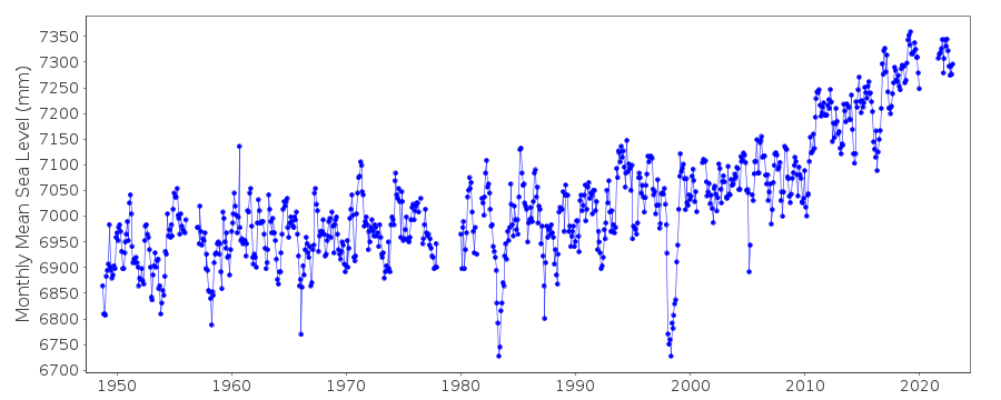
|
|
|