 |
SEALEVEL STATION CATALOG (SSC) |
|
|
|
|
|
| Station catalog metadata [edit] | [station overview] |
|---|
| SSC ID | SSC-olan | | Station Name | Olands Norra Udde | | Country | Sweden | | Latitude | 57.366278 | | Longitude | 17.097228 | | DateLastModified | 2025-01-05 15:20:08 |
| Linked codes |
|---|
| Codes | Location | Latitude | Longitude | Sensors | IOC: olan | Olands norra udde | 57.366111 | 17.097222 | rad |
PSMSL: 69 | OLANDS NORRA UDDE | 57.366111 | 17.097222 | N/A |
SONEL_GPS: 2074 | OLANDS NORRA UDDE | 57.24694722 | 17.05864722 | N/A |
SONEL_TG: 2333 | OLANDS NORRA UDDE | 57.36670000 | 17.10000000 | N/A |
| Distributed metadata source: IOC Sea Level Station Monitoring Facility olan |
|---|
| Status | Operational |
| Local Contact | Swedish Meteorological and Hydrological Institute ( Sweden ) |
| Other Contact | Swedish Maritime Administration ( Sweden ) |
| Connection | WEB service |
| Country | Sweden |
| Sensor 1 | |
| Type of sensor | rad |
| Sampling rate (min) | 1 |
| Distributed metadata source: PSMSL |
| Name | OLANDS NORRA UDDE |
| SONEL id | 2074 |
| Is RLR | Y |
| Has RLR Diagram | Y link |
| QC Flag | N |
| Old ID | 050/091 |
| Last Updated | 2025-05-27 |
| Supplier | SWEDISH MET. AND HYD. INSTITUTE |
| Address | Swedish Met. and Hyd. Institute, Box 923, S601 76 Norrkoping, SWEDEN |
| Metric Start | 1887 |
| Metric End | 2024 |
| Metric Completeness | 100.0 |
| RLR Start | 1887 |
| RLR End | 2024 |
| RLR Completeness | 100.0 |
| Download metric sea level data. | Use only with extreme caution. |
IOC Sea Level Station Monitoring Facility - realtime graph for 'olan' 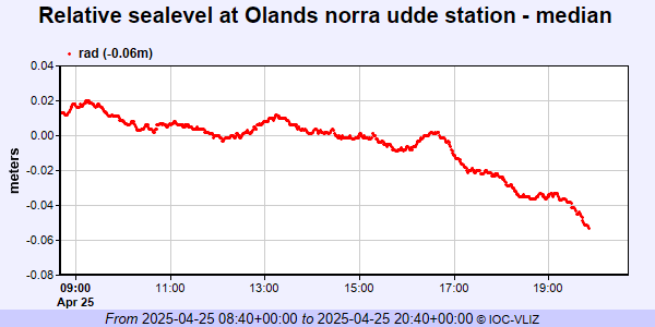 PSMSL Annual Mean Sea Level for '69' 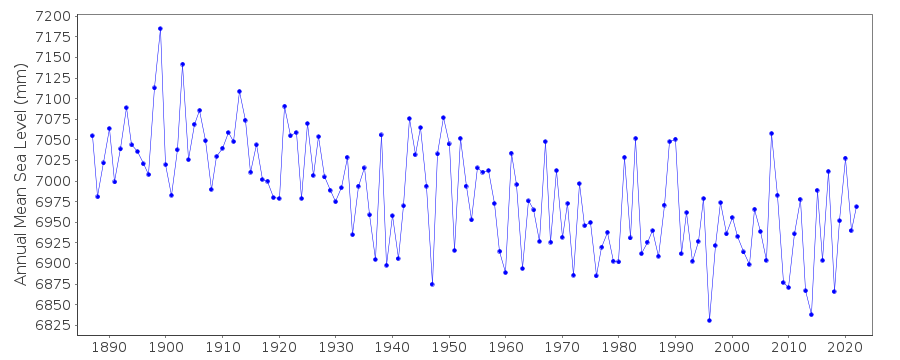 PSMSL Monthly Mean Sea Level for '69' 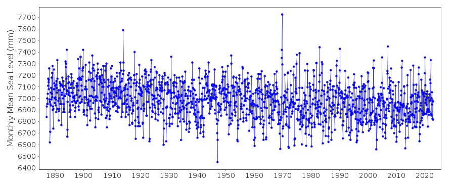
|
|
|