 |
SEALEVEL STATION CATALOG (SSC) |
|
|
|
|
|
| Station catalog metadata [edit] | [station overview] |
|---|
| SSC ID | SSC-nuku | | Station Name | Nuku Hiva | | Country | France | | Latitude | -8.914847 | | Longitude | -140.084683 | | DateLastModified | 2025-05-08 22:03:39 |
| Linked codes |
|---|
| Codes | Location | Latitude | Longitude | Sensors | IOC: nuku | Nuku Hiva (Marquesas, French Polynesia) | -8.914847 | -140.084683 | prs, rad, ra2, bat, sw1, sw2, prs |
GLOSS: 142 | Nuku Hiva, Marquesas Is. | -8.93333 | -140.08333 | Float |
UHSLC: 31 | Nuku Hiva | -8.93 | -140.082 | N/A |
PTWC: nukb | | | | |
PTWC: nuku | Nuku_Hiva_Marquesas | -8.9148 | -140.0847 | prs, ra2, rad |
PSMSL: 1555 | NUKU HIVA | -8.933333 | -140.083333 | N/A |
PSMSL: 2241 | NUKU HIVA II | -8.914927 | -140.096032 | N/A |
SONEL_GPS: 2267 | NUKU HIVA | -8.91492700 | -140.09603200 | N/A |
SONEL_TG: 2257 | NUKU HIVA | -8.91492700 | -140.09603200 | N/A |
| Distributed metadata source: IOC Sea Level Station Monitoring Facility nuku |
|---|
| GTS station code | 301434061604070 |
| GTS message type | SZXX01 |
| Status | Operational |
| Local Contact | Commissariat à l'Energie Atomique ( France ) |
| Other Contact | University of Hawaii Sea Level Center ( USA ) |
| Connection | GTS message |
| Country | France |
| Sensor 1 | |
| Type of sensor | prs |
| Sampling rate (min) | 1 |
| Sensor 2 | |
| Type of sensor | rad |
| Sampling rate (min) | 1 |
| Sensor 3 | |
| Type of sensor | ra2 |
| Sampling rate (min) | 1 |
| Sensor 4 | |
| Type of sensor | bat |
| Sampling rate (min) | 5 |
| Sensor 5 | |
| Type of sensor | prs |
| Sampling rate (min) | 1 |
| Sensor 6 | |
| Type of sensor | sw1 |
| Sampling rate (min) | 60 |
| Sensor 7 | |
| Type of sensor | sw2 |
| Sampling rate (min) | 60 |
| Distributed metadata source: GLOSS Station Handbook |
|---|
| Time Zone | 135W, GMT - 9hrs | | Ocean | Pacific | | Operational | Yes | | Data acquisition rate | 15 minute interval | | Tide gauge benchmarks | BM1: 1 inch stainless disc without stamp set in dark grey epoxy on the concrete light base at corner of the pier behind the capitanerie offices. | | Auxiliary benchmarks | BM3A: In front of cement beam which separates the 2 centre stalls of the copra shed.
BM4: stainless steel disc set in white epoxy in centre of concrete structure which supports the new tide station.
BMSWE: top of 6 inch round black ABS housing bolted onto the west tide well pipe at about the 5 foot level (ref. level switch).
| | Other relevant information | Backup gauge: Handar encoder (Apr 1986 - ).
Daily values calculated using 119-point convolution filter (Bloomfield, 1976) centred on noon applied to the hourly data with respective periods of the 95, 50 and 5% amplitude points at 124.0, 60.2 and 40.2 hours.
| | Other relevant codes | UHSLC 031 |
| Distributed metadata source: PTWC COMP META file |
| DCP ID | |
| WMO | |
| Samp Rate | |
| Num# Samp | |
| Unit | |
| Scale | |
| Xmt Int. | |
| Fst Min. | |
| HAR | |
| Owner | |
| Distributed metadata source: UHSLC |
| UHSLC id | 031 |
| SSC id | nuku |
| GLOSS id | 142 |
| UHSLC geojson | https://uhslc.soest.hawaii.edu/data/meta.geojson |
| Research quality data version a | 1982-04-01 - 2018-12-31 |
| RQ basin | pacific |
| Fast delivery | 1982-04-01 - 2026-04-30 |
| Distributed metadata source: PSMSL |
| Name | NUKU HIVA |
| GLOSS id | 142 |
| UHSLC ID | 31 |
| Is RLR | Y |
| Has RLR Diagram | Y link |
| QC Flag | N |
| Old ID | 805/011 |
| Last Updated | 2025-06-19 |
| Supplier | UNIVERSITY OF HAWAII SEA LEVEL CENTER |
| Address | University of Hawaii Sea Level Center, Department of Oceanography Division of Natural Sciences, 1000 Pope Road, Honolulu, Hawaii 96822, UNITED STATES |
| Metric Start | 1982 |
| Metric End | 2018 |
| Metric Completeness | 70.5 |
| RLR Start | 1982 |
| RLR End | 2018 |
| RLR Completeness | 70.5 |
| Download metric sea level data. | Use only with extreme caution. |
| Name | NUKU HIVA II |
| UHSLC ID | 31 |
| Is RLR | N |
| Has RLR Diagram | N link |
| QC Flag | N |
| Old ID | 805/010 |
| Last Updated | 2022-10-19 |
| Supplier | SERVICE HYD. ET OCEAN. DE LA MARINE |
| Address | SHOM, 13 rue de Chatelier, 29200 BREST , FRANCE |
| Metric Start | 1982 |
| Metric End | 2018 |
| Metric Completeness | 70.3 |
| Download metric sea level data. | Use only with extreme caution. |
IOC Sea Level Station Monitoring Facility - realtime graph for 'nuku'  PSMSL Annual Mean Sea Level for '1555' 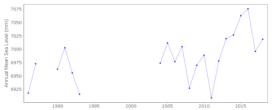 PSMSL Annual Mean Sea Level for '2241'  PSMSL Monthly Mean Sea Level for '2241' 
|
|
|