 |
SEALEVEL STATION CATALOG (SSC) |
|
|
|
|
|
| Station catalog metadata [edit] | [station overview] |
|---|
| SSC ID | SSC-nome | | Station Name | Nome | | Country | United States | | Latitude | 64.5 | | Longitude | -165.43 | | DateLastModified | 2015-10-22 19:02:29 |
| Distributed metadata source: IOC Sea Level Station Monitoring Facility nome |
|---|
| Status | Operational |
| Local Contact | National Ocean Service-NOAA ( USA ) |
| Connection | WEB service |
| Country | USA |
| Sensor 1 | |
| Type of sensor | bwl |
| Sampling rate (min) | 6 |
| Distributed metadata source: IOC Sea Level Station Monitoring Facility nome2 |
|---|
| GTS station code | 336AA720 |
| GTS message type | SXXX03 |
| Status | Down |
| Local Contact | National Ocean Service-NOAA ( USA ) |
| Connection | GTS message |
| Country | USA |
| Sensor 1 | |
| Type of sensor | pwl |
| Sampling rate (min) | 1 |
| Distributed metadata source: GLOSS Station Handbook |
|---|
| Time Zone | 135W, GMT - 10hrs | | Ocean | Pacific | | Operational | Yes | | Additional parameters | Barometric pressure, air/sea temp.,wind speed and direction | | Auxiliary benchmarks | Benchmarks include: BM M, BM G, BM H, BM F, BM E, BM D, BM C, BM B - 1993 site visit states 'levels agree with history'. | | Other relevant information | Installation of gauge took place in August 1992 by NOAA, this was a pneumatic bubbler and a Paroscientific pressure system. |
| Distributed metadata source: PTWC COMP META file |
| DCP ID | 33A58DE8 |
| WMO | SXXX03 |
| Samp Rate | 6 |
| Num# Samp | 1 |
| Unit | M |
| Scale | 1.0000 |
| Xmt Int. | 006 |
| Fst Min. | 0001 |
| HAR | 1 |
| Owner | NOS |
| Distributed metadata source: UHSLC |
| UHSLC id | 595 |
| SSC id | nome |
| GLOSS id | 74 |
| UHSLC geojson | https://uhslc.soest.hawaii.edu/data/meta.geojson |
| Research quality data version a | 1992-10-01 - 2021-12-31 |
| RQ basin | pacific |
| Fast delivery | 1992-10-01 - 2026-04-30 |
| Distributed metadata source: PSMSL |
| Name | NOME, ALASKA |
| GLOSS id | 74 |
| UHSLC ID | 595 |
| SONEL id | 2708 |
| Is RLR | Y |
| Has RLR Diagram | Y link |
| QC Flag | N |
| Old ID | 821/003 |
| Last Updated | 2026-01-28 |
| Supplier | N.O.A.A. / N.O.S. |
| Address | N.O.A.A. / N.O.S., N/oes33, Ssmc4, Room 6531, 1305 East-West Highway, Silver Spring, , MD 20910, UNITED STATES |
| Metric Start | 1992 |
| Metric End | 2025 |
| Metric Completeness | 84.1 |
| RLR Start | 1992 |
| RLR End | 2025 |
| RLR Completeness | 84.1 |
| Download metric sea level data. | Use only with extreme caution. |
IOC Sea Level Station Monitoring Facility - realtime graph for 'nome' 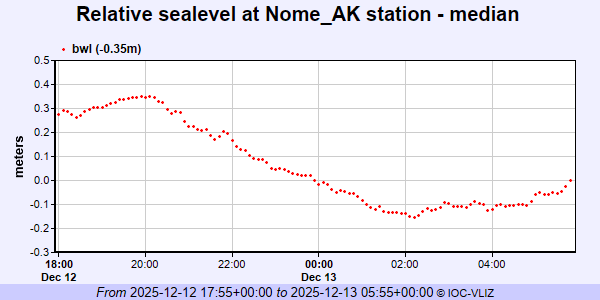 IOC Sea Level Station Monitoring Facility - realtime graph for 'nome2'  PSMSL Annual Mean Sea Level for '1800' 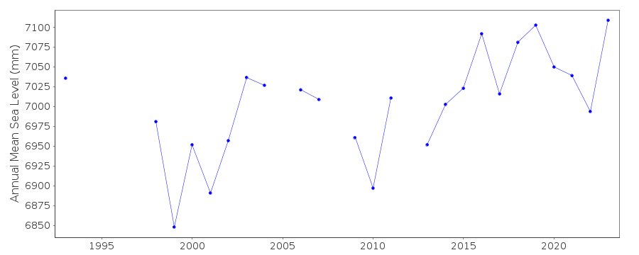 PSMSL Monthly Mean Sea Level for '1800' 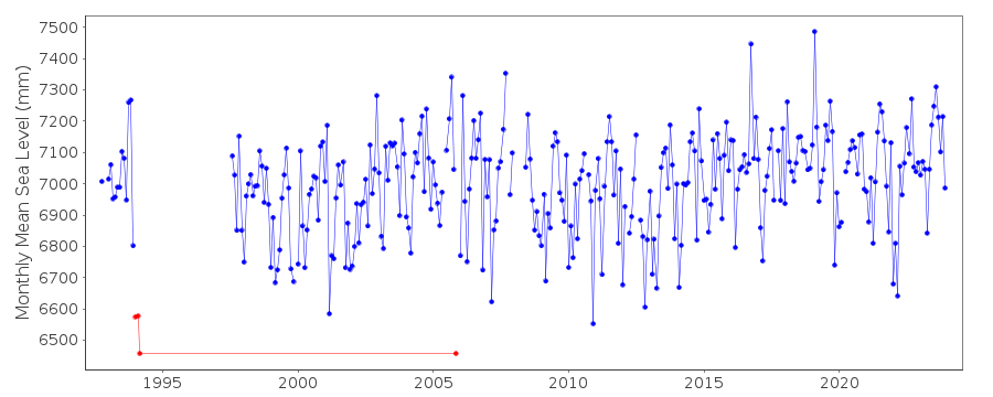
|
|
|