 |
SEALEVEL STATION CATALOG (SSC) |
|
|
|
|
|
| Station catalog metadata [edit] | [station overview] |
|---|
| SSC ID | SSC-nkfa | | Station Name | Nuku'Alofa | | Country | Tonga | | Latitude | -21.1303 | | Longitude | -175.1967 | | DateLastModified | 2022-09-13 06:40:19 |
| Linked codes |
|---|
| Codes | Location | Latitude | Longitude | Sensors | IOC: nkfa | Nuku'Alofa Harbour Wharf | -21.1303 | -175.1967 | aqu |
IOC: nkfa2 | Nuku'Alofa Harbour wharf | -21.1303 | -175.1967 | rad |
GLOSS: 125 | Tongatapu | -21.16666 | -175.25 | |
UHSLC: 38 | Nuku'alofa | -21.133 | -175.167 | N/A |
PTWC: nkf2 | Nukualofa_TO | -21.1303 | -175.1967 | prs |
PTWC: nkfa | Nukualofa_TO | -21.1380 | -175.1815 | prs |
PSMSL: 1770 | NUKU'ALOFA | -21.133333 | -175.2 | N/A |
PSMSL: 1842 | NUKU'ALOFA B | -21.136806 | -175.180694 | N/A |
SONEL_GPS: 894 | TONGA | -21.14471300 | -175.17922400 | N/A |
SONEL_TG: 2170 | TONGA | -21.13026276 | -175.19677053 | N/A |
| Distributed metadata source: IOC Sea Level Station Monitoring Facility nkfa |
|---|
| GTS station code | 66600 |
| GTS message type | SZPS01 |
| Status | Operational |
| Other Contact | National Tidal Centre/Australian Bureau of Meteorology ( Australia ) |
| Connection | GTS message |
| Country | Tonga Island |
| Sensor 1 | |
| Type of sensor | aqu |
| Sampling rate (min) | 1 |
| Distributed metadata source: IOC Sea Level Station Monitoring Facility nkfa2 |
|---|
| GTS station code | 66602 |
| GTS message type | SZPS01 |
| Status | In test |
| Other Contact | National Tidal Centre/Australian Bureau of Meteorology ( Australia ) |
| Connection | GTS message |
| Country | Tonga Island |
| Sensor 1 | |
| Type of sensor | rad |
| Sampling rate (min) | 1 |
| Distributed metadata source: GLOSS Station Handbook |
|---|
| Time Zone | 180E, GMT + 12hrs | | Ocean | Pacific | | Operational | No |
| Distributed metadata source: PTWC COMP META file |
| DCP ID | 66602 |
| WMO | SZPS01 |
| Samp Rate | 1 |
| Num# Samp | 6 |
| Unit | M |
| Scale | 1.0000 |
| Xmt Int. | 003 |
| Fst Min. | 0000 |
| HAR | 1 |
| Owner | ABM |
| Distributed metadata source: UHSLC |
| UHSLC id | 038 |
| SSC id | nkfa |
| GLOSS id | 125 |
| UHSLC geojson | https://uhslc.soest.hawaii.edu/data/meta.geojson |
| Research quality data version a | 1990-06-21 - 2021-12-31 |
| RQ basin | pacific |
| Fast delivery | 1990-06-21 - 2026-04-30 |
| Distributed metadata source: PSMSL |
| Name | NUKU'ALOFA |
| GLOSS id | 125 |
| UHSLC ID | 38 |
| Is RLR | N |
| Has RLR Diagram | N link |
| QC Flag | N |
| Old ID | 744/001 |
| Last Updated | 1996-10-30 |
| Supplier | MINISTRY OF LANDS, SURVEY AND NATURAL RES. |
| Address | Ministry of Lands, Survey and Natural Resources, P.O. Box 5, Nuku'alofa, TONGA |
| Metric Start | 1990 |
| Metric End | 1994 |
| Metric Completeness | 86.7 |
| Download metric sea level data. | Use only with extreme caution. |
| Name | NUKU'ALOFA B |
| GLOSS id | 125 |
| UHSLC ID | 38 |
| SONEL id | 894 |
| Is RLR | Y |
| Has RLR Diagram | Y link |
| QC Flag | N |
| Old ID | 744/002 |
| Last Updated | 2026-06-01 |
| Supplier | NATIONAL TIDAL CENTRE |
| Address | National Tidal Centre, Bureau of Meteorology, PO Box 421, Kent Town 5071, South Australia, AUSTRALIA |
| Metric Start | 1993 |
| Metric End | 2026 |
| Metric Completeness | 96.8 |
| RLR Start | 1993 |
| RLR End | 2026 |
| RLR Completeness | 96.8 |
| Download metric sea level data. | Use only with extreme caution. |
IOC Sea Level Station Monitoring Facility - realtime graph for 'nkfa' 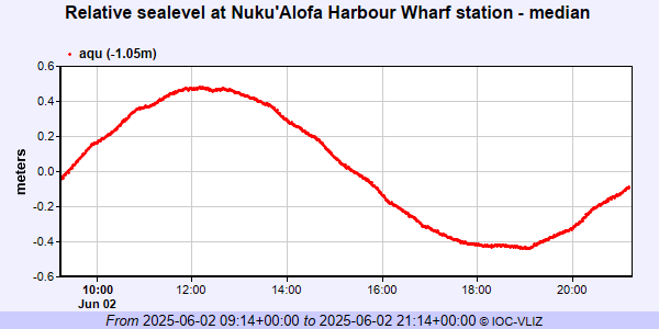 IOC Sea Level Station Monitoring Facility - realtime graph for 'nkfa2'  PSMSL Annual Mean Sea Level for '1770'  PSMSL Annual Mean Sea Level for '1842' 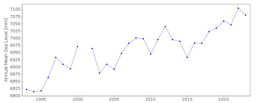 PSMSL Monthly Mean Sea Level for '1842' 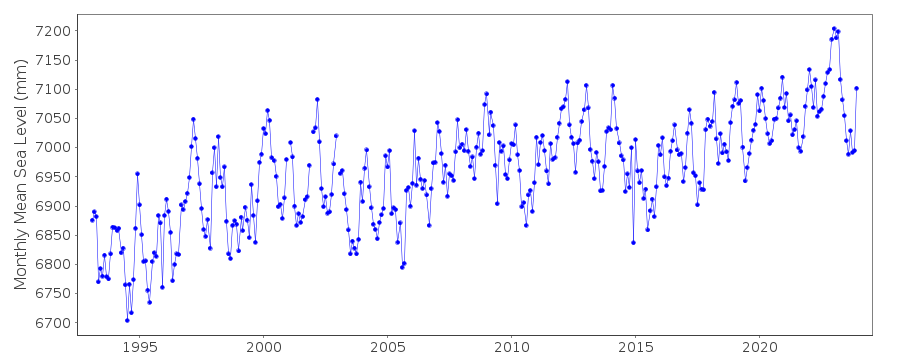
|
|
|