| Station catalog metadata [edit] | [station overview] |
|---|
| SSC ID | SSC-mumbj |
| Station Name | Mumbai / Bombay (apollo Bandar) |
| Country | India |
| Latitude | 18.916667 |
| Longitude | 72.833333 |
| DateLastModified | 2015-10-22 19:02:29 |
| Linked codes |
|---|
| Codes | Location | Latitude | Longitude | Sensors |
PSMSL: 212 | BOMBAY (PRINCES DOCK) | 18.95 | 72.833333 | N/A |
PSMSL: 43 | MUMBAI / BOMBAY (APOLLO BANDAR) | 18.916667 | 72.833333 | N/A |
| Distributed metadata source: PSMSL |
| Name | BOMBAY (PRINCES DOCK) |
| Is RLR | Y |
| Has RLR Diagram | Y link |
| QC Flag | N |
| Old ID | 500/051 |
| Last Updated | null |
| Supplier | SURVEY OF INDIA |
| Address | Survey of India, Geodetic and Research Branch, 17 E.C. Road, Dehra Dun , PIN 248 001, INDIA |
| Metric Start | 1916 |
| Metric End | 1920 |
| Metric Completeness | 100.0 |
| RLR Start | 1916 |
| RLR End | 1920 |
| RLR Completeness | 100.0 |
| Download metric sea level data. | Use only with extreme caution. |
| Name | MUMBAI / BOMBAY (APOLLO BANDAR) |
| Is RLR | Y |
| Has RLR Diagram | Y link |
| QC Flag | N |
| Old ID | 500/041 |
| Last Updated | 2026-02-02 |
| Supplier | SURVEY OF INDIA |
| Address | Survey of India, Geodetic and Research Branch, 17 E.C. Road, Dehra Dun , PIN 248 001, INDIA |
| Metric Start | 1878 |
| Metric End | 2024 |
| Metric Completeness | 87.6 |
| RLR Start | 1878 |
| RLR End | 2024 |
| RLR Completeness | 87.6 |
| Download metric sea level data. | Use only with extreme caution. |
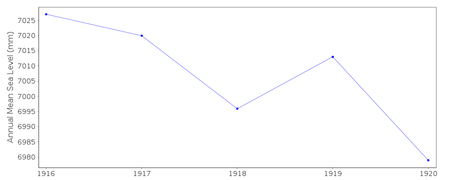
PSMSL Annual Mean Sea Level for '212'
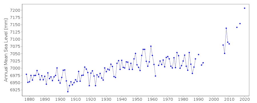
PSMSL Annual Mean Sea Level for '43'
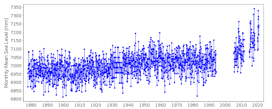
PSMSL Monthly Mean Sea Level for '43'