 |
SEALEVEL STATION CATALOG (SSC) |
|
|
|
|
|
| Station catalog metadata [edit] | [station overview] |
|---|
| SSC ID | SSC-miri | | Station Name | Miri | | Country | Malaysia | | Latitude | 4.4 | | Longitude | 113.96666 | | DateLastModified | 2015-10-22 19:02:29 |
| Distributed metadata source: UHSLC |
| UHSLC id | 388 |
| SSC id | miri |
| UHSLC geojson | https://uhslc.soest.hawaii.edu/data/meta.geojson |
| Research quality data version a | 1992-12-22 - 2015-12-18 |
| RQ basin | pacific |
| Distributed metadata source: PSMSL |
| Name | MIRI |
| UHSLC ID | 388 |
| Is RLR | Y |
| Has RLR Diagram | Y link |
| QC Flag | Y |
| Old ID | 663/001 |
| Last Updated | 2017-05-04 |
| Supplier | DEPARTMENT OF SURVEY AND MAPPING |
| Address | Department of Survey and Mapping, Wisma JUPEM, Jalan Semarak, 50578 Kuala Lumpur, MALAYSIA |
| Metric Start | 1992 |
| Metric End | 2015 |
| Metric Completeness | 56.3 |
| RLR Start | 1992 |
| RLR End | 2015 |
| RLR Completeness | 56.3 |
| Download metric sea level data. | Use only with extreme caution. |
PSMSL Annual Mean Sea Level for '1819' 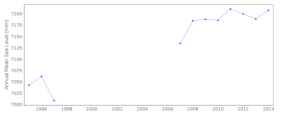 PSMSL Monthly Mean Sea Level for '1819' 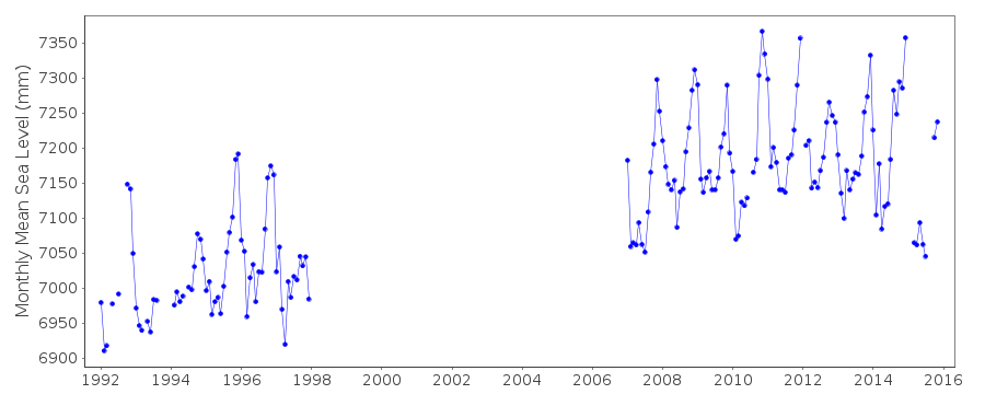
|
|
|