 |
SEALEVEL STATION CATALOG (SSC) |
|
|
|
|
|
| Station catalog metadata [edit] | [station overview] |
|---|
| SSC ID | SSC-mhav | | Station Name | Milford Haven | | Country | United Kingdom | | Latitude | 51.71 | | Longitude | -5.05 | | DateLastModified | 2015-10-22 19:02:29 |
| Linked codes |
|---|
| Codes | Location | Latitude | Longitude | Sensors | IOC: mhav | Milford Haven | 51.71 | -5.05 | bub |
PSMSL: 1700 | MILFORD HAVEN (HAKIN) | 51.707389 | -5.051528 | N/A |
PSMSL: 66 | MILFORD HAVEN (NEWTON NOYES) | 51.7 | -5.016667 | N/A |
| Distributed metadata source: IOC Sea Level Station Monitoring Facility mhav |
|---|
| Status | Operational |
| Local Contact | National Oceanography Centre ( UK ) |
| Connection | FTP box |
| Country | UK |
| Sensor 1 | |
| Type of sensor | bub |
| Sampling rate (min) | 15 |
| Distributed metadata source: PSMSL |
| Name | MILFORD HAVEN (HAKIN) |
| SONEL id | 4321 |
| Is RLR | Y |
| Has RLR Diagram | Y link |
| QC Flag | N |
| Old ID | 170/182 |
| Last Updated | 2025-02-19 |
| Supplier | ENVIRONMENT AGENCY |
| Address | Environment Agency, Horizon House, Deanery Road, BS1 5AH, Bristol, UNITED KINGDOM |
| Metric Start | 1987 |
| Metric End | 2024 |
| Metric Completeness | 78.9 |
| RLR Start | 1987 |
| RLR End | 2024 |
| RLR Completeness | 78.9 |
| Download metric sea level data. | Use only with extreme caution. |
| Name | MILFORD HAVEN (NEWTON NOYES) |
| Is RLR | Y |
| Has RLR Diagram | Y link |
| QC Flag | N |
| Old ID | 170/181 |
| Last Updated | 1987-02-20 |
| Supplier | UNITED KINGDOM HYDROGRAPHIC OFFICE |
| Address | United Kingdom Hydrographic Office, Admiralty Way, Taunton, Somerset , TA1 2DN, UNITED KINGDOM |
| Metric Start | 1886 |
| Metric End | 1983 |
| Metric Completeness | 33.2 |
| RLR Start | 1963 |
| RLR End | 1983 |
| RLR Completeness | 74.2 |
| Download metric sea level data. | Use only with extreme caution. |
IOC Sea Level Station Monitoring Facility - realtime graph for 'mhav' 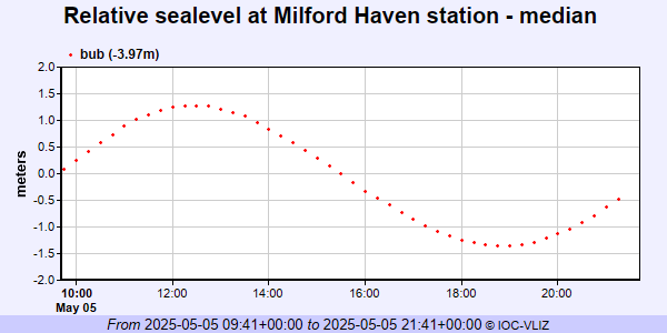 PSMSL Annual Mean Sea Level for '1700' 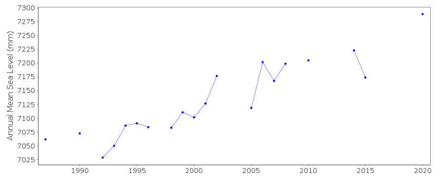 PSMSL Annual Mean Sea Level for '66' 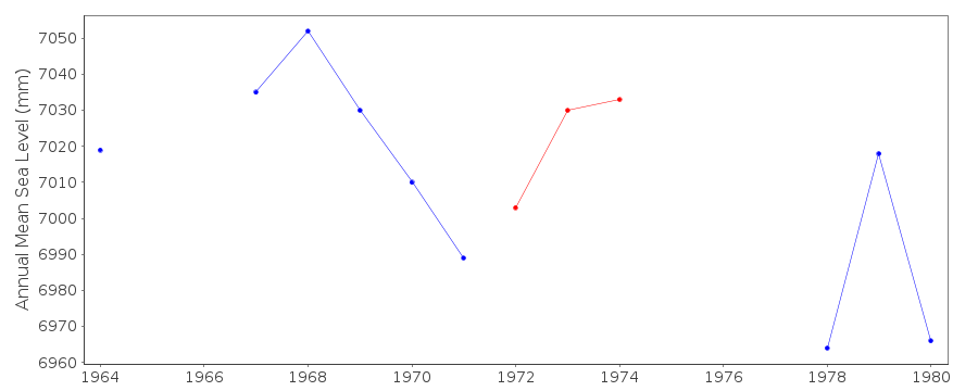 PSMSL Monthly Mean Sea Level for '66' 
|
|
|