 |
SEALEVEL STATION CATALOG (SSC) |
|
|
|
|
|
| Station catalog metadata [edit] | [station overview] |
|---|
| SSC ID | SSC-mata | | Station Name | Matarani | | Country | Peru | | Latitude | -17 | | Longitude | -72.11666 | | DateLastModified | 2015-10-22 19:02:29 |
| Linked codes |
|---|
| Codes | Location | Latitude | Longitude | Sensors | IOC: mata | Matarani,Arequipa_PE | -17.0009 | -72.1088 | prs, rad, ra2, bat, sw1, sw2, ras |
IOC: mata2 | Matarani,Arequipa PE | -17.001 | -72.1086 | rad, prs |
UHSLC: 94 | Matarani | -17.002 | -72.108 | N/A |
PTWC: mata | Matarani_PE | -17.0009 | -72.1088 | prs, rad, enc |
PSMSL: 2188 | MATARANI B | -17.001667 | -72.108333 | N/A |
PSMSL: 458 | MATARANI | -17.0 | -72.116667 | N/A |
| Distributed metadata source: IOC Sea Level Station Monitoring Facility mata |
|---|
| GTS station code | 300434064780550 |
| GTS message type | SZXX01 |
| Status | Operational |
| Local Contact | Dirección de Hidrografía y Navegación (Perú) |
| Other Contact | University of Hawaii Sea Level Center ( USA ) |
| Connection | GTS message |
| Country | Perú |
| Sensor 1 | |
| Type of sensor | prs |
| Sampling rate (min) | 1 |
| Sensor 2 | |
| Type of sensor | rad |
| Sampling rate (min) | 1 |
| Sensor 3 | |
| Type of sensor | ra2 |
| Sampling rate (min) | 1 |
| Sensor 4 | |
| Type of sensor | bat |
| Sampling rate (min) | 5 |
| Sensor 5 | |
| Type of sensor | sw1 |
| Sampling rate (min) | 60 |
| Sensor 6 | |
| Type of sensor | sw2 |
| Sampling rate (min) | 60 |
| Sensor 7 | |
| Type of sensor | ras |
| Sampling rate (min) | 1 |
| Distributed metadata source: IOC Sea Level Station Monitoring Facility mata2 |
|---|
| GTS station code | D3D04F9C |
| GTS message type | SEPO40 |
| Status | Operational |
| Local Contact | Dirección de Hidrografía y Navegación (Perú) |
| Connection | GTS message |
| Country | Perú |
| Sensor 1 | |
| Type of sensor | rad |
| Sampling rate (min) | 1 |
| Sensor 2 | |
| Type of sensor | prs |
| Sampling rate (min) | 1 |
| Distributed metadata source: PTWC COMP META file |
| DCP ID | 354176C2 |
| WMO | SEPO40 |
| Samp Rate | 5 |
| Num# Samp | 2 |
| Unit | M |
| Scale | 1.0000 |
| Xmt Int. | 005 |
| Fst Min. | 0000 |
| HAR | 1 |
| Owner | DHN |
| Distributed metadata source: UHSLC |
| UHSLC id | 094 |
| SSC id | mata |
| UHSLC geojson | https://uhslc.soest.hawaii.edu/data/meta.geojson |
| Research quality data version a | 1954-03-23 - 1964-12-31 |
| Research quality data version b | 1992-01-03 - 2011-10-14 |
| Research quality data version c | 2011-10-16 - 2019-12-31 |
| RQ basin | pacific |
| Fast delivery | 2011-10-16 - 2026-04-30 |
| Distributed metadata source: PSMSL |
| Name | MATARANI B |
| UHSLC ID | 94 |
| Is RLR | Y |
| Has RLR Diagram | Y link |
| QC Flag | N |
| Old ID | 848/055 |
| Last Updated | 2020-01-29 |
| Supplier | UNIVERSITY OF HAWAII SEA LEVEL CENTER |
| Address | University of Hawaii Sea Level Center, Department of Oceanography Division of Natural Sciences, 1000 Pope Road, Honolulu, Hawaii 96822, UNITED STATES |
| Metric Start | 1992 |
| Metric End | 2017 |
| Metric Completeness | 92.9 |
| RLR Start | 2011 |
| RLR End | 2017 |
| RLR Completeness | 95.2 |
| Download metric sea level data. | Use only with extreme caution. |
| Name | MATARANI |
| UHSLC ID | 94 |
| Is RLR | Y |
| Has RLR Diagram | Y link |
| QC Flag | N |
| Old ID | 848/051 |
| Last Updated | 1990-03-01 |
| Supplier | D.H.N.M., PERU |
| Address | Direccion de Hidrografia y Navegacion de la Marina, Camarra 500 Chucuito, Casilla Postal 80, Callao, PERU |
| Metric Start | 1941 |
| Metric End | 1988 |
| Metric Completeness | 90.1 |
| RLR Start | 1941 |
| RLR End | 1969 |
| RLR Completeness | 93.7 |
| Download metric sea level data. | Use only with extreme caution. |
IOC Sea Level Station Monitoring Facility - realtime graph for 'mata' 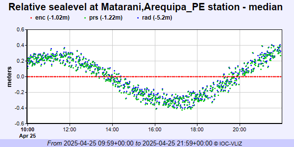 IOC Sea Level Station Monitoring Facility - realtime graph for 'mata2' 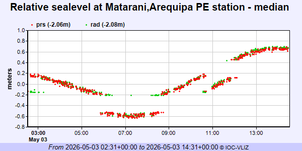 PSMSL Annual Mean Sea Level for '2188' 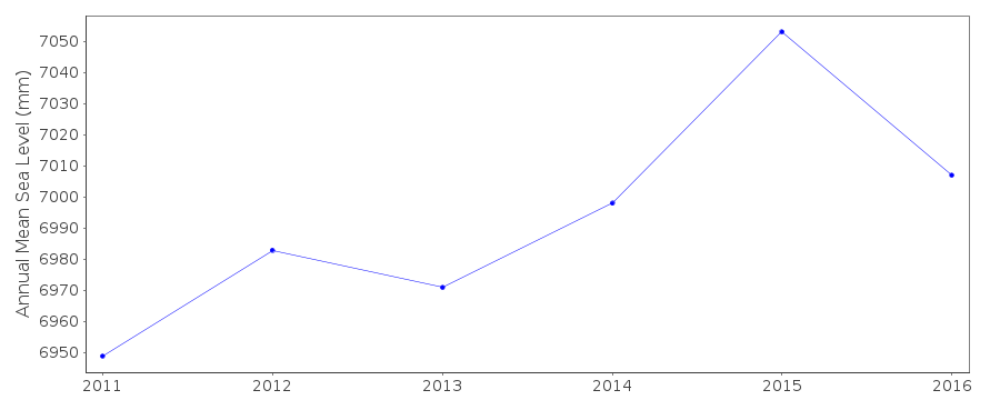 PSMSL Annual Mean Sea Level for '458' 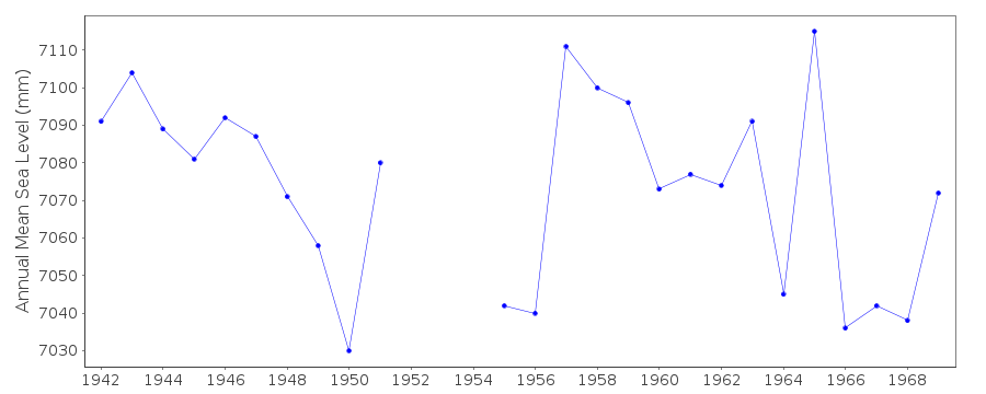 PSMSL Monthly Mean Sea Level for '458' 
|
|
|