 |
SEALEVEL STATION CATALOG (SSC) |
|
|
|
|
|
| Station catalog metadata [edit] | [station overview] |
|---|
| SSC ID | SSC-marsh | | Station Name | Majuro | | Country | Marshall Islands | | Latitude | 7.1061 | | Longitude | 171.3725 | | DateLastModified | 2015-10-22 19:02:29 |
| Distributed metadata source: IOC Sea Level Station Monitoring Facility marsh |
|---|
| GTS station code | 67680 |
| GTS message type | SZPA01 |
| Status | Operational |
| Local Contact | National Tidal Centre/Australian Bureau of Meteorology ( Australia ) |
| Connection | GTS message |
| Country | Marshall Islands |
| Sensor 1 | |
| Type of sensor | rad |
| Sampling rate (min) | 1 |
| Distributed metadata source: GLOSS Station Handbook |
|---|
| Time Zone | 180E, GMT + 12hrs | | Ocean | Pacific | | Operational | Yes | | Tide gauge benchmarks | BM1 SS bolt, no stamp, embedded in the concrete roadway to the dock next to the curb about 2 ft south of tide station foundation | | Auxiliary benchmarks | BM2:SS bolt embedded in the corner of the concrete slab by electrical vault which is on the NW side of the freezer of fishery pier.
BM4:SS bolt, no stamp, embedded in concrete curb of the copra dock road way at the top of the incline just past the power station pump house.
BM3A: replaces BM3, on rise near the guard rail at SW corner of freezer plant, 5ft from BM3.
| | Other relevant information | Backup gauge on site: Handar encoder (August 1983-).
Daily values calculated using 119-point convolution filter (Bloomfield, 1976) centred on noon applied to the hourly data with respective periods of the 95, 50 and 5% amplitude points at 124.0, 60.2 and 40.2 hours.
| | Other relevant codes | UHSLC 005 |
| Distributed metadata source: PTWC COMP META file |
| DCP ID | 67680 |
| WMO | SZPA01 |
| Samp Rate | 1 |
| Num# Samp | 6 |
| Unit | M |
| Scale | 1.0000 |
| Xmt Int. | 003 |
| Fst Min. | 0000 |
| HAR | 1 |
| Owner | ABM |
| Distributed metadata source: UHSLC |
| UHSLC id | 005 |
| SSC id | marsh |
| GLOSS id | 112 |
| UHSLC geojson | https://uhslc.soest.hawaii.edu/data/meta.geojson |
| Research quality data version a | 1968-10-07 - 1999-12-31 |
| Research quality data version b | 1993-05-14 - 2021-12-31 |
| RQ basin | pacific |
| Fast delivery | 1993-05-14 - 2026-04-30 |
| Distributed metadata source: PSMSL |
| Name | MAJURO-B |
| GLOSS id | 112 |
| UHSLC ID | 5 |
| SONEL id | 2055 |
| Is RLR | Y |
| Has RLR Diagram | Y link |
| QC Flag | N |
| Old ID | 720/016 |
| Last Updated | 2001-03-21 |
| Supplier | UNIVERSITY OF HAWAII SEA LEVEL CENTER |
| Address | University of Hawaii Sea Level Center, Department of Oceanography Division of Natural Sciences, 1000 Pope Road, Honolulu, Hawaii 96822, UNITED STATES |
| Metric Start | 1968 |
| Metric End | 1999 |
| Metric Completeness | 89.3 |
| RLR Start | 1968 |
| RLR End | 1999 |
| RLR Completeness | 89.3 |
| Download metric sea level data. | Use only with extreme caution. |
| Name | MAJURO A |
| GLOSS id | 112 |
| Is RLR | N |
| Has RLR Diagram | N link |
| QC Flag | N |
| Old ID | 720/015 |
| Last Updated | 1996-10-30 |
| Supplier | SCRIPPS INSTITUTION OF OCEANOGRAPHY |
| Address | Scripps Institution of Oceanography, University of California, La Jolla, California 92093, UNITED STATES |
| Metric Start | 1968 |
| Metric End | 1972 |
| Metric Completeness | 85.0 |
| Download metric sea level data. | Use only with extreme caution. |
| Name | MAJURO-C |
| GLOSS id | 112 |
| UHSLC ID | 5 |
| SONEL id | 2055 |
| Is RLR | Y |
| Has RLR Diagram | Y link |
| QC Flag | N |
| Old ID | 720/017 |
| Last Updated | 2026-06-01 |
| Supplier | NATIONAL TIDAL CENTRE |
| Address | National Tidal Centre, Bureau of Meteorology, PO Box 421, Kent Town 5071, South Australia, AUSTRALIA |
| Metric Start | 1993 |
| Metric End | 2026 |
| Metric Completeness | 93.4 |
| RLR Start | 1993 |
| RLR End | 2026 |
| RLR Completeness | 93.4 |
| Download metric sea level data. | Use only with extreme caution. |
IOC Sea Level Station Monitoring Facility - realtime graph for 'marsh' 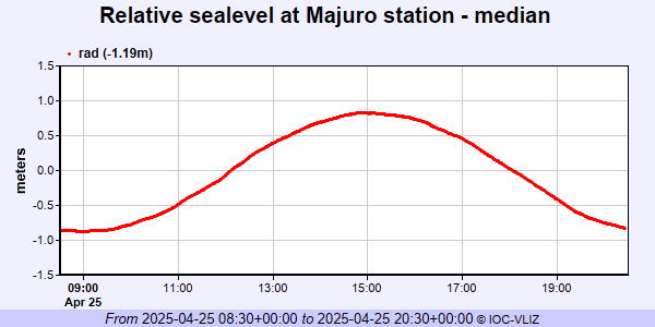 PSMSL Annual Mean Sea Level for '1217'  PSMSL Annual Mean Sea Level for '1228'  PSMSL Annual Mean Sea Level for '1838' 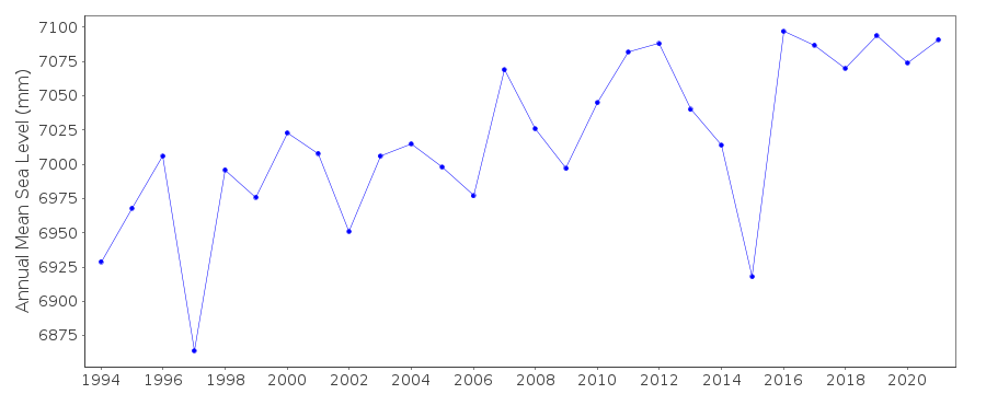 PSMSL Monthly Mean Sea Level for '1838' 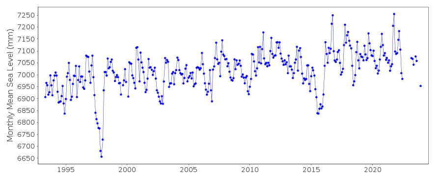
|
|
|