 |
SEALEVEL STATION CATALOG (SSC) |
|
|
|
|
|
| Station catalog metadata [edit] | [station overview] |
|---|
| SSC ID | SSC-marm | | Station Name | Marmagao | | Country | India | | Latitude | 15.41666 | | Longitude | 73.8 | | DateLastModified | 2015-10-22 19:02:29 |
| Distributed metadata source: IOC Sea Level Station Monitoring Facility marm |
|---|
| GTS station code | 43195 |
| GTS message type | SZZZ34 |
| Status | Operational |
| Local Contact | Indian National Centre for Ocean Information Services ( India ) |
| Connection | FTP box |
| Country | India |
| Sensor 1 | |
| Type of sensor | prs |
| Sampling rate (min) | 1 |
| Distributed metadata source: GLOSS Station Handbook |
|---|
| Ocean | Indian | | Operational | Yes | | Responsible country | India | | Data acquisition rate | Continuous recording | | Tide gauge benchmarks | B.M. No. 21/132 - type 'B' at Marmagao Harbour | | Benchmark relationships | 4.85m above chart datum (1969) | | Other relevant information | GPS and real time data available |
| Distributed metadata source: PTWC COMP META file |
| DCP ID | 1234ABAA |
| WMO | FTPIO1 |
| Samp Rate | 1 |
| Num# Samp | 10 |
| Unit | m |
| Scale | 1.0000 |
| Xmt Int. | 010 |
| Fst Min. | 0000 |
| HAR | 0 |
| Owner | INCOIS |
| Distributed metadata source: PSMSL |
| Name | MORMUGAO |
| GLOSS id | 281 |
| Is RLR | Y |
| Has RLR Diagram | Y link |
| QC Flag | N |
| Old ID | 500/065 |
| Last Updated | 2025-03-03 |
| Supplier | SURVEY OF INDIA |
| Address | Survey of India, Geodetic and Research Branch, 17 E.C. Road, Dehra Dun , PIN 248 001, INDIA |
| Metric Start | 1969 |
| Metric End | 2023 |
| Metric Completeness | 72.7 |
| RLR Start | 1969 |
| RLR End | 2023 |
| RLR Completeness | 72.7 |
| Download metric sea level data. | Use only with extreme caution. |
IOC Sea Level Station Monitoring Facility - realtime graph for 'marm' 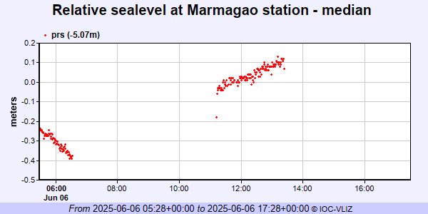 PSMSL Annual Mean Sea Level for '1249' 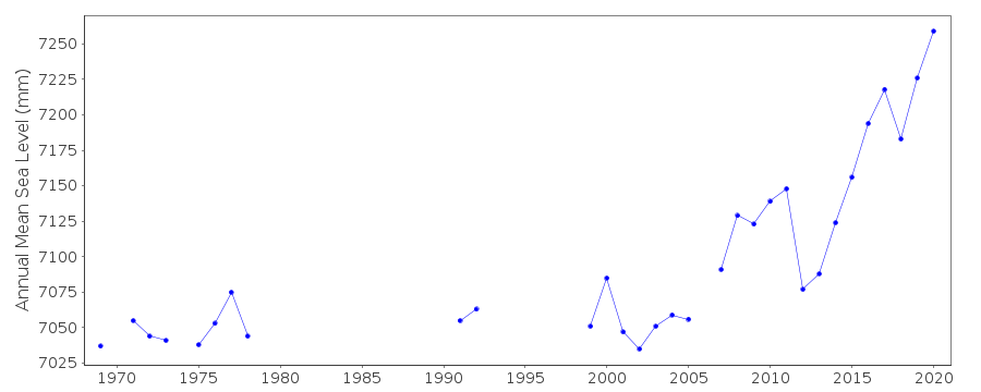 PSMSL Monthly Mean Sea Level for '1249' 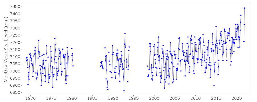
|
|
|